
George Washington Cable.
“Posson Jone.”
Notes to Next Group
- The numbers throughout the file should be checked and edited.
- The symbols and special characters were all fixed.
- If there is any formatting informalities, those should be edited as well.
- Page numbers look the same as footnote numbers. Remove the page numbers. Be careful to leave in the footnote numbers.
- Take out the square brackets around the footnotes and make the footnotes superscript. Change the footnotes at the bottom to a bulleted list. Take out the square brackets around those as well, and make those superscript as well.
| THE English and French In North America 1689-1763 |
|
NARRATIVE AND CRITICAL
HISTORY OF AMERICA
EDITED
By JUSTIN WINSOR
LIBRARIAN OF HARVARD UNIVERSITY
CORRESPONDING SECRETARY MASSACHUSETTS HISTORICAL SOCIETY
VOL. V
BOSTON AND NEW YORK
HOUGHTON, MIFFLIN AND COMPANY
The Riverside Press, Cambridge
Copyright, 1887,
By HOUGHTON, MIFFLIN & CO.
All rights reserved.
The Riverside Press, Cambridge, Mass., U. S. A.
Electrotyped and Printed by H. O. Houghton & Company.
CONTENTS AND ILLUSTRATIONS.
[The cut on the title shows the medal struck to commemorate the fall of Quebec.]
| CHAPTER I. | |
| PAGE | |
| Canada and Louisiana. Andrew McFarland Davis | 1 |
| Illustrations: La Présentation, 3; Autograph of Callières, 4; of Vaudreuil, 5; of Beauharnois, 7; of La Jonquière and of La Galissonière, 8; One of Céloron’s Plates, 9; Portrait of Lemoyne d’Iberville, with Autograph, 15; Environs du Mississipi (1700), 22; Portrait of Bienville, with Autograph, 26; Autograph of Lamothe, 29; of Lepinay, 31; Fac-simile of Bill of the Banque Royale, 34; Plans of New Orleans, 37, 38; View of New Orleans, 39; Map of the Mississippi, near New Orleans, 41; Fort Rosalie and Environs, 47; Plan of Fort Chartres, 54; Autograph of Vaudreuil, 57. | |
| Critical Essay | 63 |
| Illustrations: Autograph of La Harpe, 63; Portrait of Charlevoix, with Autograph, 64; Autograph of Le Page, 65; Map of the Mouths of the Mississippi, 66; Autograph of De Vergennes, 67; Coxe’s Map of Carolana, 70. | |
| Editorial Notes | 75 |
| Illustrations: Portrait of John Law, 75; his Autograph, 76. | |
| CARTOGRAPHY OF LOUISIANA AND THE MISSISSIPPI BASIN UNDER THE FRENCH DOMINATION. The Editor | 79 |
| Illustrations: Map of Louisiana, in Dumont, 82; Huske’s Map (1755), 84; Map of Louisiana, by Le Page du Pratz, 86. | |
NARRATIVE AND CRITICAL
HISTORY OF AMERICA.
CHAPTER I.
CANADA AND LOUISIANA.
BY ANDREW McFARLAND DAVIS,
American Antiquarian Society.
THE story of the French occupation in America is not that of a people slowly moulding itself into a nation. In France there was no state but the king; in Canada there could be none but the governor. Events cluster around the lives of individuals. According to the discretion of the leaders the prospects of the colony rise and fall. Stories of the machinations of priests at Quebec and at Montreal, of their heroic sufferings at the hands of the Hurons and the Iroquois, and of individual deeds of valor performed by soldiers, fill the pages of the record. The prosperity of the colony rested upon the fate of a single industry, — the trade in peltries. In pursuit of this, the hardy trader braved the danger from lurking savage, shot the boiling rapids of the river in his light bark canoe, ventured upon the broad bosom of the treacherous lake, and patiently endured sufferings from cold in winter and from the myriad forms of insect life which infest the forests in summer. To him the hazard of the adventure was as attractive as the promised reward. The sturdy agriculturist planted his seed each year in dread lest the fierce war-cry of the Iroquois should sound in his ear, and the sharp, sudden attack drive him from his work. He reaped his harvest with urgent haste, ever expectant of interruption from the same source, always doubtful as to the result until the crop was fairly housed. The brief season of the Canadian summer, the weary winter, the hazards of the crop, the feudal tenure of the soil, — all conspired to make the life of the farmer full of hardship and barren of promise. The sons of the early settlers drifted to the woods as independent hunters and traders. The parent State across the water, which undertook to say who might trade, and[2] where and how the traffic should be carried on, looked upon this way of living as piratical. To suppress the crime, edicts were promulgated from Versailles and threats were thundered from Quebec. Still, the temptation to engage in what Parkman calls the “hardy, adventurous, lawless, fascinating fur-trade” was much greater than to enter upon the dull monotony of ploughing, sowing, and reaping. The Iroquois, alike the enemies of farmer and of trader, bestowed their malice impartially upon the two callings, so that the risk was fairly divided. It was not surprising that the life of the fur-trader “proved more attractive, absorbed the enterprise of the colony, and drained the life-sap from other branches of commerce.” It was inevitable, with the young men wandering off to the woods, and with the farmers habitually harassed during both seed-time and harvest, that the colony should at times be unable to produce even grain enough for its own use, and that there should occasionally be actual suffering from lack of food. It often happened that the services of all the strong men were required to bear arms in the field, and that there remained upon the farms only old men, women, and children to reap the harvest. Under such circumstances want was sure to follow during the winter months. Such was the condition of affairs in 1700. The grim figure of Frontenac had passed finally from the stage of Canadian politics. On his return, in 1689, he had found the name of Frenchman a mockery and a taunt.[1] The Iroquois sounded their threats under the very walls of the French forts. When, in 1698, the old warrior died, he was again their “Onontio,” and they were his children. The account of what he had done during those years was the history of Canada for the time. His vigorous measures had restored the self-respect of his countrymen, and had inspired with wholesome fear the wily savages who threatened the natural path of his fur-trade. The tax upon the people, however, had been frightful. A French population of less than twelve thousand had been called upon to defend a frontier of hundreds of miles against the attacks of a jealous and warlike confederacy of Indians, who, in addition to their own sagacious views upon the policy of maintaining these wars, were inspired thereto by the great rival of France behind them.
To the friendship which circumstances cemented between the English and the Iroquois, the alliance between the French and the other tribes was no fair offset. From the day when Champlain joined the Algonquins and aided them to defeat their enemies near the site of Ticonderoga, the hostility of the great Confederacy had borne an important part in the history of Canada. Apart from this traditional enmity, the interests of the Confederacy rested with the English, and not with the French. If the Iroquois permitted the Indians of the Northwest to negotiate with the French, and interposed no obstacle to the transportation of peltries from the upper lakes to Montreal and Quebec, they would forfeit all the commercial benefits which belonged to their geographical position. Thus their natural tendency was to join with the English. The value of neutrality was[3] plain to their leaders; nevertheless, much of the time they were the willing agents of the English in keeping alive the chronic border war.

LA PRÉSENTATION.
[After a plan in the contemporary Mémoires sur le Canada, 1749-1760, published by the Literary and Historical Society of Quebec (réimpression), 1873, p. 13. — Ed.]
Nearly all the Indian tribes understood that the conditions of trade were better with the English than with the French; but the personal influence of the French with their allies was powerful enough partially to overcome this advantage of their rivals. This influence was exercised not only[4] through missionaries,[2] but was also felt through the national characteristics of the French themselves, which were strongly in harmony with the spirit of forest life. The Canadian bushrangers appropriated the ways and the customs of the natives. They were often adopted into the tribes, and when this was done, their advice in council was listened to with respect. They married freely into the Indian nations with whom they were thrown; and the offspring of these marriages, scattered through the forests of the Northwest, were conspicuous among hunters and traders for their skill and courage. “It has been supposed for a long while,” says one of the officers of the colony, “that to civilize the savages it was necessary to bring them in contact with the French. We have every reason to recognize the fact that we were mistaken. Those who have come in contact with us have not become French, while the French who frequent the wilds have become savages.” Prisoners held by the Indians often concealed themselves rather than return to civilized life, when their surrender was provided for by a treaty of peace.[3]

Powerful as these influences had proved with the allies of the French, no person realized more keenly than M. de Callières, the successor of Frontenac, how incompetent they were to overcome the natural drift of the Iroquois to the English. He it was who had urged at Versailles the policy of carrying the war into the province of New York as the only means of ridding Canada of the periodic invasions of the Iroquois.[4] He had joined with Frontenac in urging upon the astute monarch who had tried the experiment of using Iroquois as galley-slaves, the impolicy of abandoning the posts at Michilimakinac and at St. Joseph. His appointment was recognized as suitable, not only by the colonists, but also by Charlevoix, who tells us that “from the beginning he had acquired great influence over the savages, who recognized in him a man exact in the performance of his word, and who insisted that others should adhere to promises given to him.” He saw accomplished what Frontenac had labored for, — a peace with the Iroquois in which the allied tribes were included. The Hurons, the Ottawas, the Abenakis, and the converted Iroquois having accepted the terms of the peace, the Governor-General, the Intendant, the Governor of Montreal, and the ecclesiastical authorities signed a provisional treaty on the 8th of September, 1700. In 1703, while the Governor still commanded the confidence of his countrymen, his career was cut short by death.

The reins of government now fell into the hands of Philippe de Vaudreuil, who retained the position of governor until his death. During the entire period of his administration Canada was free from the horrors of Indian invasion. By his adroit management, with the aid of Canadians adopted by the tribes, and of missionaries, the Iroquois were held in check. The scene in which startled villagers were roused from their midnight slumber by the fierce war-whoop, the report of the musket, and the light of burning dwellings, was transferred from the Valley of the St. Lawrence to New England. Upon Vaudreuil must rest the responsibility for the attacks upon Deerfield in 1704 and Haverhill in 1708, and for the horrors of the Abenakis war. The pious Canadians, fortified by a brief preliminary invocation of Divine aid, rushed upon the little settlements and perpetrated cruelties of the same class with those which characterized the brutal attacks of the Iroquois upon the villages in Canada. The cruel policy of maintaining the alliance with the Abenakis, and at the same time securing quiet in Canada by encouraging raids upon the defenceless towns of New England, not only left a stain upon the reputation of Vaudreuil, but it also hastened the end of French power in America by convincing the growing, prosperous, and powerful colonies known as New England that the only path to permanent peace lay through the downfall of French rule in Canada.[5]
Aroused to action by Canadian raids, the New England colonies increased their contributions to the military expeditions by way of Lake Champlain and the St. Lawrence, which had become and remained, until Wolfe’s success obviated their necessity, the recognized method of attack on Canada. During Vaudreuil’s time these expeditions were singularly unfortunate. Some extraneous incident protected Quebec each year.[6] It is not strange that such disasters to the English were looked upon by the pious French as a special manifestation of the interest taken in Canada by the Deity. Thanks were given in all parts of the colony to God, who had thus directly saved the province, and special fêtes were celebrated in honor of Notre Dame des Victoires.
The total population of Canada at this time was not far from eighteen thousand. The English colonies counted over four hundred thousand inhabitants. The French Governor, in a despatch to M. de Pontchartrain, called attention, in 1714, to the great disproportion of strength between the French and English settlements, and added that there could be little doubt that on the occasion of the first rupture the English would make a powerful effort to get possession of Canada. The English colonies were in themselves strong enough easily to have overthrown the French in America. In addition, they were supported by the Home Government; while Louis XIV., defeated, humiliated, baffled at every turn, was compelled supinely[6] to witness these extraordinary efforts to wrest from him the colonies in which he had taken such personal interest. Well might the devout Canadian offer up thanks for his deliverance from the defeat which had seemed inevitable! Well might he ascribe it to an interposition of Divine Providence in his behalf! Under the circumstances we need not be surprised that a learned prelate should chronicle the fact that the Baron de Longueuil, before leaving Montreal in command of a detachment of troops, “received from M. de Belmont, grand vicaire, a flag around which that celebrated recluse, Mlle. Le Ber, had embroidered a prayer to the Holy Virgin,” nor that it should have been noticed that on the very day on which was finished “a nine days’ devotion to Notre Dame de Pitié,” the news of the wreck of Sir Hovenden Walker’s fleet reached Quebec.[7] Such coincidences appeal to the imagination. Their record, amid the dry facts of history, shows the value which was attached to what Parkman impatiently terms this “incessant supernaturalism.” To us, the skilful diplomacy of Vaudreuil, the intelligent influence of Joncaire (the adopted brother of the Senecas), the powerful aid of the missionaries, the stupid obstinacy of Sir Hovenden Walker, and certain coincidences of military movements in Europe at periods critical for Canada, explain much more satisfactorily the escape of Canada from subjection to the English during the period of the wars of the Spanish Succession.
Although Vaudreuil could influence the Iroquois to remain at peace, he could not prevent an outbreak of the Outagamis at Detroit. This, however, was easily suppressed. The nominal control of the trade of the Northwest remained with the French; but the value of this control was much reduced by the amount of actual traffic which drifted to Albany and New York, drawn thither by the superior commercial inducements offered by the English.
The treaty of Utrecht, in 1713, established the cession of Acadia to the English by its “ancient limits.” When the French saw that the English pretension to claim by these words all the territory between the St. Lawrence River and the ocean, was sure to cut them off by water from their colony at Quebec, in case of another war, they on their part confined such “ancient limits” to the peninsula now called Nova Scotia. France, to strengthen the means of maintaining her interpretation, founded the fortress and naval station of Louisbourg.
About the same time the French also determined to strengthen the fortifications of Quebec and Montreal; and in 1721 Joncaire established a post among the Senecas at Niagara.[8]
In 1725 Vaudreuil died. Ferland curtly says that the Governor’s wife was the man of the family; but so far as the record shows, the preservation[7] of Canada to France during the earlier part of his administration was largely due to his vigilance and discretion. Great judgment and skill were shown in dealing with the Indians. A letter of remonstrance from Peter Schuyler bears witness that contemporary judgment condemned his policy in raiding upon the New England colonies; but in forming our estimate of his character we must remember that the French believed that similar atrocities, committed by the Iroquois in the Valley of the St. Lawrence, were instigated by the English.

The administration[9] of M. de Beauharnois, his successor, who arrived in the colony in 1726, was not conspicuous. He appears to have been personally popular, and to have appreciated fairly the needs of Canada. The Iroquois were no longer hostile. The days of the martyrdom of the Brebeufs and the Lallemands were over.[10] In the Far West a company of traders founded a settlement at the foot of Lake Pepin, which they called Fort Beauharnois. As the trade with the Valley of the Mississippi developed, routes of travel began to be defined. Three of these were especially used, — one by way of Lake Erie, the Maumee, and the Wabash, and then down the Ohio; another by way of Lake Michigan, the Chicago River, a portage to the Illinois, and down that river; a third by way of Green Bay, Fox River, and the Wisconsin, — all three being independent of La Salle’s route from the foot of Lake Michigan to the Kankakee and Illinois rivers.[11] By special orders from France, Joncaire’s post at Niagara had been regularly fortified. The importance of this movement had been fully appreciated by the English. As an offset to that post, a trading establishment had been opened at Oswego; and now that a fort was built at Niagara, Oswego was garrisoned. The French in turn constructed a fort at Crown Point, which threatened Oswego, New York, and New England.
The prolonged peace permitted considerable progress in the development of the agricultural resources of the country. Commerce was extended as much as the absurd system of farming out the posts, and the trading privileges retained by the governors, would permit. Postal arrangements were established between Montreal and Quebec in 1721. The population at that time was estimated at twenty-five thousand. Notwithstanding the[8] evident difficulty experienced in taking care of what country the French then nominally possessed, M. Varenne de Vérendrye in 1731 fitted out an expedition to seek for the “Sea of the West,” [12] and actually penetrated to Lake Winnipeg.
The foundations of society were violently disturbed during this administration by a quarrel which began in a contest over the right to bury a dead bishop. Governor, Intendant, council, and clergy took part. “Happily,” says a writer to whom both Church and State were dear, “M. de Beauharnois did not wish to take violent measures to make the Intendant obey him, otherwise we might have seen repeated the scandalous scenes of the evil days of Frontenac.”

After the fall of Louisbourg, in 1745, Beauharnois was recalled, and Admiral de la Jonquière was commissioned as his successor; but he did not then succeed in reaching his post. It is told in a later chapter how D’Anville’s fleet, on which he was embarked, was scattered in 1746; and when he again sailed, the next year, with other ships, an English fleet captured him and bore him to London.
In consequence of this, Comte de la Galissonière was appointed Governor of Canada in 1747. His term of office was brief; but he made his mark as one of the most intelligent of those who had been called upon to administer the affairs of this government. He proceeded at once to fortify the scattered posts from Lake Superior to Lake Ontario. He forwarded to France a scheme for colonizing the Valley of the Ohio; and in order to protect the claims of France to this vast region, he sent out an expedition,[13] with instructions to bury at certain stated points leaden plates upon which were cut an assertion of these claims. These instructions were fully carried out, and depositions establishing the facts were executed and transmitted to France. He notified the Governor of Pennsylvania of the steps which had been taken, and requested him to prevent his people from trading beyond the Alleghanies,[14][9] as orders had been given to seize any English merchants found trading there. An endeavor was made to establish at Bay Verte a settlement which should offset the growing importance of Halifax, founded by the English. The minister warmly supported La Galissonière in this, and made him a liberal money allowance in aid of the plan. While busily engaged upon this scheme, he was recalled. Before leaving, he prepared for his successor a statement of the condition of the colony and its needs.[15]

FAC-SIMILE OF ONE OF CÉLORON’S PLATES, 1749.
[Reduced from the fac-simile given in the Pennsylvania Archives, second series, vi. 80. Of some of these plates which have been found, see accounts in Parkman, Montcalm and Wolfe, i. 62, and Dinwiddie Papers, i. 95, published by the Virginia Historical Society. Cf. also Appendix A to the Mémoires sur le Canada depuis 1749 jusqu’à� 1760, published by the Literary and Historical Society of Quebec, 1873 (réimpression). — Ed.]
By the terms of the peace of Aix-la-Chapelle, France in 1748 acquired possession of Louisbourg. La Jonquière, who was at the same time liberated, and who in 1749 assumed the government under his original appointment, did not agree with the Acadian policy of his predecessor. He feared the consequences of an armed collision with the English in Nova Scotia, which this course was likely to precipitate. This caution on his part brought down upon him a reprimand from Louis XV. and positive orders to[10] carry out La Galissonière’s programme. In pursuance of these instructions, the neck of the peninsula, which according to the French claim formed the boundary of Acadia, was fortified. The conservatism of the English officer prevented a conflict. In 1750, avoiding the territory in dispute, the English fortified upon ground admitted to be within their own lines, and watched events. On the approach of the English, the unfortunate inhabitants of Beaubassin abandoned their homes and sought protection under the French flag.
Notwithstanding the claims to the Valley of the Ohio put forth by the French, the English Government in 1750 granted to a company six hundred thousand acres of land in that region; and English colonial governors continued to issue permits to trade in the disputed territory. Following the instructions of the Court, as suggested by La Galissonière, English traders were arrested, and sent to France as prisoners. The English, by way of reprisal, seized French traders found in the same region.[16] The treaty of Aix-la-Chapelle had provided for a commission to adjust the boundaries between the French and the English possessions. By the terms of the treaty, affairs were to remain unchanged until the commission could determine the boundaries between the colonies. Events did not stand still during the deliberations of the commission; and the doubt whether every act along the border was a violation of the treaty hung over the heads of the colonists like the dispute as to the boundaries of Acadia, which was a constant threat of war. The situation all along the Acadian frontier and in the Valley of the Ohio was now full of peril. To add to the difficulty of the crisis in Canada, the flagrant corruption of the Intendant Bigot, with whom the Governor was in close communication, created distrust and dissatisfaction. Charges of nepotism and corruption were made against La Jonquière. The proud old man demanded his recall; but before he could appear at Court to answer the charges, chagrin and mortification caused his wounds to open, and he died on the 17th of May, 1752. Thereupon the government fell to the Baron de Longueuil till a new governor could arrive.
Bigot, whose name, according to Garneau, will hereafter be associated with all the misfortunes of France upon this continent, was Intendant at Louisbourg at the time of its fall. Dissatisfaction with him on the part of the soldiers at not receiving their pay was alleged as an explanation of[11] their mutinous behavior. He was afterward attached to the unfortunate fleet which was sent out to recapture the place. Later his baneful influence shortened the days and tarnished the reputation of La Jonquière.
In July, 1752, the Marquis Duquesne de Menneville assumed charge of the government, under instructions to pursue the policy suggested by La Galissonière. He immediately held a review of the troops and militia. At that time the number of inhabitants capable of bearing arms was about thirteen thousand. There existed a line of military posts from the St. Lawrence to the Mississippi, composed of Quebec, Montreal, Ogdensburg, Kingston, Toronto, Detroit, the Miami River, St. Joseph, Chicago, and Fort Chartres. The same year that Duquesne was installed, he took preliminary steps toward forwarding troops to occupy the Valley of the Ohio, and in 1753 these steps were followed by the actual occupation in force of that region. Another line of military posts was erected, with the intention of preventing the English from trading in that valley and of asserting the right of the French to the possession of the tributaries of the Mississippi. This line began at Niagara, and ultimately comprehended Erie, French Creek,[17] Venango, and Fort Duquesne. All these posts were armed, provisioned, and garrisoned.
All French writers agree in calling the peace of Aix-la-Chapelle a mere truce. If the sessions of the commissioners appointed to determine the boundaries upon the ante-bellum basis had resulted in aught else than bulky volumes,[18] their decision would have been practically forestalled by the French in thus taking possession of all the territory in dispute. To this, however, France was impelled by the necessities of the situation. Unless she could assume and maintain this position, the rapidly increasing population of the English colonies threatened to overflow into the Valley of the Ohio; and the danger was also imminent that the French might be dispossessed from the southern tributaries of the St. Lawrence. Once in possession, English occupation would be permanent. The aggressive spirit of La Galissonière had led him to recommend these active military operations, which, while they tended to provoke collision, could hardly fail to check the movement of colonization which threatened the region in dispute. On the Acadian peninsula the troops had come face to face without bloodshed. The firmness of the French commander in asserting his right to occupy the territory in question, the prudence of the English officer, the support given to the French cause by the patriotic Acadians, the military weakness of the English in Nova Scotia, — all conspired to cause the English to submit to the offensive bearing of the French, and to avoid in that locality the impending collision. It was, however, a mere postponement[12] in time and transfer of scene. The gauntlet thrown down at the mouth of the St. Lawrence was to be taken up at the headwaters of the Ohio.
The story of the interference of Lieutenant-Governor Dinwiddie; of George Washington’s lonely journey in 1753 across the mountains with Dinwiddie’s letter; of the perilous tramp back in midwinter with Saint-Pierre’s reply; of the return next season with a body of troops; of the collision with the detachment of the French under Jumonville; of the little fort which Washington erected, and called Fort Necessity, where he was besieged and compelled to capitulate; of the unfortunate articles of capitulation which he then signed, — the story of all these events is familiar to readers of our colonial history; but it is equally a portion of the history of Canada.[19] The act of Dinwiddie in precipitating a collision between the armed forces of the colonies and those of France was the first step in the war which was to result in driving the French from the North American continent. The first actual bloodshed was when the men under Washington met what was claimed by the French to be a mere armed escort accompanying Jumonville to an interview with the English. He who was to act so important a part in the war of the American Revolution was, by some strange fatality, the one who was in command in this backwoods skirmish. In itself the event was insignificant; but the blow once struck, the question how the war was to be carried on had to be met. The relations of the colonies to the mother country, and the possibility of a confederation for the purpose of consolidating the military power and adjusting the expenses, were necessarily subjects of thought and discussion which tended toward co-operative movements dangerous to the parent State. Thus in its after-consequences that collision was fraught with importance. Bancroft says it “kindled the first great war of revolution.”
The collision which had taken place could not have been much longer postponed. The English colonies had grown much more rapidly than the French. They were more prosperous. There was a spirit of enterprise among them which was difficult to crush. They could not tamely see themselves hemmed in upon the Atlantic coast and cut off from access to the interior of the continent by a colony whose inhabitants did not count a tenth part of their own numbers, and with whom hostility seemed an hereditary necessity. It mattered not whether the rights of discovery and prior occupation, asserted by the French, constituted, according to the law of nations, a title more or less sound than that which the English claimed through Indian tribes whom the French had by treaty recognized as British subjects. The title held by the strongest side would be better than the title based upon international law. Events had already anticipated politics. The importance of the Ohio Valley to the English colonies as an outlet to their growing population had been forced upon their attention.[13] To the French, who were just becoming accustomed to its use as a highway for communication between Canada and Louisiana, the growth of the latter colony was a daily instruction as to its value.
The Louisiana which thus helped to bring the French face to face with their great rivals was described by Charlevoix as “the name which M. de La Salle gave to that portion of the country watered by the Mississippi which lies below the River Illinois.” This definition limits Louisiana to the Valley of the Mississippi; but the French cartographers of the middle of the eighteenth century put no boundary to the pretensions of their country in the vague regions of the West, concerning which tradition, story, and fable were the only sources of information for their charts. The claims of France to this indefinite territory were, however, considered of sufficient importance to be noticed in the document on the Northwestern Boundary question which forms the basis of Greenhow’s History of Oregon and California. The French were not disturbed by the pretensions of Spain to a large part of the same territory, although based upon the discovery of the Mississippi by De Soto and the actual occupation of Florida. Neither were the charters of those English colonies, which granted territory from the Atlantic to the Pacific, regarded as constituting valid claims to this region. France had not deliberately set out to establish a colony here. It was only after they were convinced at Versailles that Coxe, the claimant of the grant of “Carolana,” was in earnest in his attempts to colonize the banks of the Mississippi by way of its mouth, that this determination was reached. As late as the 8th of April, 1699, the Minister of the Marine wrote: “I begin by telling you that the King does not intend at present to form an establishment at the mouth of the Mississippi, but only to complete the discovery in order to hinder the English from taking possession there.” The same summer Pontchartrain told the Governor of Santo Domingo[20] that the “King would not attempt to occupy the country unless the advantages to be derived from it should appear to be certain.” La Salle’s expedition in 1682 had reached the mouth of the river. His Majesty had acquiesced in it without enthusiasm, and with no conviction of the possible value of the discovery. He had, indeed, stated that “he did not think that the explorations which the Canadians were anxious to make would be of much advantage. He wished, however, that La Salle’s should be pushed to a conclusion, so that he might judge whether it would be of any use.”
The presence of La Salle in Paris after he had accomplished the journey down the river had fired the imagination of the old King, and visions of Spanish conquests and of gold and silver within easy reach had made him listen readily to a scheme for colonization, and consent to fitting out an expedition by sea. When the hopes which had accompanied the discoverer on his outward voyage gave place to accounts of the disasters[14] which had pursued his expedition, it would seem that the old doubts as to the value of the Mississippi returned.[21] It was at this time that Henri de Tonty, most faithful of followers, asked that he might be appointed to pursue the discoveries of his old leader.[22] Tonty was doomed to disappointment. His influence at Court was not strong enough to secure the position which he desired. In 1697[23] the attention of the Minister of the Marine was called by Sieur Argoud to a proposition made by Sieur de Rémonville to form a company for the same purpose. The memorial of Argoud vouches for Rémonville as a friend of La Salle, sets forth at length the advantages to be gained by the expedition, explains in detail its needs, and gives a complete scheme for the formation of the proposed company. From lack of faith or lack of influence this proposition also failed. It required the prestige of Iberville’s name, brought to bear in the same direction, to carry the conviction necessary for success.
Pierre Le Moyne d’Iberville was a native of Canada. He was born on the 16th of July, 1661,[24] and was reared to a life of adventure. His name and the names of his brothers, under the titles of their seigniories, are associated with all the perilous adventure of the day in their native land. They were looked upon by the Onondagas as brothers and protectors, and their counsel was always received with respect. Maricourt, who was several times employed upon important missions to the Iroquois, was known among them under the symbolic name of Taouistaouisse, or “little bird which is always in motion.” In 1697, when Iberville urged upon the minister the arguments which suggested themselves to him in favor of an expedition in search of the mouth of the Mississippi, he had already gained distinction in the Valley of the St. Lawrence, upon the shores of the Atlantic, and on the waters of Hudson’s Bay.[25] The tales of his wonderful successes on land and on sea tax the credulity of the reader; and were it not for the concurrence of testimony, doubts would creep in as to their truth. It seemed as if the young men of the Le Moyne family felt that with the death of Frontenac the days of romance and adventure had ended in Canada; that for the time being, at least, diplomacy was to succeed daring, and thoughts of trade at Quebec and Montreal were to take the place of plans for the capture of Boston and New York. To them the possibility of collision with Spaniards or Englishmen was an inducement rather than a drawback. Here perhaps, in explorations on the shores of the Gulf of Mexico, courage and audacity might find those rewards and honors for which the opportunity was fast disappearing in Canada. Inspired[15] by such sentiments, the enthusiasm of Iberville overcame the reserve of the King. The grandeur of the scheme began to attract his attention. It was clear that the French had not only anticipated the English in getting possession of the upper waters of the great river, but their boats had navigated its current from source to mouth.

[This follows an engraving in Margry, vol. iv. J. M. Lemoine (Maple Leaves, 2d series, 1873, p. 1) styles him “The Cid of New France.” — Ed.]
If they could establish themselves at its entrance, and were able to control its navigation, they could hold the whole valley. Associated with these thoughts were hopes of mines in the distant regions of the upper Mississippi which might contribute to France wealth equal to that which Spain had drawn from Mexico. Visions of pearl-fisheries in the Gulf, and wild notions as to the[16] value of buffalo-wool, aided Iberville in his task of convincing the Court of the advantages to be derived from his proposed voyage.
In June, 1698, two armed vessels were designated for the expedition, — the “Badine,” which was put under the command of Iberville, and the “Marin,” under the Chevalier de Surgères. The correspondence between the Minister of the Marine and Iberville during the period of preparation shows that the Court earnestly endeavored to forward the enterprise.
Rumors were rife that summer at Rochelle that an expedition was fitting out at London[26] for the purpose of establishing a colony of French Protestants on the banks of the Mississippi. On the 18th of June Iberville wrote to the Minister to warn him of the fact. He had turned aside as a joke, he says, the rumors that his expedition was bound to the Mississippi, and he suggests that orders be sent him to proceed to the River Amazon, with which he could lay such stories at rest and deceive the English as to his movements. The instructions with which he was provided allege that he was selected for the command because of his previous record. He was left free to prosecute his search for the mouth of the river according to his own views. After he should have found it, he was to fortify some spot which should command its entrance. He was to prevent, at all hazards, any other nation from making a landing there. Should he find that be had been anticipated in the discovery, still he was to effect a landing if possible; and in case of inability to do so, he was to make a careful examination of affairs and report.
On the morning of the 24th of October, 1698,[27] the “Badine” and the “Marin” sailed from Brest, at which port they had put in after leaving Rochelle. They were accompanied by two transports, which formed a part of the expedition. The two frigates and one of the transports arrived at Santo Domingo on the 4th of December. The other transport arrived ten days after. The frigate “François,” under Chasteaumorand, was here added to the fleet as an escort to the American coast. On the 31st of December they sailed from Santo Domingo, and on the 23d of January, 1699, at half-past four in the evening, land was seen distant eight leagues to the northeast. In the evening fires were observed on shore. Pursuing a course parallel with the coast, they sailed to the westward by day and anchored each night. The shore was carefully reconnoitred with small[17] boats as they proceeded, and a record of the soundings was kept, of sufficient accuracy to give an idea of the approach to the coast. On the 26th they were abreast of Pensacola,[28] where they found two Spanish vessels at anchor, and the port in possession of an armed Spanish force, with whom they communicated. Still following the coast to the westward, they anchored on the 31st off the mouth of the Mobile River. Here they remained for several days, examining the coast and the islands. They called one of these islands Massacre Island, on account of the large number of human bones which they found upon it. Not satisfied with the roadstead, they worked along the coast, sounding and reconnoitring; and on the 10th of February came to anchor at a spot where the shelter of some islands furnished a safe roadstead. Preparations were at once begun for the work of exploration, and on the 13th Iberville left the ships for the mainland in a boat with eleven men. He was accompanied by his brother Bienville with two men in a bark canoe which formed part of their equipment. His first effort was to establish friendly relations with the natives. He had some difficulty in communicating with them, as his party was mistaken for Spaniards, with whom the Indians were not on good terms. His knowledge of Indian ways taught him how to conquer this difficulty. Leaving his brother and two Canadians as hostages in their hands, he succeeded on the 16th in getting some of the natives to come on board his ship, where he entertained them by firing off his cannons. On the 17th he returned to the spot where he had left his brother, and found him carrying on friendly converse with natives who belonged to tribes then living upon the banks of the Mississippi. The bark canoe puzzled them; and they asked if the party came from the upper Mississippi, which in their language they called the “Malbanchia.” Iberville made an appointment with these Indians to return with them to the river, and was himself at the rendezvous at the appointed time; but they failed him. Being satisfied now that he was near the mouth of the Mississippi, and that he had nothing to fear from the English, he told Chasteaumorand that he could return to Santo Domingo with the “François.” On the 21st that vessel sailed for the islands.
On the 27th the party which was to enter the mouth of the river left the ships. They had two boats, which they speak of as biscayennes, and two bark canoes. Iberville was accompanied by his brother Bienville, midshipman on the “Badine;” Sauvolle, enseigne de vaisseau on the “Marin;” the Récollet father Anastase, who had been with La Salle; and a party of men, — stated by himself in one place at thirty-three, and in another at forty-eight.[29]
On the afternoon of the 2d of March, 1699, they entered the river, — the Malbanchia of the Indians, the Palissado of the Spaniards, the Mississippi of to-day.
After a careful examination of the mouth of the river, at that time apparently in flood, Iberville set his little party at the hard work which was now before them, of stemming the current in their progress up the stream. His search was now directed toward identifying the river, by comparison with the published descriptions of Hennepin, and also by means of information contained in the Journal of Joutel,[30] which had been submitted to him in manuscript by Pontchartrain. At the distance, according to observations of the sun, of sixty-four leagues from the mouth of the river, he reached the village of the Bayagoulas, some of whom he had already seen. At this point his last doubt about the identity of the river was dissipated; for he met a chief of the Mougoulachas clothed in a cloak of blue serge, which he said was given to him by Tonty. With rare facility, Iberville had already picked up enough of the language of these Indians to communicate with them; and Bienville, who had brought a native up the river in his canoe, could speak the language passably well. “We talked much of what Tonty had done while there; of the route that he took and of the Quinipissas, who, they said, lived in seven villages, distant an eight days’ journey to the northeast of this village by land.” The Indians drew rude maps of the river and the country, showing that when Tonty left them he had gone up to the Oumas, and that going and coming he had passed this spot. They knew nothing of any other branch of the river. These things did not agree with Hennepin’s account, the truth of which Iberville began to suspect. He says that he knew that the Récollet father had told barefaced lies about Canada and Hudson’s Bay in his Relation, yet it seemed incredible that he should have undertaken to deceive all France on these points. However that might be, Iberville realized that the first test to be applied to his own reports would be comparison with other sources of information; and having failed to find the village of the Quinipissas and the island in the river, he must by further evidence establish the truth or the falsity of Hennepin’s account. This was embarrassing. The “Marin” was short of provisions, Surgères was anxious to return, the position for the settlement had not yet been selected, and the labor of rowing against the current was hard on the men, while the progress was very slow. Anxious as Iberville was to return, the reasons for obtaining further proof that he was on the Mississippi, with which to convince doubters in France, overcame his desires, and he kept on his course up the river. On the 20th he reached the village of the Oumas, and was gratified to learn that the memory of Tonty’s visit, and of the many presents which he had distributed, was still fresh in the minds of the natives. Iberville was now, according to his reckoning, about one hundred leagues up the river. He had been able to[19] procure for his party only Indian corn in addition to the ship’s provisions with which they started. His men were weary. All the testimony that he could procure concurred to show that the route by which Tonty came and went was the same as that which he himself had pursued, and that the division of the river into two channels was a myth.[31] With bitterness of spirit he inveighs against the Récollet, whose “false accounts had deceived every one. Time had been consumed, the enterprise hindered, and the men of the party had suffered in the search after purely imaginary things.” And yet, if we may accept the record of his Journal, this visit to the village of the Oumas was the means of his tracing the most valuable piece of evidence of French explorations in this vicinity which could have been produced. “The Bayagoulas,” he says, “seeing that I persisted in wishing to search for the fork and also insisted that Tonty had not passed by there, explained to me that he had left with the chief of the Mougoulachas a writing enclosed for some man who was to come from the sea, which was similar to one that I myself had left with them.” The urgency of the situation compelled Iberville’s return to the ships. On his way back he completed the circuit of the island on which New Orleans was afterward built, by going through the river named after himself and through Lake Pontchartrain. The party which accompanied him consisted of four men, and they travelled in two canoes. The two boats proceeded down the Mississippi, with orders to procure the letter from the Mougoulachas and to sound the passes at the mouth of the river.
On the 31st both expeditions reached the ships. Iberville had the satisfaction of receiving from the hands of his brother[32] the letter which Tonty had left for La Salle, bearing date, “At the village of the Quinipissas, April 20, 1685.” [33] The contents of the letter were of little moment, but its possession was of great value to Iberville. The doubts of the incredulous must yield to proof of this nature. Here was Tonty’s account of his trip down the river, of his search along the coast for traces of his old leader, and of his reluctant conclusion that his mission was a failure. In the midst of the clouds of treachery which obscure the last days of La Salle, the form of Tonty looms up, the image of steadfast friendship and genuine devotion. “Although,” he says, “we have neither heard news nor seen signs of you, I do not despair that God will grant success to your undertakings. I wish it with all my heart; for you have no more faithful follower than myself, who would sacrifice everything to find you.”
After his return to the ships, Iberville hastened to choose a spot for a fortification. In this he experienced great difficulty; but he finally selected Biloxi, where a defence of wood was rapidly constructed and by courtesy called a fort. A garrison of seventy men and six boys was landed, with stores, guns, and ammunition. Sauvolle, enseigne de vaisseau du roy,[20] “a discreet young man of merit,” was placed in command. Bienville, “my brother,” then eighteen years old, was left second in rank, as lieutenant du roy. The main object of the expedition was accomplished. The “Badine” and the “Marin” set sail for France on the 3d of May, 1699. For Iberville, as he sailed on the homeward passage, there was the task, especially difficult for him, of preparing a written report of his success. For Sauvolle and the little colony left behind, there was the hard problem to solve, how they should manage with scant provisions and with no prospect of future supply. So serious was this question that in a few days a transport was sent to Santo Domingo for food. This done, they set to work exploring the neighborhood and cultivating the friendship of the neighboring tribes of Indians. To add to their discomforts, while still short of provisions they were visited by two Canadian missionaries who were stationed among the Tonicas and Taensas in the Mississippi Valley. The visitors had floated down the river in canoes, having eighteen men in all in their company, and arrived at Biloxi in the month of July. Ten days they had lived in their canoes, and during the trip from the mouth of the river to Biloxi their sufferings for fresh water had been intense. Such was the price paid to satisfy their craving for a sight of their compatriots who were founding a settlement at the mouth of the river. On the 15th of September, while Bienville was reconnoitring the river at a distance of about twenty-three leagues from its mouth, he was astonished by the sight of an armed English ship of twelve guns.[34] This was one of the fleet despatched by Coxe, the claimant of the grant from the English Government of the province of Carolana.[35] The rumor concerning which Iberville had written to the Minister the year before had proved true. Bienville found no difficulty in persuading the captain that he was anticipated, that the country was already in possession of the French, and that he had better abandon any attempt to make a landing. The English captain yielded; but not without a threat of intention to return, and an assertion of prior English discovery. The bend in the river where this occurred was named English Turn. The French refugees, unable to secure homes in the Mississippi Valley under the English flag, petitioned to be permitted to do so as French citizens.[36] The most Christian King was not fond of Protestant colonists, and replied that he had not chased heretics out of his kingdom to create a republic for them in America. Charlevoix states that the same refugees renewed their offers to the Duke of Orleans when regent, who also, rejected them.
Iberville, who had been sent out a second time, arrived at Biloxi Dec. 7, 1699. This time his instructions were, to examine the discoveries made by Sauvolle and Bienville during his absence, and report[21] thereon. He was to bring back samples of buffalo-wool, of pearls, and of ores.[37] He was to report on the products of the country, and to see whether the native women and children could be made use of to rear silk-worms. An attempt to propagate buffaloes was ordered to be made at the fort. His report was to determine the question whether the establishment should be continued or abandoned.[38] Sauvolle was confirmed as “Commandant of the Fort of the Bay of Biloxi and its environs,” and Bienville as lieutenant du roy. Bienville’s report about the English ship showed the importance of fortifying the entrance of the river. A spot was selected about eighteen leagues from the mouth, and a fort was laid out. While they were engaged in its construction Tonty arrived. He had made his final trip down the river, from curiosity to see what was going on at its mouth.[39]
The colony was now fairly established, and, notwithstanding the reluctance of the King, was to remain. Bienville retained his position as second in rank, but was stationed at the post on the river. Surgères was despatched to France. Iberville himself, before his return, made a trip up the river to visit the Natchez and the Taensas. He was shocked, while with the latter tribe, at the sacrifice of the lives of several infants on the occasion of the temple being struck by lightning. He reported that the plants and trees that he had brought from France were doing well, but that the sugar-canes from the islands did not put forth shoots.
With the return of Iberville to France, in the spring of 1700, the romantic interest which has attached to his person while engaged in these preliminary explorations ceases, and we no longer watch his movements with the same care. His third voyage, which occupied from the fall of 1701 to the summer of 1702, was devoid of interest. On this occasion he anchored his fleet at Pensacola, proceeding afterward with one of his vessels to Mobile. A period of inaction in the affairs of the colony follows, coincident with the war of the Spanish Succession, during which the settlement languished, and its history can be told in few words. Free transportation from France to Louisiana was granted to a few unfortunate women and children, relatives of colonists. Some Canadians with Indian wives came down the river with their families. Thus a semblance of a settlement was formed. Bienville succeeded to the command, death having removed Sauvolle from his misery in the fall of 1701. The vitality of the wretched troops was almost equally sapped, whether stationed at the fort on the spongy foothold by the river side, or on the glaring sands of the gently sloping beach at Biloxi. Fishing, hunting, searching for pearls, and fitting out expeditions to discover imaginary mines occupied the time and the thoughts of the miserable colonists; while the sages across the water still pressed upon their attention the possibility of developing the trade in buffalo-wool, on which they built their hopes of the future of the colony. Agriculture was totally neglected; but hunting-parties[22] and embassies to Indians explored the region now covered by the States of Louisiana, Mississippi, Alabama, and Tennessee.

ENVIRONS DU MISSISSIPI, 1700.
[This is figure 3 of plate i. in R. Thomassy’s Géologie pratique de la Louisiane (1860), called “Carte des environs du Mississipi (envoyée à� Paris en 1700).” He describes it (p. 208) as belonging to the Archives Scientifiques, and thinks it a good record of the topography as Iberville understood it. The material of this map and of another, likewise preserved in the Archives Scientifiques de la Marine, are held by Thomassy (p. 209) to have been unskilfully combined by M. de Fer in his Les Costes aux environs de la Rivière de Misisipi, 1701.
Thomassy also noted (p. 215) in the Dépôt des Cartes de la Marine, and found in the Bibliothèque Nationale, a copy of a map by Le Blond de la Tour of the mouths of the Mississippi in 1722, Entrée du Mississipi en 1722, avec un projet de fort, of which Thomassy gives a reproduction (pl. iii. fig. 1), and he considers it a map of the first importance in tracing the changes which the river has made in its bed. He next notes and depicts (pl. iii. fig. 2) a Plan particulier de l’embouchure du fleuve Saint-Louis, which was drawn at New Orleans, May 29, 1724, and is signed “De Pauger, Royal Engineer.” It assists one in tracing the early changes, being on the same scale as La Tour’s map. — Ed.]
Le Sueur[23] explored the upper Mississippi in search of mines. In 1700 Bienville and Saint-Denys scoured the Red River country in search of Spaniards, but saw none. In 1701 Saint-Denys was gone for six months on a trip to the same region, with the same result.[40] The records of these expeditions and the Relations of the fathers have preserved for us a knowledge of the country as it then was, and of the various tribes which then inhabited the Valley of the Mississippi. From them we obtain descriptions of the curious temples of the Natchez and Taensas; of the perpetual fire preserved in them; of the custom of offering as a sacrifice the first-fruits of the chase and the field; of the arbitrary despotism of their grand chief, or Sun; of the curious hereditary aristocracy transmitted through the female Suns;[41] of the strange custom of sacrificing human lives on the death of a Grand Sun. To be selected to accompany the chief to the other world was a privilege as well as a duty; to avoid its performance when through ties of blood or from other cause the selection was involuntary, was a disgrace and a dishonor.
We find records of the presence of no less than four of the Le Moyne brothers, — Iberville, Bienville, Sérigny, and Chateauguay. Iberville was rewarded in 1699 by appointment as chevalier of the Order of St. Louis; in 1702 by promotion to the position of capitaine de vaisseau; and in 1703 he was appointed commander-in-chief of the colony, which Pontchartrain in his official announcement calls “the colony of Mississippi.” These honors did not quite meet his expectations. He wanted a concession, with the title of count; the privilege of sending a ship to Guinea for negroes; a lead mine; in short, he wanted a number of things. He bore within his frame the seeds of disease contracted in the south; and in 1706, while employed upon a naval expedition against the English, he succumbed at Havana to an attack of yellow fever. With him departed much of the life and hope of the colony. Supplies, which during his life had never been abundant, were now sure to be scarce; and we begin to find in the records of the colony the monotonous, reiterated complaints of scarcity of provisions. These wails are occasionally relieved by accounts of courtesies exchanged with the Spanish settlements at Pensacola and St. Augustine.[24] The war of the Spanish Succession had brought Spain and France close together. The Spanish forts stood in the pathway of the English and protected Biloxi. When the Spanish commander called for help, Bienville responded with men and ammunition; and when starvation fairly stared the struggling Spanish settlement in the face, he shared with them his scant food. They in turn reciprocated, and a regular debit and credit account of these favors was kept, which was occasionally adjusted by commissioners thereto duly appointed. So few were the materials of which histories are ordinarily composed, during these years of torpor and inaction, that one of the historians of that time thus epitomizes a period of over a year: “During the rest of this year and all of the next nothing new happened except the arrival of some brigantines from Martinique, Rochelle, and Santo Domingo, which brought provisions and drinks which they found it easy to dispose of.”
France was too deeply engaged in the struggle with England to forward many emigrants. Canada could furnish but a scant population for the scattered settlements from Cape Breton to the Mississippi. The hardy adventurers who had accompanied Iberville in his search for the mouth of the Mississippi, and the families which had drifted down from Illinois, were as many as could be procured from her, and more than she could spare. The unaccustomed heat of the climate and the fatal fevers which lurked in the Southern swamps told upon the health of the Canadians, and sickness thinned their ranks. In the midst of the pressure of impending disasters which threatened the declining years of the most Christian King, the tardy enthusiasm in behalf of the colony, which his belief in its pearls and its buffalo-wool had aroused, caused him to spare from the resources of a bankrupt kingdom the means to equip and forward to the colony a vessel laden with supplies and bearing seventy-five soldiers and four priests. The tax upon the kingdom for even so feeble a contribution was enough to be felt at such a time; but the result was hardly worth the effort. The vessel arrived in July, 1704, during a period of sickness. Half of her crew died. To assist in navigating her back to France twenty soldiers were furnished. During the month of September the prevailing epidemic carried off the brave Tonty and thirty of the newly arrived soldiers. Given seventy-five soldiers as an increase to the force of a colony, which in 1701 was reported to number only one hundred and fifty persons, deduct twenty required to work the ship back, and thirty more for death within six weeks after arrival, and the net result which we obtain is not favorable for the rapid growth of the settlement. The same ship, in addition to supplies, soldiers, and priests, brought other cargo; namely, two Gray Sisters, four families of artisans, and twenty-three poor girls. The “poor girls” were all married to the resident Canadians within thirty days. With the exception of the visit of a frigate in 1701, and the arrival of a store-ship in 1703, this vessel is the only arrival outside of Iberville’s expeditions which is recorded in the Journal historique up to that date. The wars and[25] rumors of wars between the Indians soon disclosed a state of things at the South which in some of its features resembled the situation at the North. The Cherokees and Chickasaws were so placed geographically that they came in contact with English traders from Carolina and Virginia. Penicaut, when on his way up the river with Le Sueur, met one of these enterprising merchants among the Arkansas, of whom he says, “We found an English trader here who was of great assistance in obtaining provisions for us, as our stock was rapidly declining.” Le Sueur says, “I asked him who sent him here. He showed me a passport from the governor of Carolina, who, he said, claimed to be master of the river.” Thus English traders were here stumbling-blocks to the French precisely as they had been farther north. Their influence appears to have been used in stirring up the Indians to hostile acts, just as in New York the Iroquois were incited to attack the Canadians. The Choctaws, a powerful tribe, were on the whole friendly to the French. The wars in Louisiana were not so disastrous to the French as the raids of the Five Nations had proved in the Valley of the St. Lawrence. The vengeance of the Chickasaws was easily sated with a few Choctaw scalps, and perhaps with the capture of a few Indian women and children whom they could sell to the English settlers in Carolina as slaves. Hence the number of French lives lost in these attacks was insignificant.
The territory of Louisiana was no more vague and indefinite than its form of government. Even its name was long in doubt. It was indifferently spoken of as Louisiana or Mississippi in many despatches. Sauvolle was left as commander of the post when Iberville returned to France after his first voyage. In this office he was confirmed, and Bienville succeeded to the same position. True, the post was the colony then, but when Iberville was in Louisiana it was he who negotiated with the Indians; it was he of whom the Company of Canada complained for interfering with the trade in beaver-skins; it was he whom the Court evidently looked upon as the head of the colony even before he was formally appointed to the chief command. This chaotic state of affairs not only produced confusion, but it engendered jealousies and fostered quarrels. The Company of Canada found fault with Iberville for interfering with the beaver trade. The Governor of Canada claimed that Louisiana should be brought under his jurisdiction. Iberville insisted that the boundaries should be defined; and complained that the Canadians belittled him with the Indians when the two colonies clashed, by contrasting Canadian liberality with his poverty.

This follows an engraving given in Margry’s collection, vol. v. Other engravings, evidently from the same original, but different in expression, are in Shea’s Charlevoix, vol. i. etc.
Le Sueur, who by express orders had accompanied Iberville on his second voyage, was holding a fort on the upper Mississippi at the same time that “Juchereau de Saint-Denys,[42] lieutenant-général de la juridiction de Montréal,” was granted permission to proceed from Canada with twenty-four men to the Mississippi,[43] there to establish tanneries and to[27] mine for lead and copper. One Nicolas de la Salle, a purser in the naval service, was sent over to perform the duties of commissaire. The office of commissaire-ordonnateur was the equivalent of the intendant, — a counterpoise to the governor and a spy upon his actions. La Salle’s relation to this office was apparently the same as Bienville’s to the position of governor. A purser performed the duties of commissaire; a midshipman, those of commanding officer. Of course La Salle’s presence in the colony could only breed trouble; and we find him reporting that “Iberville, Bienville, and Chateauguay, the three brothers, are thieves and knaves capable of all sorts of misdeeds.” Bienville, on his part, complains that “M. de la Salle, purser, would not give Chateauguay pay for services performed by order of the minister.” This state of affairs needed amendment. Iberville had never reported in the colony after his appointment in 1703 as commander-in-chief. Bienville had continued at the actual head of affairs. In February, 1708, it was ascertained in the colony that M. de Muys had started from France to supersede Bienville, but had died on the way.
M. Diron d’Artaguette, who had been appointed commissaire-ordonnateur,[44] with orders to examine into the conduct of the officers of the colony and to report upon the condition of its affairs, arrived in Mobile in February, 1708. An attempt had apparently been made to organize Louisiana on the same system as prevailed in the other colonies. Artaguette made his investigation, and returned to France in 1711. During his brief stay the monotony of the record had been varied by the raid of an English privateer upon Dauphin (formerly Massacre) Island, where a settlement had been made in 1707 and fortified in 1709. The peripatetic capital had been driven, by the manifest unfitness of the situation, from Biloxi to a point on the Mobile River, from which it was now compelled by floods to move to higher lands eight leagues from the mouth of the river. No variation was rung upon the chronic complaint of scarcity of provisions. The frequent changes in the position of headquarters, lack of faith in the permanence of the establishment, and the severe attacks of fever endured each year by many of the settlers, discouraged those who might otherwise have given their attention to agriculture. To meet this difficulty, Bienville proposed to send Indians to the islands, there to be exchanged for negroes. If his plan had met with approval, perhaps he might have made the colony self-supporting, and thus have avoided in 1710 the scandal of subsisting his men by scattering them among the very savages whom he wished to sell into slavery. It is not to be wondered at that the growth of the colony under these circumstances was very slow. In 1701 the number of inhabitants was stated at one hundred and fifty. In 1708 La Salle reported the population as composed of a garrison of one hundred and twenty-two persons, including priests, workmen, and boys;[28] seventy-seven inhabitants, men, women, and children; and eighty Indian slaves. In 1712 there were four hundred persons, including twenty negroes. Some of the colonists had accumulated a little property, and Bienville reported that he was obliged to watch them lest they should go away.
On the 14th day of September, 1712, and of his reign the seventieth year, Louis, by the grace of God king of France and Navarre, granted to Sieur Antony Crozat the exclusive right to trade in all the lands possessed by him and bounded by New Mexico and by the lands of the English of Carolina; in all the establishments, ports, havens, rivers, and principally the port and haven of the Isle of Dauphin, heretofore called Massacre, the River St. Louis, heretofore called the Mississippi, from the edge of the sea as far as the Illinois, together with the River of St. Philip, heretofore called the Missouri, and of the St. Jerome, heretofore called the Ouabache, with all the countries, territories, lakes within land, and the rivers which fall directly or indirectly into that part of the River St. Louis. Louisiana thus defined was to remain a separate colony, subordinate, however, to the Government of New France. The exclusive grant of trade was to last for fifteen years. Mines were granted in perpetuity subject to a royalty, and to forfeiture if abandoned. Lands could be taken for settlement, manufactures, or for cultivation; but if abandoned they reverted to the Crown. It was provided in Article XIV., “if for the farms and plantations which the said Sieur Crozat wishes to carry on he finds it desirable to have some negroes in the said country of Louisiana, he may send a ship each year to trade for them directly on the coast of Guinea, taking a permit from the Guinea Company so to do. He may sell these negroes to the inhabitants of the colony of Louisiana, and we forbid all other companies and persons whatsoever, under any pretence whatsoever, to introduce any negroes or traffic for them in the said country, nor shall the said Crozat carry any negroes elsewhere.”
Crozat was a man of commercial instinct,— developed, however, only to the standard of the times. The grant to him of these extensive privileges was acknowledged in the patent to have been made for financial favors received by the King, and also because the King believed that a successful business man would be able to manage the affairs of the colony. The value of the grant was dependent upon the extent to which Crozat could develop the commerce of the settlement; and he seems to have set to work in earnest to test its possibilities. The journals of the colonists now record the arrivals of vessels with stores, provisions, and passengers. Supplies were maintained during this commercial administration upon a more liberal basis. The fear of starvation was for the time postponed, and the colonists were spared the humiliation of depending for means of subsistence upon the labor of those whom they termed savages. Merchandise was imported, and only purchasers were needed to complete the transaction. There being no possible legal competition for peltries within the limits of the colony, the market price was what the monopolist chose to pay.[29] Louis XIV. had forbidden “all persons and companies of all kinds, whatever their quality and condition, and whatever the pretext might be, from trading in Louisiana under pain of confiscation of goods and ships, and perhaps of other and severer punishments.” Yet so oblivious were the English traders of their impending fate that they continued to trade among the tribes which were friendly to them, and at times even went so far as to encroach upon the trade with the tribes allied to the French and fairly within French lines. So negligent were the coureurs de bois of their own interest, that when Crozat put the price of peltries below what the English and Spanish traders were paying, they would work their way to Charleston and to Pensacola. So indifferent were the Spaniards to a commerce not carried on in their own ships, and so thoroughly did they believe in the principles of the grant to Crozat, that they would not permit his vessels to trade in their ports. Thus it happened that La Mothe Cadillac, who had arrived in the colony in May, 1713, bearing his own commission as governor, was soon convinced that the commerce of the colony was limited to the sale of vegetables to the Spaniards at Pensacola, and the interchange of a few products with the islands. His disappointment early showed itself in his despatches. His selection for the post was unfortunate. By persistent pressure he had succeeded while in Canada in convincing the Court of the necessity for a post at Detroit and of the propriety of putting La Mothe Cadillac in charge of it. He had upon his hands at that time a chronic war with the priests, whose work he belittled in his many letters. His reputation in this respect was so well known that the inhabitants of Montreal in a protest against the establishment of the post at Detroit alleged that he was “known not to be in the odor of sanctity.” He had carried his prejudices with him to that isolated post, and had flooded the archives with correspondence, memoranda, and reports stamped with evidence of his impatience and lack of policy. The vessel which brought him to Louisiana brought also another instalment of marriageable girls. Apparently they were not so attractive as the first lot. Some of them remained single so long that the officials were evidently doubtful about finding them husbands. By La Mothe’s orders, according to Penicaut, the MM. de la Loire were instructed to establish a trading-post at Natchez in 1713. A post in Alabama called Fort Toulouse was established in 1714.

Saint-Denys in 1714 and again in 1716 went to Mexico. His first expedition was evidently for the purpose of opening commercial relations with the Spaniards. No signs of Spanish occupation were met by the party till they reached the vicinity of the Rio Grande. This visit apparently roused the Spaniards to the necessity of occupying Texas, for they immediately sent out an expedition from Mexico to establish a number of missions[30] in that region. Saint-Denys, who on his return accompanied this expedition, was evidently satisfied that the Spanish authorities would permit traffic with the posts in New Mexico.[45] A trading expedition was promptly organized by him in the fall of 1716 and despatched within a few months of his return. This expedition on its way to the presidio on the Rio Grande passed through several Indian towns in the “province of Lastekas,” where they found Spanish priests and Spanish soldiers.[46] Either Saint-Denys had been deceived, or the Spanish Government had changed its views. The goods of the expedition were seized and confiscated. Saint-Denys himself went to Mexico to secure their release, if possible. His companions returned to Louisiana. Meantime La Mothe had in January, 1717, sent a sergeant and six soldiers to occupy the Island of Natchitoches.
While the French and Spanish traders and soldiers were settling down on the Red River and in Texas, in the posts and missions which were to determine the boundaries between Texas and Louisiana, La Mothe himself was not idle. In 1715 he went up to Illinois in search of silver mines. He brought back lead ore, but no silver. In 1716 the tribe of the Natchez showed signs of restlessness, and attacked some of the French. Bienville was sent with a small force of thirty-four soldiers and fifteen sailors to bring this powerful tribe to terms. He succeeded by deceit in accomplishing what he could not have done by fighting, and actually compelled the Indians, through fear for the lives of some chiefs whom he had treacherously seized, to construct a fort on their own territory, the sole purpose of which was to hold them in awe. From that date a garrison was maintained at Natchez. Bienville, who was then commissioned as “Commandant of the Mississippi and its tributaries,” was expected to make this point his headquarters. The jealousy between himself and La Mothe had ripened into open quarrel. The latter covered reams of paper with his crisp denunciations of affairs in Louisiana, until Crozat, worn out with his complaints, finally wrote, “I am of opinion that all the disorders in the colony of which M. de la Mothe complains proceed from his own maladministration of affairs.”
No provision was made in the early days of the colony for the establishment of a legal tribunal; military law alone prevailed. By an edict issued Dec. 18, 1712, the governor and commissaire-ordonnateur were constituted a tribunal for three years from the day of its meeting, with the same powers as the councils of Santo Domingo and Martinique. The tribunal was afterward re-established with increased numbers and more definite powers.
On the 23d day of August, 1717, the Regent accepted a proposition made to him by Sieur Antony Crozat to remit the remainder of the term of his exclusive privilege. Although it must have wounded the pride of a man like Crozat to acknowledge that so gigantic a scheme, fraught with such exaggerated hopes and possibilities, was a complete failure, yet there is no record of his having undertaken to save himself by means of the annual shipload of negroes which he was authorized, under Article XIV. of his grant, to import. The late King had simply granted him permission to traffic in human beings. It remained for the Regent representing the Grand Monarque’s great-grandson to convert this permission into an absolute condition in the grant to the Company to which Crozat’s rights were assigned. The population of the colony was estimated at seven hundred of all ages, sexes, and colors, not including natives, when in March, 1717, the affairs of government were turned over to L’Epinay, the successor of La Mothe.

The charter of the Company of the West, which succeeded to Crozat’s rights, was registered on the 6th of September, 1717. The formation of the Company was based upon an ingenious attempt to fund in the shape of rentes — practically a form of annuity bonds — that portion of the debt of the kingdom then outstanding as billets d’état. Louis XIV., at his death, had left the nation encumbered with a debt generally estimated at about 2,500,000,000, but rated above 3,000,000,000 livres[47] by some writers. His necessities had compelled him to exhaust every possible means of raising money, even to pledging specifically in advance large portions of the revenue for several years. A floating debt of about 600,000,000 livres was arbitrarily scaled down by the Regent to 250,000,000, and placed in the form known as billets d’état. Even after this reduction the new securities were at a discount of from 60 to 70 per cent. It was to provide relief from this condition of affairs that the Company of the West was inaugurated. The capital stock was divided into shares of five hundred livres each. The number of shares was not limited in the original edict. Payment for them was made exclusively in billets d’état. For these billets, when surrendered to the Government in sums of one million livres, there[32] were issued to the Company rentes in perpetuity for forty thousand livres. The State was relieved from the pressure of so much of its debt as was thus used, by assuming the payment of 4 per cent interest upon the principal. To secure this interest money certain revenues of the Government were pledged. Thus the Company had an income of 4 per cent upon its capital guaranteed by Government. If the Louisiana grant was worth anything, all that could be made out of it was an additional temptation to the investor. That grant consisted of a monopoly of the commerce of the colony and of the absolute control of its affairs, the proprietorship of all lands that they should improve, and the ownership of mines. The privilege of granting lands free from all feudal obligation was expressly permitted. The protection of the Government was guaranteed to the servants of the Company. During the existence of the charter, which was for twenty-five years from the date of registration, property in Louisiana was to be exempt from taxation. With the exception of the condition to import six thousand white persons and three thousand negroes, this vast gift was practically unencumbered. To these privileges was also added the exclusive right to purchase beavers in Canada. The more readily to float the capital, the shares of aliens were exempt from the droit d’aubaine and from confiscation in time of war.
The name of Law, director-general of the bank, led the list of directors nominated in the royal edict. On the death of Louis XIV. this famous Scotchman had offered his services to the Regent, and by ready wit and plausible arguments had convinced him that measures could be taken which would help the State carry the heavy load of debt with which it was burdened. The foundation, on the 2d of May, 1716, of a private bank of issue with a capital of 6,000,000 livres, was an experimental step. The shares of this bank were to be paid for, 25 per cent in coin and 75 per cent in the billets d’état. The redemption of each bank-note was promised in coin of the same weight and standard as the coinage of its date. At a time when changes were frequent in the weight and alloy of coin, this feature made the notes of the bank nominally more stable than the coinage of the realm.
Law’s fundamental idea was that the prosperity of a community was proportionate to the amount of the circulating medium, and that good faith would cause paper to be preferred to coin for this purpose. In his communications to the Regent he recognized the relation of supply and demand to the subject. His proposition was to establish a government bank of issue which should act as the royal treasurer. The distrust of the Regent led him at first to decline this enterprise, but permission was given to Law to found a private bank. Under the conservative restrictions with which it was surrounded, the experimental bank was successful. The withdrawal of Crozat furnished opportunity to overcome the scruples of the Regent by substituting for the proposed royal bank a commercial company, whose stock, according to the original plan, was to be purchased[33] exclusively with billets d’état, which, as before shown, were to be converted into 4 per cent rentes payable half-yearly. An avenue was thus opened for the use of the billets. If holders availed themselves of it, the Government would not only be relieved from their pressure, but also from the discredit of their heavy discount. It was known that Crozat had abandoned the grant because he could not make money out of it. It was evident that capital and patience were necessary to develop the commerce of Louisiana. Of money the Company received none from original subscriptions to its stock, although by the terms of the edict the interest for the year 1717 was to be reserved as a working capital. Doubts as to whether this would be sufficient to develop the colony made investors wary at first of its subscription lists. It was soon found necessary to define the amount of capital stock. This was fixed at 100,000,000 livres by an edict registered in December, 1717. The grant in August, 1718, of the right to farm the tobacco, and the extension of this right from six to nine years in September of the same year, served to quicken popular interest in the Company.
Law’s bank having proved a pronounced success, the Regent was converted to his scheme, the shareholders of the General Bank were reimbursed, and it was converted into the Royal Bank. All limit upon the power to issue bills was by this step practically removed. The character of the coin in which the bills were to be redeemed was no longer limited to the livre of the weight and standard of the date of the note, but was changed to the livre of Tours. The very restraints which had operated to give that confidence which Law had pronounced essential for a paper-money circulation were thus removed.
In quick succession the companies of Senegal, of the East Indies, of China, and of Africa were absorbed by the cormorant Company of the West. Its title was changed to “the Company of the Indies.” The profits of the mint and the general farms were purchased, and by a series of edicts the management of nearly all the financial affairs of the kingdom were lodged in the Company. Meantime France had been deluged with a flood of notes[48] from the Royal Bank. The great abundance of money had lowered interest and revived business. To meet the various payments which the Company had assumed for the privileges which it had purchased, as well as to satisfy the increasing demand for shares, the capital was increased by a series of edicts in the fall of 1719 to 600,000 shares.[49] Outstanding debts of the Government to the extent of 1,500,000,000 livres were ordered to be redeemed, and in place thereof new rentes were to be issued to the Company at 3 per cent. After the first subscription, payment for stock had been stipulated in coin or bank-notes, in place of billets[34] d’état. The various privileges acquired by the Company had been granted one by one, and their accumulation had been slow enough to enable the public to appreciate their value and to comprehend the favor in which the Company was held by the Regent. Subscribers for new shares were therefore found with increasing ease after each new grant. The demand for the stock enabled the Company to place each new issue on the market at premiums. The later issues were at ten times the par value.
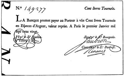
BILL OF THE BANQUE ROYALE OF LAW (1720).
Reduced from a cut in La Croix’s Dix-huitième siècle.
The price of the stock was still further inflated on the market by requiring as a condition precedent for subscriptions to the new issues, that persons desiring to subscribe should be holders of a certain number of shares of the old stock for each share of the new. Subscriptions were in turn stimulated by spreading the payments over a protracted period, on the instalment plan, thus enabling persons of small capital who wished to profit by the upward movement of the stock to operate on margins. To the competition fostered by these ingenious and at that time novel devices was now added the pressure for new shares on the part of those whose investments had been disturbed by the redemption of the rentes. Their demand that some favor be shown them in the matter of subscriptions was recognized, and edicts were issued which removed the stipulation that payments should be made in coin or bank-notes; and in their place billets d’état, notes of the common treasury, and orders on the cashier of the Company given in liquidation of Government[35] obligations, were ordered to be received. Shares rose to ten thousand francs,[50] and even higher; and those who paid for original shares in discredited billets d’état could now realize forty times their purchase-money. The temptation to those of conservative disposition to realize their profits and convert them into coin or property now burst the bubble. For a time the Company, by purchasing its own stock, was able to check the impending disaster; but in spite of all efforts of this sort, and notwithstanding edict after edict ordaining the compulsory circulation of the notes and demonetizing gold and silver, the bank, which had in the mean time been placed under control of the Company, collapsed. The promoter of the scheme, in the same year that he was controller-general of the finances of France, was a fugitive and almost a pauper.
During the progress of these events Louisiana had become the scene of active emigration, ludicrously small when compared with its great domain, but active beyond any preceding movement of population on the part of the French. On the 9th of February, 1718, three vessels despatched by the Company arrived at Dauphin Island, bearing troops and colonists, and also conveying to Bienville[51] the welcome news that he was appointed commandant-général. In September, 1717,[52] Illinois had been detached from New France and incorporated with Louisiana. Boisbriant, who was appointed to the command of that province, did not assume the government until the fall of 1718. The Company set to work honestly to develop the resources of the country. Engineers were sent over to superintend the construction of public works. The pass at the mouth of the river was to be mapped, and two little towers were ordered to be erected “at the entrance to the river, sufficiently high to be seen from afar during the day, and upon which fire can be made at night.” The coast was to be surveyed, and orders were given to effect a landing at St. Joseph’s Bay, — a step which was taken only to be followed by its prompt abandonment. Concessions were made to many distinguished men in France, with conditions attached to each that a certain number of colonists should be imported. Unfortunately for the influence of these grants upon the future of the colony, it was not required that the grantees themselves should live upon their concessions. The grant to Law, twelve miles square, was situated on the Arkansas River. By[36] agreement, he undertook to introduce fifteen hundred settlers. Vessels began now to arrive with frequency, bringing involuntary as well as voluntary emigrants. The power of the courts in France was invoked, apparently with success, to secure numbers for Louisiana, without regard to character. Vagrants and convicts, considered dangerous for French society, were thought suitable for colonists. These steps were soon followed by complaints from the colony of the worthlessness of such settlers and of the little reliance that could be placed upon them in military service.[53] Raynal, in his vigorous way, characterizes them as “the scum of Europe, which France had, as it were, vomited forth into the New World at the time of Law’s system.”
The new commanding general sent a force of mechanics and convicts in February, 1718, to clear the territory now occupied by the city of New Orleans, and to lay the foundations of a new settlement.[54] The channel at Dauphin Island having been blocked by a storm, the headquarters of the colony were removed, first to Old Biloxi, and afterward by order of the Company in 1719, to New Biloxi. During the fall of 1718 MM. Benard de la Harpe and Le Page du Pratz, whose names are associated with the annals of Louisiana, both arrived in the colony. The pages of the chroniclers of colonial events are now sprinkled with the names of ships which arrived with troops and emigrants, including young women from the hospitals and prisons of Paris. On the 6th of June, 1719, two vessels arrived direct from the coast of Guinea with “five hundred head of negroes.” The Company had entered with fervor upon the performance of the stipulation imposed by the charter.
The news of the war between France and Spain reached the colony in the spring of 1719. The inconvenience of the roadsteads occupied by the French had made them anxious to possess Pensacola. Iberville had urged upon the Government the necessity of procuring its cession from Spain if possible. So forcible were his arguments that negotiations to that end had been opened by Pontchartrain.
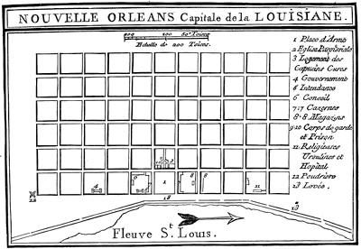
Although the settlement had been neglected by the Spanish Government, yet the proposition to cede it to France was rejected with pompous arguments, in which the title of Spain was asserted as dating back to the famous Bull of Alexander VI., dividing the newly discovered portions of the world between Spain and Portugal.[56] Upon receipt of the news of hostility between the two nations, Bienville promptly availed himself of the opportunity to capture the place.

[This is the “Plan de la Nouvelle Orléans” (1718-1720) in Dumont’s Mémoires historiques de la Louisiane, ii. 50, made by Le Blond de la Tour and Pauger. A plan signed by N. B[ellin] in 1744, “Sur les manuscrits du dépôt des chartes de la marine,” was included in Charlevoix’s Nouvelle France, ii. 433, and reproduced in Shea’s translation, vi. 40. In November, 1759, Jefferys published a “Plan of New Orleans, with the disposition of its quarters and canals as they have been traced by M. de la Tour in the year 1720.” He inserted this map (which included also a map of the lower Mississippi) in the History of the French Dominion in America (London, 1760), and in the General Topography of North America and West Indies (London, 1768). — Ed.]
The episodes of the capture of Pensacola by the French, its recapture by the Spaniards, the desertion of a large part of the French garrison, the successful resistance of Sérigny to the siege of Dauphin Island by a Spanish fleet, the opportune arrival of a French fleet, and the capture again of Pensacola, furnished occupation and excitement to the colonists for a few months, but had no[39] other result. The port was returned to Spain when peace was restored.[57] For several years the French at Natchitoches, and the Spaniards a few miles off at the Mission of the Adaes, had lived peacefully side by side. The French lieutenant in command of the post took advantage of the outbreak of hostilities to destroy the Spanish Mission. It was, however, immediately reoccupied by the Spaniards in force, and was permanently retained by them. In Illinois, through the arrival of a band of Missouris who had come to chant the calumet bedecked in chasubles and stoles, and tricked out in the paraphernalia of the altar, Boisbriant learned that a Spanish expedition from Santa Fé, in 1720, had been completely annihilated by these savages.
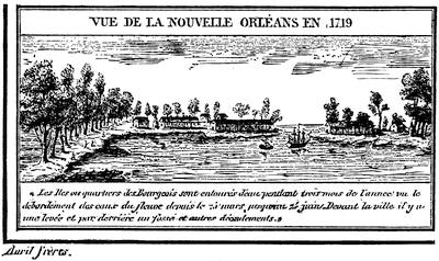
NEW ORLEANS IN 1719.
[This is reproduced from plate ii. of Thomassy’s Géologie pratique de la Louisiane. There is another cut in Gay’s Popular History of the United States, ii. 530. To M. de Vallette Laudun, or Laudreu, sometimes referred to as the Chevalier de Bonrepos, is ascribed the authorship of a Description du Mississipi, écrite de Mississipi en France à� Mademoiselle D. ... (Paris, 1720), the writer being the captain of the ship “Toulouse.” It was reprinted as Relation de la Louisiane, écrite à� une dame par un officier de marine, in the Relations de la Louisiane et du fleuve Mississipi, published at Amsterdam in 1720, which corresponds to vol. v. of Bernard’s Recueil des voyages au nord. It was reprinted as Journal d’un voyage à� la Louisiane fait en 1720 par M. ..., capitaine de vaisseau du roi, both at Paris and La Haye in 1768 (Carter-Brown, vol. iii. nos. 280, 1,641). — Ed.]
Far more important in their effect upon the prosperity of the colony than any question of capture or occupation which arose during these hostilities were the ordinances passed by the Company of the West, on the 25th of April, 1719, in which were announced the fixed prices at which supplies[40] would be furnished to inhabitants at different points, and the arbitrary amounts that would be paid at the same places for peltries, tobacco, flour, and such other articles as the Company would receive. Gayarré summarizes the condition of the colonists under these rules as follows: “Thus the unfortunates who were sent to Louisiana had to brave not only the insalubrity of the climate and the cruelty of the savages, but in addition they were held in a condition of oppressive slavery. They could only buy of the Company at the Company’s price. They could only sell to the Company for such sum as it chose to pay; and they could only leave the colony by permission of the Company.” Whites brought from Europe and blacks brought from Africa “worked equally for one master,— the all-powerful Company.”
Through a title based upon La Salle’s occupation in 1685, strengthened by the explorations of Bienville and Saint-Denys in 1700, the subsequent journeys of Saint-Denys in 1701, 1714, and 1716, and the occupation of Natchitoches, the French laid claim to a large part of what now constitutes Texas. Benard de la Harpe left Dauphin Island toward the end of August, 1718, with fifty men, to establish a post on his concession at Cadodaquais. He settled on land of the Nassonites, eighty leagues in a straight line from Natchitoches. He was instructed to open up trade with the neighboring Spaniards, and through him Bienville forwarded a letter to the Spanish Governor. A correspondence ensued between La Harpe and the Governor at Trinity River, in which each expressed doubts as to the right of the other to be where he was. La Harpe closed it with an assurance that he could be found in command of his fort, and could convince the Governor that he knew how to defend it. No overt act followed this fiery correspondence, and La Harpe shortly after went on an extended tour of exploration to the northward and westward of his concession. We hear no more of this post from French sources; but Spanish authorities assert that after the Mission at Adaes was broken up, the Spaniards returned with an armed force and the French retired to Natchitoches. That post was then put under charge of Saint-Denys. Great stress was laid at Paris upon the necessity for occupying the coast to the west of the mouth of the Mississippi, and positive orders had been issued to that effect by the King on the 16th of November, 1718. Nothing was done, however, until 1720, when six men were landed one hundred and thirty leagues west of the Mississippi and left to perish. In 1721 these orders were reiterated, and La Harpe was appointed “commandant and inspector of commerce of the Bay of St. Bernard.” On August 16 he sailed to take possession of that bay. His equipment and his force were totally inadequate for the purpose. He made a landing at some point on the coast; but finding the Indians hostile, he was obliged to abandon the expedition. With this futile attempt all efforts on the part of the French to occupy any point on the coast of Texas ceased. On the other hand, they remained in uninterrupted possession of Natchitoches;[58][41] and the Spaniards, though they continued to occupy Adaes as long as the French were at Natchitoches, never renewed their attempts on the region of the Osage and the Missouri.

NEW ORLEANS AND THE MISSISSIPPI.
[This is a part of the “Carte de la Côte de la Louisiane, par M. de Sérigny en 1719 et 1720,” as given in Thomassy’s Géologie pratique de la Louisiane, 1860. — Ed.]
During the year 1721 the mortality of the immigrants on the passage over seriously affected the growth of the colony. Among other similar records it is reported that in March two vessels arrived, having on board forty Germans, — all that remained out of two hundred. The same month the “Africaine” landed one hundred and eighty negroes out of two hundred and eighty on board when she sailed, and the “Duc du Maine” three[42] hundred and ninety-four out of four hundred and fifty-three. The pains of the poor creatures did not end with the voyage. Some of them “died of hunger and suffering on the sands of Fort Louis.” Enfeebled by the confinement and trials of a protracted ocean voyage, immigrants and slaves alike were landed on the beach at Biloxi, where neither suitable food nor proper shelter was furnished them.[59] Indeed, so great was the distress for food in 1721, that the very efforts put forth to increase the population were a source of embarrassment and suffering. There were not provisions enough left at Biloxi in September to maintain the garrison; and once again, after more than twenty years’ occupation by the French, the troops at Biloxi were dispersed among the Indians for subsistence.
The engineers who were watching the action of the Mississippi kept a record of their soundings. They attributed the changes which they observed to the scouring action of the water, and suggested methods[60] for keeping up the strength of the current by restraining the river within limits. Their observations confirmed Bienville in the opinion that New Orleans could be reached directly by vessel; thus avoiding the wretched anchorage, fifteen miles from shore,[61] and the expensive and troublesome transfer from ship to barge, and from barge to boat, only to effect a landing by wading, at a spot which was still several days of difficult travel from the natural highway of the country.
The news of the collapse of the Royal Bank and of the flight of Law reached the colony in June, 1721. The expectation that the troubles of the mother country would react upon the fortunes of the colony created great excitement; but the immediate result fell short of the anticipation. Affairs in the territory of Law’s concession were in great confusion. The Alsatians and Germans whom he had placed upon it, finding themselves neglected and the future of the grant doubtful, came down to New Orleans in the expectation of being sent back to Europe. The colony did not willingly relinquish its hold on any of its settlers. These industrious laborers, who had been imported to till the soil, were placated by the grant of concessions along the Mississippi at a point about twenty miles above New Orleans. By their skill in market-gardening they secured the control of that business in the little town which almost in spite of the Company had sprung up on the banks of the river. Bienville, supported by Pauger, one of the engineers, had for some time favored New Orleans as headquarters. The views of the Company on this point had fluctuated. In 1718 the instructions were, to try to open the river to vessels. In 1720 Ship Island, the Alibamons, and the Ouabache (Ohio) were the points they proposed to fortify. In 1721 Pauger prepared a plan for the proposed city of New Orleans. At that time there were only a few cabins there. It was necessary to[43] cut down brush and trees to run the lines. Settlers were attracted by these proceedings, but jealousy stopped the work for a while. Charlevoix, who visited the place in 1722, says that the transfer of the stores of the Company from Biloxi to New Orleans began about the middle of June of that year.
The “Aventurier” arrived in the roadstead in the latter part of May, 1722, bringing orders to make New Orleans the principal establishment of the colony. She was taken up the river by the engineers La Tour and Pauger, and orders were given that all ships should thereafter enter the Mississippi. The “Aventurier” reached New Orleans July 7, and on the 5th of August the departure of Bienville from Biloxi for New Orleans is recorded.
Exchange and currency had proved to be serious drawbacks to the prosperity of Canada. Louisiana was destined to undergo a similar experience. Paper money and card money were issued by the Company. Arbitrary ordinances requiring the presentation of these bills for redemption within a stated time were suddenly promulgated. The price at which the silver dollar should circulate was raised and lowered by edict. Copper money was also forced into circulation. The “Aventurier” had some of this coin on board when she made her famous trip to New Orleans. It was imported, conformably to the edict of June, 1721. The inhabitants were enjoined to receive it without demur, as the Company would take it on the same terms as gold and silver.
To provide for the adjustment of disputes, the colony was divided into nine districts, and judicial powers were conferred upon the commanders of the districts. The jurisdiction of the Superior Council was made exclusively appellate. A similar appellate court, subordinate, however, to the Superior Council, was provided for Illinois.
By ordinance issued May 16, 1722, by the commissioners of the Council, with consent of the Bishop of Quebec, the province of Louisiana was divided into three spiritual jurisdictions. The first comprised the banks of the Mississippi from the Gulf to the mouth of the Ohio, and included the region to the west between these latitudes. The Capuchins were to officiate in the churches and missions of this district, and their Superior was to reside in New Orleans. The second district comprised all the territory north of the Ohio, and was assigned to the charge of the Jesuits, whose headquarters were to be in Illinois. The district south of the Ohio and east of the Mississippi was assigned to the Carmelites. The residence of their Superior was ordinarily to be at Mobile. Each of the three Superiors was to be a grand vicar of the Bishop of Quebec.
By ordinance of the Bishop of Quebec, issued Dec. 19, 1722, the district of the Carmelites was added to that of the Capuchins. The Carmelites then returned to France. In the month of December, 1723, the northern boundary of this district was changed to Natchez, and all the country north of that point, to the east and to the west, was put under charge of the Jesuits.
On the 27th of June, 1725, the Company, to allay the fears of the Capuchins, issued a new ordinance, in which they declared that the Capuchins alone should have the right to perform ecclesiastical functions in their district, and that no priest or monk of other brotherhood should be permitted to do so except with their consent. By request of the Capuchins, this was confirmed by patent from the King, dated the 25th of July, 1725.
The Capuchins had neither the numbers nor the influence essential for so great a work. For this reason the Company assigned the care of the French posts of the district to the Capuchins, and the charge of the Indian missions to the Jesuits; and an agreement was made, Feb. 26, 1726, with the Jesuit fathers, in which the latter undertook to furnish missionaries for the required work. In consequence of this arrangement it became necessary for the Jesuits to have an establishment in New Orleans. Permission to have such establishment was granted by the Company, on condition that they should exercise no ecclesiastical function except by consent of the Capuchins. Beaubois, the Jesuit Superior, disregarded this injunction, and undertook to override the Capuchins, who would have returned to France if he had not been recalled.
On the 13th of September, 1726, the Company entered into a contract with the Ursulines, in which the latter agreed to provide six nuns for the hospital and to educate the girls of New Orleans. The nuns, who were furnished in pursuance of this agreement, sailed from France Feb. 23, 1727. After a perilous voyage, five months in length, they arrived at New Orleans and at once entered on their work.
In 1724 the accumulated complaints of the several officers with whom Bienville had come into collision produced his downfall. La Harpe came to his rescue in a memorial upon the importance of the country and the necessity of maintaining the colony. Louisiana was not to be held responsible for frauds on the Company, nor for lack of system and bad management in its affairs. The Company itself had “begun by sending over convicts, vagrants, and degraded girls. The troops were made up of deserters and men indiscriminately picked up in the streets of Paris. The warehouses were openly robbed by clerks, who screened their knaveries by countless false entries. Disadvantageous bargains were made with companies of Swiss and Germans, of miners, and manufacturers of tobacco,[62] which turned out absolutely without value because the Company did not carry them out. A vast number of burdensome offices were created. The greater part of the directors who were sent out thought only of their own interests and of how they could thwart M. de Bienville, a man more familiar with the country than they were. If he proposed to bring ships[45] up the river, they obstinately opposed him, fearing that they would then no longer be able to maintain traffic with the Spaniards and thus amass fortunes.” La Harpe’s interposition may have subsequently influenced opinions as to Bienville’s merits, but at the time it had no apparent result. In February, 1724, Bienville received positive orders to return to France. The brief interval which elapsed before he sailed gave him an opportunity to associate his name with the issue of the harsh and arbitrary code of fifty-four articles regulating the conduct of the unfortunate slaves in the colony, and imposing penalties for violations of law.
On his return to France, Bienville presented a memorial in vindication of his course. Eight years before this he had urged upon the Marine Council that he was entitled to promotion. The recapitulation of his services, with which he opened his letter, is used again in substance in the memorial: “For thirty-four years Sieur de Bienville has had the honor of serving the King, twenty-seven of them as lieutenant du roy and as commandant of the colony. In 1692 he was appointed midshipman. He served seven years as such, and made seven sea-voyages in actual service on armed vessels of the navy. During these seven years he participated in all the combats waged by his brother, the late Sieur d’Iberville, upon the shores of New England, at Newfoundland, and at Hudson’s Bay; and among others in the action in the North against three English vessels. These three vessels, one of which had fifty-four guns and each of the others forty-two, attacked the said Sieur d’Iberville, then commanding a frigate of forty-two guns. In a combat of five hours he sank the fifty-four-gun ship, and took one of the others; while the third, disabled, slipped away under cover of the night. The said Sieur de Bienville was then seriously wounded in the head.” [63] He then refers to his services in the exploring expedition and in the colony, closing with the statement that his father was killed by the savages in Canada, and that seven of his brothers died in the French naval service.
In support of his memorial, and to refute statements that there would be an Indian outbreak if he should return, several representatives of the Indian tribes of the colony, moved thereto by Bienville’s relatives, were admitted to an audience with the Superior Council, and there pronounced themselves friendly to him. It was thus that the red men, on whom he had relied for food at some time in nearly every year since he landed in Louisiana, rewarded him for his friendly interest in their behalf, — him who had been the advocate of the plan for exiling them to Santo Domingo, there to be exchanged for negroes; who had subdued the eight hundred warriors of the Natchez by treacherously seizing and holding their principal chiefs; who, on the 1st of February, 1723, wrote that an important advantage over the Chickasaws had been gained without the loss of a French life, “through the care that I took to set these barbarians against each other.”

All efforts of Bienville for reinstatement were thrown away. The Council were of opinion that much of the wrangling in the colony was due to the Le Moynes. M. Périer was appointed governor; and in order that his administration might have a fair chance, several of Bienville’s relatives were deprived of office in the colony. Under the new Government, events moved on as before. The quiet of colonial life was undisturbed except for the wrangling of the officials, the publication of company orders, and the announcement of royal edicts. In a memorial forwarded by the commander of Dauphin Island and Biloxi, a highly colored picture is shown of the chaotic condition of affairs. “The army was without discipline. Military stores and munitions of war were not protected. Soldiers deserted at pleasure. Warehouses and store-ships were pillaged. Forgers, thieves, and murderers went unpunished. In short, the country was a disgrace to France, being without religion, without justice, without discipline, without order, and without police.”
Bienville had steered clear of serious Indian complications. He had settled by deceit, without a blow and almost without troops, what in place of more stirring events had been called the “first war of the Natchez.” On the occasion of a second collision, in 1723, he had simply appeared upon the scene with a superior force, and dictated terms to the natives. During Périer’s term of office signs of uneasiness among the natives and of impending trouble began to show themselves. Warnings were given to several of the inhabitants of Natchez that danger was to be apprehended from the neighboring tribe. The commander of the post wilfully neglected these warnings, which were repeatedly brought to his knowledge. On the 29th of November, 1729, the Natchez Indians rose, and slaughtered nearly all the male inhabitants of the little French village.[64] The scene was attended with the usual ingenious horrors of an Indian massacre. A prolonged debauch succeeded. The Yazoos, a neighboring tribe, surprised and slaughtered the little garrison which held the post in their country. Even the fathers in charge of the spiritual affairs of the posts were not spared.[65] Except for this uprising of the Yazoos, the example of the Natchez tribe was not contagious. News was quickly conveyed up and down the river, and but little damage happened to travellers between Illinois and Louisiana.

FORT ROSALIE.
[“Plan du Fort Rozalie des Natchez,” in Dumont’s Mémoires historiques de la Louisiane, ii. 94. There is also a plan of Fort Rosalie in Philip Pittman’s Present State of European Settlements on the Mississippi (London, 1770), p. 40. — Ed.]
According to Dumont, the Choctaws and Natchez had conspired to attack the French simultaneously at New Orleans and Natchez, and the attack at Natchez was made in advance of the day agreed upon for the outbreak. At this, he says, the Choctaws were exasperated, and announced that they were willing to move in conjunction with the French upon Natchez. According to their own professions, however, their friendship[48] for the French was uninterrupted, and they denied any previous knowledge of the outbreak at Natchez. Whatever the motive which prompted it, a joint military campaign against the Natchez was now organized with the Choctaws. All the credit in the affair was gained by the Indians. They were first in the field, and they did all the open fighting. When the French tardily arrived on the spot, instead of the surprise, the sudden attack, the rapid flight, and the complete victory or defeat which had hitherto characterized most Indian warfare, they found the Natchez behind rude fortifications, within which they had gathered all their people, together with the women and children captured at the recent attack on the village. The French were compelled to approach these defences with all the formalities of a siege. At the end of what Périer bombastically terms “six days of open trenches and ten days of cannonade,” the Natchez on the 26th of February, 1730, surrendered the captive women, children, and slaves to the Choctaws, withdrew their entire force, and fled to the opposite bank of the Mississippi. The knowledge that the French captives were with the Indians probably hampered the French in their attack.
The services of tribes friendly to the French were secured during the summer to harass the miserable Natchez; and on the 1st of August the Governor could proudly report that by this means he had been able since their migration to kill a hundred and fifty. “Lately,” he says in one of his despatches, “I burned four men and two women here, and the others I sent to Santo Domingo.” Smarting under the disgrace cast upon their reputation by the fruitless results of this campaign, the French felt the necessity for subduing the fugitive Natchez, who still preserved their tribal organization and their independence. An alleged negro insurrection the next summer furnished opportunity for hanging “ten or a dozen of the most culpable” of the negroes, and further demonstrated the necessity for some attempt to recover the prestige of the French name.
In the month of November, 1730, Périer started on a crusade against his foes. The force which he ultimately brought together for this expedition is said to have been a thousand men, of whom seven hundred were French. In January, 1731,[66] he succeeded in running down the Natchez in their fort, situated a short distance from the river on the west side, where he besieged and finally captured — according to his own account — four hundred and fifty women and children and forty-five men. Again the greater part of the warriors of the tribe escaped him. The captives were sent to Santo Domingo, where they were sold as slaves.
The resources of the colony were now better understood. Buffalo-wool, pearls, and mines were no longer relied upon. Prosperity had eluded the grasp of the greater part of the settlers; but if agricultural experiments had not proved remunerative as they had been handled, they had at least[49] demonstrated the fertility of the soil. The hopes of commercial success, with so scant a population and under the restrictions of the monopoly, were shown to be delusive. The climate had proved a severe trial to the health of the settlers.[67] Perhaps the character of the immigrants, their improvident habits, and their reckless exposure had much to do with it, and had made the test an unfair one. At all events the experience of the Company was but a repetition of that of Crozat; and in 1731 the rights granted in the charter were surrendered to the King. During Périer’s administration a change was made in the character of the girls sent over to the colony. In 1728 there arrived a ship bearing a considerable number of young girls who had not been taken from the houses of correction. They were cared for by the Ursulines until they were married.
It is not easy to follow the growth of the colony. When Crozat turned matters over to the Company, there were said to be seven hundred inhabitants; but four years afterward the Company officials, in one of their reports, put this number at four hundred. The official estimate in 1721 was five thousand four hundred and twenty, of whom six hundred were negroes. La Harpe, in his memorial, puts the population in 1724 at five thousand whites and three thousand blacks. At the time of the retrocession to the King the white population was estimated at five thousand, and the negroes at over two thousand.
The treasury notes of the Company at that time constituted the circulating medium of the colony. Fifteen days were allowed, during which their use could be continued. After that their circulation was prohibited, with appropriate penalties.
The Government signalized its renewal of the direct charge of the colony by efforts to build up its commerce. Bienville succeeded in securing his appointment as governor, and in 1733 returned to Louisiana. The finances of the colony having undergone the disturbance of the withdrawal of the paper money of the Company, the Government consulted the colonial officers as to issuing in its place some card money. These gentlemen recommended that the issue should be postponed for two years. The impatience of the Government could, however, be restrained but a year, when the entering wedge of two hundred thousand livres was ordered, — the beginning of more inflation. In 1736 Bienville, owing to the unfriendly attitude of the Chickasaws, felt the necessity of success in some movement against them, if he would retain the respect and friendship of the Choctaws. He therefore made an imposing demonstration against the Chickasaw villages. According to his own account, he had with him over twelve hundred men, who in an attack on one of the villages were repulsed with such severe loss that the whole party were glad to get back to the shelter of their permanent forts, without the satisfaction of knowing that they had either killed or wounded one of the enemy.
The Chickasaws had apparently learned the value of earthworks as defences, from their experience, if not from the English traders. Some of these traders were in the village at the time of the attack, and hoisted the English flag over their cabins. By throwing up the earth around their houses, the Indians had converted each habitation into a fortification. Unfortunately for the objects of the expedition, Bienville learned, on his return to Mobile, that a coöperating column, organized in Illinois, and composed mainly of Northern Indians, which had marched under young Artaguette against the same enemy, had been completely worsted, and their leader was reported killed.
If the movement against the Chickasaws was demanded by the condition of affairs before this demonstration, the repulse made a renewal of it at an early day a positive necessity. A strong force of men was sent over from France under an officer trusted by the Court, and in 1739 an advance was made with twelve hundred white soldiers and twenty-four hundred Indians, by way of the Mississippi instead of the Tombigbee. They were joined at a point near the present site of Memphis by a company under Céloron, and by a detachment from Fort Chartres under Buissonière. Five months were consumed in exploring a road which was supposed to have been already laid out before they started. During this time all the provisions of the expedition were consumed, and the main army was obliged to return without having seen the enemy. The extensive preparations for the expedition had, however, a moral effect. In March a company of Canadians and Northern Indians, which had reported at the appointed rendezvous, penetrated alone to the Chickasaw villages. The chiefs of that tribe, believing that this corps was supported by the expedition, sued for peace, which the French gladly granted them.
Every military effort put forth by Bienville since his return to Louisiana had resulted disastrously. The old story of accusation and counter-accusation between the resident officials of the colony continued during his second term as before. Chagrined at his lack of success, and mortified by evident distrust of his abilities shown by the Court, he tendered his resignation and pathetically wrote: “If success proportionate to my application to the business of the Government and to my zeal in the service of the King had always responded to my efforts, I should gladly have consecrated the rest of my days to this work; but a sort of fatality has pursued me for some time, has thwarted the greater part of my best-laid plans, has often made me lose the fruit of my labors, and perhaps, also, a part of the confidence of Your Highness.” On the 10th of May, 1743, he was relieved by the Marquis de Vaudreuil, and he then returned to France. He was at that time sixty-two years of age, and never revisited the scene of nearly forty-four years of active life in the service of the Government. He was called the “Father of the Colony,” and a certain romantic affection attaches to his memory, based rather upon his professed good-will than upon any success shown in his management of affairs.
During the remainder of the life of the colony, under the administration of M. de Vaudreuil until he was called to Canada, and after that under M. de Kerlerec, his successor, there was no material change in the condition of affairs. All attempts at recapitulation of events resolve themselves into dreary reiterations of what has already been told again and again. Tobacco and rice continued to be the staple products of the colony. Hopes were still maintained that something might be made by cultivating the indigo-plant. The sugar-cane was introduced in 1751.
There was more of tampering with the currency. Incredible as it may seem, there was scarcity of provisions at this late day, and appeals to France for food.[68] The friendly Choctaws were again incited to war against their traditional enemies, the Chickasaws, and strife was also stirred up among themselves. Another warlike expedition boldly marched to the Chickasaw villages and came back again. Criminations and recriminations between governor and commissaire-ordonnateur continued to the end, with few intermissions and with as lively a spirit as characterized the fiercest days of Bienville’s chronic fights. There was another shipment of girls as late as 1751. The character of the troops remained as before, and deserters continued to be a source of annoyance. Even the children of the colonists were affected by their surroundings, if we may believe an anonymous writer,[69] who says, “a child of six years of age knows more of raking and swearing than a young man of twenty-five in France.”
Illinois, separated from the cabals of the little courts at Quebec and New Orleans, showed some signs of prosperity.[70] In 1711 Father Marest wrote: “There was no village, no bridge, no ferry, no boat, no house, no beaten path; we travelled over prairies intersected by rivulets and rivers, through forests and thickets filled with briers and thorns, through marshes where we plunged up to the girdle.” The character of the returns expected by the French from this country had been shown by the expeditions of Le Sueur and La Mothe Cadillac. A few boat-loads of green earth had been sent to France by Le Sueur for assay, but no mines were opened. La Mothe brought down a few specimens of silver ore which had been found in Mexico, and some samples of lead from the mines which were shown him fourteen miles west of the river; but he discovered no silver mines. Nevertheless, the Company had great faith in this region. Their estimate of the dangers to which it was exposed may be gathered from the instructions to Ordonnateur Duvergier in the fall of 1720. He was told where the principal fortifications were to be maintained. Illinois, the directors said, being so far inland, would require a much smaller fort. Communication was to be opened up with that post by land. Positive commands were given to hold a post on the Ohio River, in order to occupy the territory in advance of[52] the English, and prevent them from getting a foothold there. “Illinois is full of silver, copper, and lead mines, which ought to produce considerable returns if worked. The Company has sent to the colony a number of miners to open the mines and to begin work there as an example to the owners of concessions and to the inhabitants. The troop of Sieur Renault, composed of people accustomed to work of this sort, went to the colony at the same time; but the two troops, according to last reports, are not yet at Illinois.”
About the same time it was ordered that “the establishment made by Boisbriant,” originally a few leagues below the village of the Kaskaskias, but apparently afterward transferred to a point about the same distance above the village, should be “called Fort de Chartres.” [71]
In 1721 Charlevoix traversed this region. Speaking of the so-called fort at St. Joseph, near the foot of Lake Michigan, he says: “The commandant’s house, which is but a sorry one, is called a fort from its being surrounded with an indifferent palisade, — which is pretty near the case with all the rest.” The route of Charlevoix was up the St. Joseph across a portage to the Kankakee, and down that river, the Illinois, and the Mississippi, to Fort Chartres, the next French station which he mentions.[72] He describes it as standing about a musket-shot from the river. He heard of mines both copper and lead. Renault, or Renaud, as he is generally called, who was working the lead mines, still hoped for silver. Even after this we hear occasionally of alleged mineral discoveries and revived hopes of mines; but neither the Company nor the Government were destined to reap any great revenue from this source.
The duties of Boisbriant and of his successors were almost exclusively limited to adjudicating quarrels, administering estates, watching Indians, and granting provisional titles to lands or setting off rights in the common fields of the villages. The history of these years is preserved in fragments of church-registers, in mouldy grants of real estate, or in occasional certificates of marriage which have by chance been saved. No break occurred in this monotony till the joint movement against the Chickasaws, of young[53] Artaguette from Fort Chartres and of Vinsennes from his post on the Wabash in 1736. The troops from these posts, who were to move from the North at the same time that Bienville should approach from the South, following their orders, met and advanced at the appointed time. Their prompt obedience brought them to the spot in advance of the dilatory Bienville, and enabled the Chickasaws, as has been previously stated, to meet the columns separately and defeat them in detail. A column from this fort was also in the body of troops from the North which co-operated in the second attack on these Indians.
During this uneventful time the little colony grew, and the settlers enjoyed a moderate degree of prosperity. A contented population of about two thousand whites,[73] to whom grants of land had been freely made for purposes of settlement or cultivation, was mainly engaged in agricultural pursuits. Side by side with them the natives were gathered in villages in which were established Jesuit missions. The fertile soil readily yielded to their efforts at cultivation more than they could consume, and each year the surplus products were floated down to New Orleans. Bossu asserted that all the flour for the lower country came from Illinois. Vaudreuil, before leaving the colony for Canada, reported[74] that boats came down the river annually with provisions; but as late as 1744 he still harped on the discovery of new copper and lead mines. Of the real agricultural value of the country there could not at that time have been any just appreciation. As a mining region it had proved to be a failure.

PLAN OF FORT CHARTRES.
[Taken from Lewis C. Beck’s Gazetteer of the States of Illinois and Missouri, (Albany, 1823). The plan was draughted from the ground in 1823. Key: a,a,a, etc., exterior wall (1447 feet); B, gate; C, small gate; D,D, houses of commandant and commissary, 96à�30 feet each. E, well; F, magazine; G,G, etc., barracks, 135à�36 feet; H,H, storehouse and guard-house, 90à�24 feet. I, small magazine; K, furnace; L,L, etc., ravine. Area of fort, 4 acres. — Ed.]
The little fort needed repairs;[75] and La Galissonière, with his usual sagacity, wrote, “The little colony of Illinois ought not to be left to perish. The King must sacrifice for its support. The principal advantage of the country is its extreme productiveness; and its connection with Canada and Louisiana must be maintained.” Apparently the urgency of La Galissonière produced some results. Macarty, the officer who had command of the post at the time of the collision between the French and the English at the headwaters of the Ohio, arrived at Fort Chartres in the winter of 1751-1752. Bossu, who accompanied him, writes from the fort: “The Sieur Saussier, an engineer, has made a plan for constructing a new fort here, according to the intention of the Court. It will bear the same name with the old one, which is called Fort de Chartres.” In January, 1755, Bossu arrived a second time at the post, having in the mean time made a trip to New Orleans. He says: “I came once more to the old Fort Chartres, where I lay in a hut till I could[55] get a lodging in the new fort, which is almost finished. It is built of freestone, flanked with four bastions, and capable of containing a garrison of three hundred[76] men.” The construction of this fort was the final effort of France in the Valley of the Mississippi. It proved to be of even less value than the fortress at Louisbourg, upon which so much money was wasted, for it fell into the hands of the enemy without the formality of a siege. On the other side of the river, Bournion, who in 1721 bore the title of “Commandant du Missouri,” founded Fort Orleans on an island in the Missouri, and left a garrison[77] there, which was afterward massacred. Misère, now known as St. Genevieve, was founded about 1740.
As events drifted on toward the end of the French occupation, the difficulties of the French Government elsewhere compelled the absolute neglect of Louisiana. Kerlerec writes in 1757 that he has not heard from the Court for two years; and in 1761 the French ambassador, in a memorial to the Court at Madrid, states that for four years no assistance had been furnished to the colony. An estimate of the population made in 1745 places the number of inhabitants at six thousand and twenty, of whom four thousand were white. Compared with the number at the time of the retrocession by the Company, it shows a falling off of a thousand whites. It is probable that the white population was even less at a later day. It is not strange that the feeble results of this long occupation should have led the Most Christian King to the determination to present the colony to his very dear and much-loved cousin, the King of Spain, — an act which was consummated in 1762, but not made public at the time. Its influence was not felt until later.
The outline of events in Canada which we have previously traced carried us to a point where the first collision in the Valley of the Ohio between the troops of the two great nations who were contending for the mastery of the northern portion of the continent had already taken place. News of this contest reached New Orleans, and reports of what was occurring at the North served to fill out the Louisiana despatches. From this source we[56] learn that the Chevalier de Villiers,[78] a captain stationed at Fort Chartres, solicited the privilege of leading an expedition to avenge the death of his brother Jumonville, who had been killed by the Virginian force under Washington. The request was granted; and thus the troops from the East and from the West participated in these preliminary contests in the Valley of the Ohio.[79]
It is not within the proposed limits of this sketch to follow in detail the military events with which each of the few remaining years of French domination in America were marked. The death-struggle was protracted much longer than could have been anticipated. The white population of the English colonies is said to have been over ten times greater than that of Canada in 1755; and yet these odds did not fairly express the difference between the contending Powers.[80] The disproportion of the aid which might be expected from the mother countries was far greater. The situation was the reverse of what it had been in the past. England began to show some interest in her colonies. She was prosperous, and the ocean was open to her cruisers. The French experiments at colonization in America had proved a source of expense so great as to check the sympathy and crush the hopes of the Court. The vessels of France could only communicate with her colonies by eluding the search of the English ships widely scattered over the sea. Although no formal declaration of war was made until 1756, England did not hesitate to seize French merchant-vessels and to attack French men-of-war, and she backed the pretensions of her colonists with solid arguments clad in red coats and bearing glittering bayonets. France shipped a few soldiers and some stores to Canada. Some of her vessels succeeded in running the gauntlet of the English cruisers, but more were driven ashore or captured. The native Canadians, more French than Frenchmen themselves, rallied to the support of the Government which had strangled every sign of independent life in their country. Old men and children joined the ranks to repel the invader; and again we have the story repeated of scant crops improperly harvested because of lack of field hands, and thereafter actual suffering for food in this old and well-established colony. The experiences of Braddock and of Dieskau were needed to teach Europeans the value of the opinions of provincial officers in matters of border warfare. Temporary successes during several years inspired hopes in the minds of the French and thwarted the progress of the English. Nevertheless, the strength of the English began to tell, especially along the seaboard, where their supremacy was more conspicuous. The line of French forts across the neck of the Acadian peninsula fell without serious opposition, and it was determined to remove from the country a population which would neither take the oath of allegiance to His Britannic[57] Majesty, nor preserve neutrality in time of war. Their forcible deportation followed; and in their wanderings some of these “neutral French” even penetrated to the distant colony of Louisiana, where they settled on the banks of the Mississippi.[81] Such was the demoralization of the official class of peculators in Canada that those refugees who escaped to the protection of its Government were fed with unwholesome food, for which the King had been charged exorbitant prices by his commissaries. The destruction of the fort at Oswego postponed for that year the efforts of the English to interrupt the communication between the valleys of the Ohio and the St. Lawrence. The destruction of Fort William Henry temporarily protected Montreal; the check sustained by Abercromby was of equal military value. But in 1758 Louisbourg, with its garrison and stores was lost, the little settlements in Gaspé were ravaged, and France was deprived of the last foot of territory on the North Atlantic seaboard. Quebec thus became accessible to the enemy by way of the sea without hindrance.

Distrust and jealousy pervaded the Government councils in Canada. Pierre François, Marquis of Vaudreuil, the successor of Duquesne in 1755, and Montcalm, whose cordial co-operation was essential, were at swords’ points. With each succeeding year the corrupt practices of Intendant Bigot were more openly carried on. With famine stalking through the streets of Montreal and Quebec, with the whole population living on short rations, and bread-stuffs at incredible prices, the opportunity for this wide-awake Intendant to make money was never better. If accounts are to be trusted, he availed himself of his chance; and out of the sufferings and dire necessities of this sorely pressed people he amassed a fortune.[82] All this was to the advantage[58] of England. Every point that she gained in the struggle she kept. From each reverse that she sustained she staggered up, surprised that the little band of half-starved Canadian troops should have prevailed again, but with renewed determination to conquer. The only value of success to Canada was to postpone the invasion, and for the time being to keep the several columns which threatened Montreal from co-operation. With so feeble a force the French could not hope to maintain the widely scattered forts which they held at the beginning of hostilities. In 1759 they were threatened by hostile columns counting more than the entire number of Canadians capable of bearing arms. All hope of aid from France was crushed by the Minister, who wrote: “In addition to the fact that reinforcements would add to the suffering for food which you already experience, it is very much to be feared that they would be intercepted by the English on passage.” Such was the mournful condition of affairs when Wolfe sailed up the St. Lawrence, expecting to find Quebec ready to fall into his hands. To his surprise, the place was held by a force thoroughly capable of defending it against the combined strength of his soldiers and sailors. Fortune favored him, and Quebec was gained.
The resistance of the French during one more campaign was probably justifiable, but was a mere matter of form. Without hope of assistance from France, without means of open communication with any other French possession, without supplies of ammunition or of food, there was really nothing left to fight for. Even the surrounding parishes of Canada had yielded to the pressure of events, after the failure to recapture Quebec. When, therefore, the English columns converged upon Montreal in 1760, the place capitulated, and the French flag disappeared from Canada.
At the mouth of the Mississippi French occupation was not disturbed until the boundaries were adjusted in accordance with the terms of the Treaty of Peace signed at Paris in February, 1763. No reference was made in the treaty nor in the preliminary convention to the fact that France had already granted to Spain her title to the whole of Louisiana. Knowledge of this remarkable act was kept secret for a few years longer. England, by the terms of the treaty of Paris, became the acknowledged mistress of all that portion of the American continent which lies east of the middle of the Mississippi River, with the exception of the island on which was built the city of New Orleans. Ample provision was made to protect the rights of French citizens who might wish to remove from the country. The privilege of religious worship according to the forms of the Roman Catholic[59] Church was guaranteed to those who should remain, as far as the laws of England would permit.
The era of colonial history which this chapter covers is coincident with a period of decline in France. The transmission of the throne in the line of descent was not, however, interfered with, nor were the traditions of colonial policy changed. The causes of the rise and fall of the colonies of European Powers at that time are to be found in the history of European politics; and European politics in turn were largely influenced by the desire to control territory in the New World. The life of French colonies was in close contact with European events. If the pulse of the English settlements did not throb in such sympathy with the mother country, it was because there was a fundamental difference in the methods by which English colonies had been formed and in the conditions of their growth. A colony was not looked upon at that time as forming a part of the parent State. It was a business venture, entered into directly by the State itself, or vicariously by means of a grant to some individual or company. If the colony did not earn money, it was a failure. Spain had derived wealth from ventures of this sort. Other nations were tempted into the pursuit of the same policy in the hope of the same result.
To preserve the proper relations to the parent State, the colony should have within itself elements of wealth which should enrich its projectors; it should absorb the productions of the State which founded it; and in no event ought it to come into competition with its progenitor. The form of the French government was so logical that its colonies could be but mimic representations of France. Priests and nuns, soldiers and peasants, nobles and seigniors, responded to the royal order, and moved at the royal dictation in the miniature Court at Quebec much the same as at Paris. There was so little elasticity in French life that the French peasant, when relieved from the cramp of his surroundings, still retained the marks of pressure. Without ambition and without hope, he did not voluntarily break away from his native village. If transported across the water, he was still the French peasant, cheerful in spirit, easily satisfied, content with but little, and not disposed to wrestle for his rights. The priest wore his shovel-hat through the dense thickets of the Canadian forests, and clung to his flowing black robe even though torn to a fringe by the brambles through which it was trailed. Governor and council, soldier, priest, and peasant, all bore upon their persons the marks that they were Frenchmen whose utmost effort was to reproduce in the wilds of America the artificial condition of society which had found its perfect expression in Versailles. Autocratic as was Frontenac, unlikely as he was to do anything which should foster popular notions of liberty, or in any way endanger monarchical institutions, — even he drew down upon himself a rebuke from the Court for giving too much heed to the people in his scheme of reorganization.
From his palace in France the Grand Monarque dictated the size and shape of a Canadian farm. He prescribed the localities which new-comers ought to select. They must not stray too far from villages; they must clear lands in spots contiguous to settlements. He could find men who would go to Canada, but there was no emigration of families. Soldiers in the colony were offered their discharge and a year’s pay if they would marry and settle. Premiums were offered the colonists for marrying, and premiums for children. “The new settler,” says Parkman, “was found by the King, sent over by the King, and supplied by the King with a wife, a farm, and sometimes with a house.” Popular meetings were in such disfavor that not until 1717 were the merchants permitted to establish an exchange at Quebec. His Majesty, while pulling the wires which moved the puppets of European politics, still found time to express his regrets that the “King’s officers had been obliged to come down from Frontenac to Quebec to obtain absolution,” and to convey his instructions to the Bishop of Quebec to suppress several fà�te-days which interfered with agricultural labors. Cared for thus tenderly, it would seem that Canada should have thriven. Had the measures put forth been wisely directed toward the prosperity of the colony, it might have done so; but Louis XIV. was not working for the benefit of Canada; his efforts were exclusively in behalf of France. In 1706 his Minister wrote: “It is not for the interest of the parent State that manufactures should be carried on in America, as it would diminish the consumption of those in France; but in the mean time the poor are not prohibited from manufacturing stuffs in their own houses for the relief of themselves and their families.” Generous monarch! The use of the spinning-wheel and the loom was not forbidden in the log-cabins in Canada, even if this did clash somewhat with French trade. “From this permission,” says Heriot, “the inhabitants have ever since continued to fabricate coarse linen and druggets, which has enabled them to subsist at a very small expense.” Coin was almost unknown much of the time; and the paper money and bills of exchange, upon which the colony depended for a circulating medium, were often seriously depreciated.
The spirit of organization and inquisition which infested the Government pervaded all things temporal and spiritual. Trade in peltries could only be carried on by those having permits from the Government or from the firm or company which for the time being had the monopoly. All trade at outlying posts was farmed out by the governors. Young men could not stray off into the woods without violating a royal edict. Such solicitude could only produce two results, — those who endured it became automatons; those who followed their inclinations and broke away from it were proscribed as bushrangers. From the day when Champlain founded the city of Quebec down to the time when the heroic Montcalm received his death-wound on the Plains of Abraham, the motives which had influenced the French in their schemes of colonization had been uniform and[61] their methods identical. Time enough had elapsed to measure the success of their efforts.
French colonization in America had reached three degrees of prosperity. In Acadia, under English rule, freed from military service in the ranks of the country to which they naturally owed allegiance, and with their rights as neutrals recognized by the English, the French colonists had prospered and multiplied. Originally a band of hunters and fishers, they had gradually become an agricultural population, and had conquered prosperity out of a soil which did not respond except to the hand of patience and industry. Exempt from the careful coddling of His Most Christian Majesty, they had evoked for themselves a government patriarchal in its simplicity and complete for their needs. In Louisiana, under the hothouse system of commercial companies and forced immigration, the failure had been so complete that even those who participated in it could see the cause. In Canada there was neither the peaceful prosperity of Acadia nor the melancholy failure of Louisiana. Measured by its own records, the colony shows steady growth. Compared with its rivals, its laggard steps excite surprise and demand explanation. The Acadians were French and Catholics. Neither their nationality nor their religion interfered with their prosperity. They had, however, been lucky enough to escape from the friendly care of the French Government. It is but a fair inference that the Canadians also would have thriven if they could have had a trial by themselves.
The history of England during the corresponding period showed no such uniform motive, no such continuous purpose as to her colonies. From the time of their foundation the English colonies became practically independent States, with which the Home Government, during the long period of political disturbances which intervened, seldom interfered. The transmission of the crown by descent was interrupted. A parliament displaced and executed a king. A protector temporarily absorbed his power. The regular order of the descent of the crown in the restored royal family was again interrupted. The crowned ruler of England was a fugitive on the Continent, and Parliament by act prescribed who should govern England, and afterward how the crown should be transmitted. The causes that produced English emigration, whether political or religious, varied with these events, and emigration was correspondingly affected; but whatever the extent and whatever the character of this influence, the emigration from England was, as a rule, a voluntary emigration of families. Young men might be tempted by the fascinating freedom of a wild life in the woods; but the typical emigrant was the father of a family. He abandoned a home in the old country. He took with him his wife, his family, and his household goods. Much of the furniture brought over by the sturdy emigrants of that time is still treasured by their descendants. The strong mental individuality which thus led men with families to cut adrift from[62] the struggles and trials in England, only to encounter the dangers and difficulties of pioneer life in a new country, found expression in various ways in the affairs of the colonies, oftentimes to the vexation of the authorities.
The New France was a reproduction of the Old France, with all, and more than all, the restrictions which hampered the growth and hindered the prosperity of the parent State. The New England had inherited all the elements of prosperity with which the Old England was blessed, and had even more of that individuality and freedom of action on the part of its citizens which seems to form so important an element of success. Out of the heterogeneous mixture of proprietary grants, colonial charters, and commissions, some of which were granted to bodies which sought exclusive privileges, while others were based upon broad, comprehensive, and liberal views; out of the conflicting interests and divergent opinions of fugitive Congregationalists, Quakers, and Catholics; out of a scattered, unorganized emigration of men entertaining widely different views upon politics and religion, — these aggressive, self-asserting colonists evolved the principle of the right of the inhabitants to a voice in the affairs of their government; and whether provision was made for it in the charter or not, houses of burgesses, general courts, and assemblies were summoned to make laws for the various colonies. Charters were afterward annulled; laws which contained offensive assertions of rights were refused the royal assent: but the great fundamental truth remained, — that the colonies were self-supporting. They had proved their capacity, and they constantly showed their determination, to govern themselves. Each movement of the emigrant away from the coast became a permanent settlement which required organization and control. Out of the unforeseen and unexpected conditions which were constantly occurring came the necessity for local government, to be administered by officers chosen by the little settlements.
Emerson, in speaking of the first tax assessed upon themselves by the people of Concord in Massachusetts, accounts for the peculiar developments of colonial life in New England in the following words: “The greater speed and success that distinguishes the planting of the human race in this country over all other plantations in history owe themselves mainly to the new subdivisions of the State into small corporations of land and power. It is vain to look for the inventor; no man made them. Each of the parts of that perfect structure grew out of the necessities of an instant occasion; the germ was formed in England.”
The pioneer penetrated the forest; he took with him the school-house and the church. Out of the necessities of instant occasions grew, in New England at least, the town-meeting, — the complete expression of a government whose foundations are laid in the people.
Before leaving the colony, in 1754, the Marquis Duquesne summoned the Iroquois to a council. In the course of an address which he then delivered he said: “Are you ignorant of the difference between the King[63] of England and the King of France? Go, see the forts that our King has established, and you will see that you can still hunt under their very walls. They have been placed for your advantage in places which you frequent. The English, on the contrary, are no sooner in possession of a place than the game is driven away. The forest falls before them as they advance, and the soil is laid bare so that you can scarce find the wherewithal to erect a shelter for the night.” No more powerful contrast of the results in North America of the two methods of colonization could be drawn than is presented in the words of the French Governor.
CRITICAL ESSAY ON THE SOURCES OF LOUISIANA HISTORY.
CHARLEVOIX’ Nouvelle France[83] and the account of his personal adventures in the Journal d’un voyage, etc., have been much quoted by early writers. The extent and value of Dr. Shea’s work in annotating his translation of this history can only be appreciated by careful study. Through this means the translation is more valuable for many purposes of research than the original work.[84]
In 1831 the Journal historique de l’établissement des Français à� la Louisiane was published at New Orleans and at Paris. It consists of an anonymous historical narrative, to which is appended a memorial signed by Benard de La Harpe. It is generally quoted as “La Harpe.” The narrative is founded largely upon the journals of Le Sueur and La Harpe, though it is evident that the author had other sources of information. Within its pages may be found a record of all the expeditions despatched by the colony to the Red River region and to the coast of Texas.[85] The work of compilation was done by a clear-headed, methodical man. Margry quotes from the work, and attributes its authorship to “le Chevalier de Beaurain, géographe du roy.” [86] Manuscript copies of this work, under the title Journal historique concernant l’établissement des Français à� la Louisiane, tiré des mémoires de Messieurs D’Iberville et De Bienville, commandants pour le roy au dit pays, et sur les[64] découvertes et recherches de M. Benard de la Harpe, nommé aux commandement de la Baye St. Bernard, are to be found in some of our libraries.[87]

Following the engraving in Shea’s Charlevoix, vol. i. [but now, 1893, thought to be Le Jeune].
The historians of Canada give but brief and inaccurate accounts of the early history of Louisiana. Ferland repeats the errors of Charlevoix even to the “fourth voyage of Iberville.” Garneau leaves the Natchez in possession of their fort at the end of the first campaign.[88]
Judge François-Xavier Martin, in the History of Louisiana from the Earliest Period, 2 vols. (New Orleans, 1827-1829), followed closely the authorities accessible to him when he wrote; his work is a complete, and in the main accurate, compendium of the materials at his command. A new edition was published at New Orleans in 1882, entitled: The History of Louisiana from the Earliest Period. With a Memoir of the Author by W. W. Howe. To which is appended, Annals of Louisiana from 1815 to 1861, by J. F. Condon.
Charles Gayarré is the author of two distinct works which must not be confounded. Louisiana, its Colonial History and Romance,[89] is a history of colonial romance rather than a history of the colony. The Histoire de la Louisiane[90] is an essentially different book. It is mainly composed of transcripts from original documents, woven together with a slender thread of narrative. He states in his Preface that he has sought to remove from sight his identity as a writer, and to let the contemporaries tell the story themselves. References to Gayarré in this chapter are exclusively made to the Histoire, which was brought down to 1770. His final work (reprinted in 1885) was in English, and was continued to 1861.[91] In this edition two volumes are given to the French domination, one to the Spanish, and one to the American.[92]

A little volume entitled Recueil d’arrests et autres pièces pour l’établissement de la compagnie d’occident was published in Amsterdam in 1720. It contains many of the important edicts and decrees which relate to the foundation and growth of this remarkable Company.
The presence of Le Page du Pratz in the colony for sixteen years (1718 to 1734) gives to his Histoire de la Louisiane[93] a value which his manifest egotism and whimsical theories cannot entirely obscure. It was an authority in the boundary discussions.[94]

MOUTHS OF THE MISSISSIPPI.
[Part of a map in Le Page du Pratz’ Histoire de la Louisiane (1758), i. 139. Cf. also the Carte des embouchures du Mississipi, by N. Bellin, given (1744) in Charlevoix’ Nouvelle France, iii. 442. In the same volume (p. 469) is the “Partie de la coste de la Louisiane et de la Floride,” giving the coast from the mouths of the Mississippi to Apalache Bay. In 1759 Jefferys gave in the margin of his reproduction of La Tour’s map of New Orleans a map of the Mississippi from Bayagoula to the sea, and of the east mouth of the river, with the fort La Balise. — Ed.]
Dumont, whose Mémoires historiques sur la Louisiane[95] were edited by M. L. Le M. (said to have been L’Abbé Le Mascrier), was in the military service in the colony. In the Journal historique, etc., mention is made of a sub-lieutenant Dumont de Montigny[96][67] at the post at Yazoo. The author was stationed at this post, and accompanied La Harpe up the Arkansas. The statement made in biographical works that Butel Dumont,[97] who was born in 1725, was the author, is manifestly incorrect. Both Dumont and Le Page were contributors to the Journal œconomique, a Paris periodical of the day. We are able positively to identify him as Dumont de Montigny, through an article on the manner in which the Indians of Louisiana dress and tan skins, in that journal, August, 1752. Dumont had a correspondence with Buache the cartographer[98] on the subject of the great controversy of the day, — the sea of the west and the northwest passage. Dumont was fond of a good-sounding story;[99] and his book, like that of Le Page depends for its value largely upon the interest of his personal experiences. Another book of the same class is the Nouveaux voyages aux Indes occidentales,[100] by M. Bossu. The author, an army officer, was first sent up the Tombigbee, and afterward attached to the forces which were posted in Illinois, and was there when Villiers marched on Fort Necessity. He was in the colony twelve years, and bore a good reputation.
The work entitled état présent de la Louisiane, avec toutes les particularités de cette province d’Amérique, par le Colonel Chevalier de Champigny (A la Haye, 1776), has been generally quoted as if Champigny were the author. In an editorial introduction Champigny says the text and the notes were furnished him in manuscript by an English officer. In the body of the work the statement is made by the author that he accompanied the English forces which took possession of the colony after its cession to England. This work is cited by Mr. Adams in the boundary discussion.
The Mémoire historique et politique de la Louisiane, by M. de Vergennes, minister of Louis XVI. (Paris, 1802), contains a brief historical sketch of the colony, intended only for the eye of His Majesty. Its wholesome comments on the French troops and on French treatment of the Indians are refreshing to read.[101] They would not have been so frank, perhaps, if the work had been intended for publication.

In his Early Voyages Up and Down the Mississippi (Albany, 1861) Dr. Shea has collected, translated, and annotated various relations concerning the voyages of Cavelier, De Montigny de Saint-Cosme, Le Sueur, Gravier, and Guignas.[102]
A number of the relations in the Lettres édifiantes et curieuses cover portions of the period and territory of this chapter. These have been collected and translated by Bishop Kip in the Early Jesuit Missions (Albany, 1866). To avoid repetition, he has made certain abridgments. Some of the material thus left out has value to the student of the early history of Illinois.[103]
Major Amos Stoddard, in his Sketches Historical and Descriptive of Louisiana (Philadelphia, 1812), furnished an unostentatious and modest book, which has been freely quoted.
The Relation du voyage des dames religieuses Ursulines de Rouen, etc. (Paris, 1872), with an introduction and notes by Gabriel Gravier, is an exact reprint of a publication at Rouen in 1728 of certain letters of Marie Madeleine Hachard, sœur Saint-Stanislas, to her father. The account of the tedious journey of the nuns from Paris to Orient, and of their perilous voyage to New Orleans, was worth preservation. M. Gravier has performed his part of the work with the evident satisfaction which such a task would afford a bibliophile and an antiquary. His introductory chapter contains a condensed history of Louisiana down to 1727, and is strongly fortified with quotations. He acknowledges himself to be indebted to M. Boimare for a great number of valuable unpublished documents relating to the foundation of New Orleans. Greater familiarity with his subject would have enabled him to escape several errors of date and of statement into which he has been led by authorities whose carelessness he apparently did not suspect. The memorial concerning the Church in Louisiana (note 1, p. 113 et seq.) is a document of great value and interest. M. Gravier (p. lvi) states that the Relation is substantially the same as the Relation du voyage des fondatrices de la Nouvelle Orléans, écrite aux Ursulines de France, par la première supérieure, la mère St. Augustin, which was reprinted by Dr. Shea in an edition of one hundred copies in 1859, under the general title of Relation du voyage des premières Ursulines à� la Nouvelle Orléans et de leur établissement en cette ville [1727], par la Rev. Mère St. A. de Tranchepain; avec les lettres circulaires de quelquesunes de ses sœurs, et de la dite mère (62 pp.).
The History of the American Indians, particularly those Nations adjoining to the Mississippi, East and West Florida, Georgia, South and North Carolina, and Virginia, etc., by James Adair, who was forty years in the country, is a work of great value, showing the relations of the English traders to the Indians, and is of much importance to the student of Indian customs.[104]
The Géologie pratique de la Louisiane, by R. Thomassy (New Orleans and Paris, 1860), contains copies of some rare documents which were first made public in this volume.
The Histoire de la Louisiane[105] by M. Barbé Marbois is so brief in its treatment of the period covered by this chapter that very little can be gained from consulting that portion of the book.
A work entitled De la puissance Américaine, by M. Guillaume-Tell Poussin, was published at Paris in 1843. A translation was printed at Philadelphia in 1851. The writer, from his familiarity with this country, was especially fitted to give a French view of our history. His chapter on Louisiana shows that he had access to the treasures of the Paris Archives. Its value, however, is diminished by the fact that he is inexact in his details.
Daniel Coxe, the son of Dr. Coxe, the claimant of the Carolana grant, published in London in 1722 A Description of the English Province of Carolana, by the Spaniards call’d Florida, and by the French La Louisiane.[106] The body of the text is devoted to a description of the attractions of the province to the emigrant. The preface contains an account of the entrance of the Mississippi by the vessel which was turned back by Bienville. The appendix is an argument in favor of the claimant’s title to the grant, and of England’s title to the Mississippi Valley. It contains a curious story of a Massachusetts expedition to New Mexico in 1678, and a claim that La Salle’s guides were Indians who accompanied that expedition.[107]
The official correspondence concerning the Louisiana boundary question may be found in Waite’s American State Papers and Public Documents (Boston, 1815-1819), vol. xii. The temperate statements of Don Pedro Cevallos are in strong contrast with the extravagant assumptions of Luis de Orris, who even cites as authority the mythical Admiral Fonte.[108] Yoakum, in his History of Texas (New York, 1856), goes over this ground, and publishes in his appendix an interesting document from the archives of Bexar.
Illinois in the Eighteenth Century, by Edward G. Mason (Fergus Historical Series, no. 12), Chicago, 1881, has two papers dealing with the topics of this chapter: “Kaskaskia and its parish records” and “Old Fort Chartres.” The recital of the grants, the marriages, and the christenings at Kaskaskia and St. Anne brings us close to Boisbriant, Artaguette, and the other French leaders whose lives are interwoven with the narrative of events in Illinois. The description of Fort Chartres is by far the best extant. The work of rescuing from oblivion this obscure phase of Illinois history has been faithfully performed.
The following works have been freely used by writers upon the early history of Illinois and the Illinois villages and forts:—
The Administration of the Colonies, by Thomas Pownall, 2d ed. (London, 1765). The appendix, section 1, deals with the subject of this chapter.
A Topographical Description of North America, by T. Pownall (London, 1776). Appendix, no. 4, p. 4, Captain Harry Gordon’s Journal, describes the fort and villages.

COXE’S CAROLANA.
[Part of the Map of Carolana and of the River Meschacebe, in Daniel Coxe’s Description of the English Province of Carolana, London, 1742 — Ed.]
Thomas Hutchins has also published two books, — An Historical Narrative and Topographical Description of Louisiana, etc. (Philadelphia, 1784), and A Topographical Description, etc. (London, 1778).
Captain Philip Pittman prepared a report on The Present State of the European Settlements on the Mississippi. It was published in London, in 1770. It is embellished with charts of the river and plans of several of the forts and villages.[109]
Also Sketches of History, Life and Manners in the West, by James Hall (Philadelphia, 1835), who visited the fort in 1829.
The Early History of Illinois, by Sidney Breese, contains an interesting description of French life in Illinois.[110] See also a chapter on the same subject in Davidson and Stuvé’s Complete History of Illinois (Springfield, 1874). The History of the Discovery and Settlement of the Mississippi Valley, by John W. Monette (New York, 1846), also has an elaborate sketch of the settlement of Louisiana and Illinois.[111]
Mississippi as a Province, Territory, and State, by J. F. H. Claiborne (1880), devotes considerable space to the Province.
Extracts from a memoir by M. Marigny de Mandeville may be found in several of the histories of Louisiana of colonial times. In a note in Bossu[112] it is stated that such a work was published in Paris in 1765.
The story of Saint-Denys’ experiences in Mexico is told in H. H. Bancroft’s North Mexican States, p. 612 et seq., in which the sources of information are mainly Mexican and Spanish. The hero of Penicaut’s romances, viewed from this standpoint, becomes a mere smuggler.
Under the title Historical Collections of Louisiana, etc., Mr. B. F. French, in the years 1846-1875, inclusive, published seven volumes containing reprints and translations of original documents and rare books. Mr. French was a pioneer in a class of work the value of which has come to be fully appreciated. His Collections close a gap on the shelves of many libraries which it would be difficult otherwise to fill. The work was necessarily an education to him, and in some instances new material which came to his hands revealed errors in previous annotations.[113] The value of the work would have been increased if abridgments and omissions had been noted.[114] The translation of the Journal[72] historique, etc., given in the collection was made from the manuscript copy in the library of the American Philosophical Society at Philadelphia.[115] The Penicaut relation differs materially from the copy published by Margry.[116] The labors of Mr. French, as a whole, have been of great service to students of American history.[117]
The fourth and fifth volumes[118] of Pierre Margry’s Découvertes et établissements des Français dans l’ouest et dans le sud de l’Amérique septentrionale contain the material upon which so much of this chapter as relates to Iberville’s expeditions is founded. We have here Iberville’s correspondence with the minister, his memorials, the instructions given to him, and his reports.[119] There are also some of Bienville’s despatches, and the correspondence with the engineer about New Orleans and about the bar at the mouth of the river. The publication of these volumes has enabled us to correct several minor errors which have been transmitted from the earlier chroniclers. Interesting as the volumes are, and close as their scrutiny brings us to the daily life of the celebrated explorer, it is not easy to understand why their contents should have been shrouded with such a profound mystery prior to their publication.[120]
The periodicals and tracts of the eighteenth century contain many historical articles and geographical discussions, from which historical gleaners may yet procure new facts.[121] The manuscripts in the Archives at Paris have by no means been exhausted. Harrisse, in his Notes pour servir à� l’histoire, etc., de la Nouvelle France (Paris, 1872), gives an account of the vicissitudes which they have undergone. He traces the history of the formation of the Archives of the Marine and of the Colonies and points out the protecting and organizing care, which Colbert during his ministry devoted through intelligent deputies to the arranging of those documentary sources, among which the modern historian finds all that the Revolution of 1789 has left to him.
The copies which from time to time have been procured from France for the State Archives of Louisiana have so generally disappeared, particularly during the Federal occupation, that but a small portion of them still remains in the State Library.[122]


JOHN LAW.
Copied from the head of a full-length portrait in Het Groote Taferel. Rigaud’s portrait of Law is engraved in Alphonse Courtois’ Histoire des banques en France, 2d ed. (Paris, 1881). Cf. also the print in Mouffle d’Angerville’s Vie privée de Louis XV. (Londres, 1781), vol. 1. p. 53.
I. Law and the Mississippi Bubble. — The literature of the Mississippi Scheme is extensive, and includes the relations of Law’s system to general monetary science. The Mississippi excitement instigated the South Sea Scheme in England. Holland, also, was largely affected, and gave, as well as England and France, considerable additions to the contemporary mass of brochures which grew out of these financial revolutions. Law’s own pleas and expositions, as issued in pamphlets, are the central sources of his own views or pretensions, and are included in the Œuvres de J. Law, published at Paris in 1790. These writings are again found in Daire’s économistes financiers; where will also be met the Essai politique sur le commerce of Melon, Law’s secretary,— a production which Levasseur styles an allegorical history of the system, — and the Réflexions politiques sur les finances et le commerce of Dutot, another of Law’s partisans, who was one of the cashiers of the Company of the Indies, and undertook to correct what he thought misconceptions in Melon; and he was in turn criticised by an opponent[76] of Law, Paris Duverney, in a little book printed at the Hague in 1740, as Examen du livre intitulé, etc.
Law’s proposal for his Mississippi Company is also included in a Dutch collection of similar propositions, printed at the Hague in 1721 as Verzameling van alle de projecten en conditien van de compagnien van assuratie, etc.
There are various Lettres patentes, édits, Arrests, Ordonnances, etc., issued separately by the French Government, some of which are included in a volume published at Amsterdam in 1720, — Recueil d’arrests et autres pièces pour l’établissement de la compagnie d’occident. Others will be found, by title at least, in the Recueil général des anciennes lois Françoises (Paris, 1830), vol. xxi., with the preambles given at length of some of the more important. Neither of these collections is complete, nor does that of Duhautchamp take their place; but all three, doubtless, contain the chief of such documents.
A few of the contemporary publications may be noted: —
Some Considerations on the Consequences of the French settling Colonies on the Mississippi, from a Gentleman [Beresford] of America to his Friend in London, London, 1720 (Carter-Brown, vol. iii. no. 275).
Impartial Inquiry into the Right of the French King to the Territory west of the Mississippi (London, n. d.).
The Chimera; or, the French way of paying National Debts laid open (London, 1720).
Full and Impartial Account of the Company of the Mississippi ... projected and settled by Mr. Law. To which is added a Description of the Country of the Mississippi and a Relation of the Discovery of it, in Two Letters from a Gentleman to his Friend (London, 1720). In French and English (cf. Carter-Brown, vol. iii. no. 276). This is an incentive to the speculation.
Historische und geographische Beschreibung des an dem grossen Flusse Mississippi in Nord America gelegenen herrlichen Landes Louisiana, etc. (Leipsic, 1720) 8vo. It has a map of Louisiana. There was a second edition the same year in 12mo, with Ausfiihrliche beginning a title otherwise the same (Carter-Brown, vol. iii. nos. 277, 278). It has an appendix, Remarques iiber den Mississippischen Actien-Handel, which is a translation of a section on Louisiana in Aanmerkigen over den koophandel en het geldt, published at Amsterdam (Muller, Books on America, 1872, nos. 915, 916; 1877, no. 1817).
Le banquerotteur en desespoir; Das ist, der versweifflende Banquerottirer, etc., with a long explanation in German of the lament of a victim, dated 1720, without place, and purporting to be printed from a Dutch copy (cf. Carter-Brown, ii. 258).
Het Groote Tafereel der Dwaasheid, vertoonende de opkomst, voortgang en ondergang der Actie, Bubbel en Windnegotie in Vrankryk, Engeland en de Nederlanden, gepleegt in dem Jaare DDCCXX. (1720). This is a folio volume of satire, interesting for its plates, most of which are burlesques; but among them are a full-length portrait of Law, another of Mrs. Law in her finery, and a map of Louisiana. There is a copy in Harvard College Library. Cf. Carter-Brown, vol. iii. no. 270; Muller, Books on America (1872), no. 1503.
There is in the Boston Public Library a contemporary manuscript entitled, Mémoire d’après les voyages par Charles Le Gac, directeur de la Comp. des Indes à� la Louisiane, sur la Louisiane, sa géographie, la situation de la colonie Française, du 26 aoust 1718 au 6 mars 1721, et des moyens de l’améliorer. Manuscrit redigé en 1722. Le Gac was the agent of Law’s Company during these years.
The earliest personal sketch which we have noted is a Leven en character van J. Law (Amsterdam, 1722).
A Sketch of the Life and Projects of John Law was published in Edinburgh in 1791, afterward included in J. P. Wood’s Ancient and Modern State of the Parish of Cramond (Edinburgh, 1794), and the foundation of the later Life of John Law of Lauriston, published by Wood at Edinburgh in 1824. This may be supplemented in some points by Chambers’s Biographical Dictionary of Eminent Scotsmen.

Professor Smyth found, when he assigned one of his Lectures on Modern History (no. 27) to Law and his exploits, that he got at that time the best exposition for his system in English from Steuart’s Political Economy. The latest summarized statement in English will be found in Lalor’s Cyclopadia of Political Science, vol. ii. (1883), and a good one in Mackay’s Popular Delusions. The general historians of England, more particularly Stanhope, do not tell the story of the great imitatory pageant of the South Sea Scheme without more or less reference to Law. Those of the United States necessarily recount the train of events in Paris, of which Louisiana was the background. A few English monographs, like J. Murray’s French Financiers under Louis XV., and an anonymous book, Law, the Financier, his Scheme and Times (London, 1856), cover specially the great projector’s career; while the best key to his fate at the hands of magazinists will be found in Poole’s Index to Periodical Literature (pp. 728, 854), where a popular exposition by Irving is noted, which having appeared in the Knickerbocker Magazine (vol. xv. pp. 305, 450), has since been included in the[77] volume of his works called Wolfert’s Roost, and other Papers.
In France the treatment of the great delusion has been frequent. The chief source of later writers has been perhaps Duhautchamp’s Histoire du systéme des finances (à� la Haye, 1739), which, with his account of the Visa, makes a full exposition of the rise and fall of the excitement by one who was in the midst of it. His fifth and sixth volumes contain the most complete body of the legislation attending the movement. Forbonnais’ Recherches et considérations sur les finances de France à� l’année 1721 (Basle, 1758) is a work of great research, and free from prejudice. The Encyclopédie méthodique (1783) in its essays on commerce and banking contributes valuable aid, and there is a critical review in Ch. Ganilh’s Essai sur le revenu public (Paris, 1806). To these may be added Bailly’s Histoire financière de la France (Paris, 1830); Eugène Daire’s “Notice historique sur Jean Law, ses écrits et les opérations du système,” in his économistes financiers du dix-huitième siècle (1843); Théodore Vial’s Law, et le système du papier-monnaie de 1716 (1849); A. Cochut’s Law, son système et son époque (1853); J. B. H. R. Capefigue’s Histoire des grandes opérations financières (Paris, 1855), vol. i. p. 116; J. P. Clément’s Portraits historiques (1856); and le Baron Nervo’s Les finances Françaises (Paris, 1863). L. A. Thiers’ encyclopedic article on Law was translated and annotated by Frank S. Fiske as Memoir of the Mississippi Bubble, and published in New York in 1859. This is perhaps the best single book for an English reader, who may find in an appendix to it the account of the Darien Expedition from the Encyclopadia Britannica, and one of the South Sea Scheme from Mackay’s Popular Delusions. Thiers’ French text was at the same time revised and published separately in Paris in 1858. Among other French monographs P. E. Levasseur’s Recherches historiques sur le système de Law (Paris, 1854, and again, 1857) is perhaps the most complete treatment which the subject has yet received. We may further add Jules Michelet’s “Paris et la France sous Law” in the Revue de deux mondes, 1863, vol. xliv.; and the general histories of France, notably Martin’s and Guizot’s, of which there are English versions; the special works on the reign of Louis XV., like De Tocqueville’s; P. E. Lémontey’s Histoire de la Régence (Paris, 1832); J. F. Marmontel’s Régence du duc de Orléans (1805), vol. i. p. 168; and the conglomerate monograph of La Croix, Dix-huitième siècle (Paris, 1875), chap. viii. Law finds his most vigorous defender in Louis Blanc, in a chapter of the introduction to his Révolution Française.
The Germans have not made their treatment of the subject very prominent, but reference may be made to J. Heymann’s Law und sein System (1853).
The strong dramatic contrasts of Law’s career have served the English novelist Ainsworth in a story which is known by the projector’s name; but the reader will better get all the contrasts and extraordinary vicissitudes of the social concomitants of the time in the Mémoires of St. Simon, Richelieu, Pollnitz, Barbier, Dangeau, Duclos, and others.
The familiarity of Mr. Davis with the subject has been of great assistance to the Editor in making this survey.
II. The Story of Moncacht-Apé. — The writer of this chapter has, in the Proceedings of the American Antiquarian Society, April 25, 1883, printed a paper on the story of Moncacht-Apé, — an Indian of the Yazoo tribe, who claimed to have made a journey from the Mississippi to the Pacific about the year 1700, which paper has also been printed separately as The Journey of Moncacht-Apé. The story, which first appeared in Le Page du Pratz’ contributions to the Journal œconomique, and first took permanent form in Dumont’s Mémoires in 1753, was made in part to depend for its ethnological interest on the Yazoo marrying a captive Indian, who tells him a story of bearded white men being seen on the Pacific coast. That the Yazoo himself encountered on the Pacific coast a bearded people who came there annually in ships for dye-wood, is derived from the fuller narrative which Le Page du Pratz himself gives in his Histoire de la Louisiane published five years later, in 1758.
Mr. Davis does not find any consideration of the verity of the story till Samuel Engel discussed it in his Mémoires et observations géographiques, published at Lausanne in 1765, which had a chart showing what he conceived to be the route of the Indian, as Le Page du Pratz had traced it, in tracking him from the Missouri to the streams which feed the Columbia River. The story was later examined by Mr. Andrew Stewart in The Transactions of the Literary and Historical Society of Quebec, i. 198 (1829), who accepted the tale as truthful; and Greenhow, in his History of Oregon (Boston, 1844, p. 145), rejects as improbable only the ending as Dumont gives it. In 1881, when M. de Quatrefage rehearsed the story in the Revue d’anthropologie, vol. iv., he argued that the bearded men must have been Japanese. It was this paper of the distinguished French anthropologist which incited Mr. Davis to the study of the narrative; and it is by his discrimination that we are reminded how the story grew to have the suspicious termination, after Le Page had communicated it to Dumont; so that in Mr. Davis’s judgment one is “forced[78] to the unwilling conclusion that the original story of the savage suffered changes at Le Page’s hands.” The story has since been examined by H. H. Bancroft in his Northwest Coast, i. 599 et seq., who sees no reason to doubt the truth of the narrative.
There is an account of the early maps of the country west of Lake Superior and of the headwaters of the Mississippi in Winchell’s Geological Survey of Minnesota, Final Report, vol. i., with a fac-simile of one of 1737. Between 1730 and 1740 Verendrye and his companions explored the country west and northwest of Lake Superior, and reached the Rocky Mountains. Mills, Boundaries of Ontario, p. 75, says he failed to find in the Moniteur, September and November, 1857, the account of Verendrye’s discoveries by Margry, to which Garneau refers.
OF
LOUISIANA AND THE MISSISSIPPI BASIN UNDER THE FRENCH DOMINATION.
BY THE EDITOR.
THE original spelling of the name Mississippi, the nearest approach to the Algonquin word, is Mêché Sébè,[123] a form still commonly used by the Louisiana creoles. Tonty suggested Miche Sepe; Father Laval, Michisepe, which by Father Labatt was softened into Misisipi. Marquette added the first s in Missisipi, and some other explorer a second in Mississipi, as it is spelled in France to-day. No one knows who added a second p in Mississippi, for it was generally spelled with one p when the United States bought Louisiana.[124]
In Vol. IV. of the present History the earliest maps of the Mississippi Basin are enumerated, and fac-similes or sketches of the following may be seen in that volume: —
1672-73 (p. 221). An anonymous map of the course of the Mississippi, which is also to be found in Breese’s Early Hist. of Illinois. Other early maps, without date, are noted in Vol. IV. at pp. 206, 215.
1673-74 (pp. 208, 212, 214, 218). Joliet’s maps; and (p. 220) Marquette’s map, which has since been reproduced in Andreas’s Chicago, i. p. 47.
1682-84-88 (pp. 227, 228, 230, 231). Franquelin’s maps, — the last of which has since been reproduced in Winchell’s Geological Survey of Minnesota, Final Report, i. pl. 2.
1683-97 (pp. 249, 251, 252, 253). Hennepin’s maps, also to be found in Winchell and Breese.
1685 (p. 237). Minet’s map; and without date (p. 235) the map of Raudin. The map which accompanied Joutel’s Journal in 1713 also gave the topography of the time of Lasalle. (See p. 240.)
1688 (p. 232). The map of Coronelli and Tillemon; and (p. 233) that of Raffeix.
1702 (p. 394). The map in Campanius.
1703-1709 (pp. 258, 259, 260, 261). Maps in Lahontan.
It is in continuation of this series, which includes others not here mentioned, that the following enumeration is offered of the cartographical results which controlled and developed the maps of the eighteenth century.
The plates of the maps of Nicolas Sanson, who had died in 1667,[125] were towards the end of that century in the hands of Hubert Jaillot, who was later a royal geographer of France.[126] He published in Paris, in 1692, what passes for Sanson’s Amérique Septentrionale, with adaptations to contemporary knowledge of American geography. It naturally augments the claims of the French to the disputed areas of the continent. It was reissued at Amsterdam not long after as “Dressée sur les observations de Mrs de l’Academie Royale des Sciences.” The plate was long in use in Amsterdam, and I have noticed reissues as late as 1755 by Ottens.
The English claims to the westward at this time will be seen in “The Plantations of England in America,” contained in Edward Wells’ New Sett of Maps, London, 1698-99.[127]
The most distinguished French cartographers[80] of the early part of the eighteenth century were the father and son, Claude and Guillaume Delisle. The father, Claude, died in 1720 at 76; the son, six years later, in 1726, at 51.[128] Their maps of Amérique Septentrionale were published at Paris of various dates in the first quarter of the century, and were reissued at Amsterdam.[129] Their Carte de la Louisiane et du Cours du Mississipi appeared first at Paris in 1703, and amended copies appeared at various later dates.[130] Thomassy[131] refers to an original draft by Guillaume Delisle, Carte de la rivière du Mississipi, dressée sur les mémoires de M. Le Sueur, 1702, which is preserved in the Archives Scientifiques de la Marine, at Paris. Thomassy (p. 211) also refers to an edition of Delisle’s Carte de la Louisiane, published in June, 1718, by the Compagnie d’Occident. Gov. Burnet wrote of this map to the Lords of Trade[132], that Delisle had taken from the borders of New York and Pennsylvania fifty leagues of territory, which he had allowed to the English in his map of 1703.
There is an Amsterdam edition (1722) of Delisle’s Carte du Mexique et de La Floride, des Terres Angloises et des Isles Antilles, du Cours et des Environs de la Rivière de Mississipi, measuring 24 à� 19 inches, which includes nearly the whole of North America.
Nicholas de Fer was at this time the royal geographer of Belgium, 1701-1716.[133] We note several of his maps: —
Les Costes aux Environs de la Rivière de Misissipi, par N. de Fer, 1701. This extends from Cape Roman (Carolina) to the Texas coast, and shows the Mississippi up to the “Nihata” village. There is a copy in the Sparks MSS., vol. xxviii.
Le Vieux Mexique avec les Costes de la Floride, par N. de Fer, 1705. This extends south to the Isthmus of Panama. There is a copy in the Sparks MSS., vol. xxviii.
Le Canada ou Nouvelle France, Paris, 1705. There is a copy in the Sparks MSS., vol. xxviii. It shows North America from Labrador to Florida, and includes the Mississippi valley. The region west of the Alleghanies is given to France, as well as the water-shed of the lower St. Lawrence.
De Fer also published, in 1717, Le Golfe de Mexique et les provinces et isles qui l’environne [sic].
In 1718 his Le Cours du Mississipi ou de Saint Louis was published by the Compagnie d’Occident.
Making a part of Herman Moll’s New and exact Map of the Dominions of the King of Great Britain on the Continent of North America, measuring 24 à� 40 inches, issued in 1715, was a lesser draft called Louisiana, with the indian settlements and number of fighting men according to the account of Capt. T. Nearn.[134]
When Moll, in 1720, published his New Map of the North Parts of America claimed by France under the name of Louisiana, Mississippi, Canada, and New France, with the adjoining territories of England and Spain (measuring 24 à� 40 inches), he said that a great part of it was taken from “the original draughts of Mr. Blackmore, the ingenious Mr. Berisford, now residing in Carolina, Capt. Nairn, and others never before published.” He adds that the southwest part followed a map by Delisle, published in Paris in June, 1718.[135]
In 1719 the Sieur Diron made observations for a map preserved in the Bibliothèque Nationale at Paris, Fleuve Saint Louis, ci-devant Mississipi, showing the course of the river from New Orleans to Cahokia, which was not drawn, however, till 1732.[136] About the same time (1719-20) the surveys of M. De Sérigny were used in another map, preserved in the Archives Scientifiques de la Marine, Carte des[81] Côtes de la Louisiane depuis les bouches du Mississipi jusqu’à� la baie de Saint-Joseph. Part of the gulf shore of this map is reproduced in Thomassy (plate ii.).
The year 1719 is also assigned to John Senex’s Map of Louisiana and the river Mississipi, most humbly inscribed to Law of Lawreston, measuring 22 X 19 inches.[137]
Gerard van Keulen published at Amsterdam, in 1720, a large map, in two sheets, Carte de la Nouvelle France ou se voit le cours des grandes Rivières Mississipi et S. Laurens, with annotations on the French fortified posts.
At Paris, in November, 1720, De Beauvilliers took the observations of La Harpe and drafted a Carte nouvelle de la parte de l’ouest de la province de la Louisiane.[138]
The map of Coxe’s Carolana, 1722, is given in fac-simile on an earlier page (ante, p. 70).
The Memoirs of John Ker of Kersland (London, 1726) contain a “new map of Louisiana, and the river Mississipi.” [139]
The map in La Potherie’s Histoire de l’Amérique Septentrionale (Paris, 1722, vol. ii.), called “Carte généralle de la Nouvelle France,” retains the misplacement of the mouths of the Mississippi, as La Salle had conceived them to be on the western shore of the gulf, giving the name “Baye de Spiritu Sancto” to an inlet more nearly in the true position of its mouths.
Thomassy[140] points out that William Darby, in his Geographical Description of Louisiana (2d ed. 1817), in reproducing Jean Baptiste Homann’s map of Louisiana, published at Nuremberg as the earliest of the country which he could find, was unfortunate in accepting for such purpose a mere perversion of the earlier and original French maps. Homann, moreover, was one of those geographers of easy conscience, who never or seldom date a map, and the German cartographer seems in this instance to have done little more than reà�ngrave the map which accompanied the Paris publication of Joutel’s Journal historique, in 1713. Homann’s map, called Amplisima regionis Mississipi seu Provincia Ludoviciana a Hennepin detecta anno 1687, was published not far from 1730, and extending so as to include Acadia, Lake Superior, and Texas, defines the respective bounds of the English, French, and Spanish possessions.[141]
When Moll published his New Survey of the Globe, in 1729, he included in it (no. 27) a map of New France and Louisiana, showing how they hemmed in the English colonies.
Henry Popple’s Map of the British Empire in America, with the French and Spanish Settlements adjacent thereto, was issued in London in twenty sheets, under the patronage of the Lords of Trade, in 1732; and reissued in 1733 and 1740.[142] A reproduction was published at Amsterdam, about 1737, by Covens and Mortier. Popple’s map was for the Mississippi valley, in large part based on Delisle’s map of 1718.
Jean Baptiste D’Anville was in the early prime of his activity when the Delisles passed off the stage, having been born in 1697, and a long life was before him, for he did not die till 1782, having gained the name of being the first to raise geography to the dignity of an exact science.[143] He had an instinct for physical geography, and gained credit for his critical discrimination between conflicting reports, which final surveys verified. His principal Carte de la Louisiane was issued as “Dressée en 1732; publiée en 1752.” [144] His map of Amérique Septentrionale usually bears date 1746-48; and a new draft of it, with improvements, was published at Nuremberg in 1756.
A map made by Dumont de Montigny about 1740, Carte de la province de la Louisiane, autrefois le Mississipi, preserved in the Dépôt de la Marine at Paris, is said by Thomassy (p. 217) to be more valuable for its historical legends than for its geography.
In 1744 the maps of Nicolas Bellin were attached to the Nouvelle France of Charlevoix, and they include, beside the map of North America, a Carte de la Louisiane, Cours du Mississipi, et pais voisins.[145] Bellin’s Carte des embouchures[82] du fleuve Saint-Louis (1744) is based on a draft by Buache (1732), following an original manuscript (1731) preserved in the Archives Scientifiques de la Marine, in Paris.
Bellin also dates in 1750 a Carte de la Louisiane et des pays voisins, and in an atlas of his, Amérique Septentrionale, Atlas maritime, published in 1764 by order of the Duc de Choiseul, Bellin includes various other and even earlier maps of Louisiana.[146]
Thomassy[147] also refers to a MS. map in the Bibliothèque Nationale, Carte de la Coste et Province de la Louisiane, dated at New Orleans, October 5, 1746, which is not, however, of much value.
There is a “Carte de la Louisiane” in Dumont de Montigny’s Mémoires historiques de la Louisiane, vol. i. (1753), a fac-simile of which is given herewith. It perhaps follows the one referred to above.

LOUISIANA. (Dumont.)
There is on a later page a fac-simile of the map, showing the carrying-place between the St. Lawrence and Mississippi valleys, which appeared in the London (1747 and 1755) editions of Cadwallader Colden’s History of the Five Indian Nations of Canada.
The controversy over the bounds of the French and English possessions, which was so unproductive of results in 1755, caused a large number of maps to be issued, representing the interests of either side. The French claimed in the main the water-shed of the St. Lawrence and the lakes, and that of the Mississippi and its tributaries. The English conceded to them a southern limit following the St. Lawrence and the Ottawa, thence across Huron and Michigan, to the Illinois, descending that river to the Mississippi; and consequently denied them the southern water-shed of the St. Lawrence and most of the eastern water-shed of the Mississippi.
On the French side the following maps may be named: —
The great D’Anville map, Canada, Louisiane, et les terres anglaises, which was followed in the next year (1756) by D’Anville’s Mémoire on the same map; Robert de Vaugondy’s Partie de l’Amérique Septentrionale qui comprend le Cours de l’Ohio, la Nlle Angleterre, la Nlle York, New Jersey, Pensylvanie, Maryland, Virginie, Caroline; Carte Nouvelle de l’Amérique Angloise contenant le Canada, la Nouvelle Ecosse ou Acadie, les treize Provinces unies, avec la Floride, par Matthieu Albert Lotter, published at Augsburg, without date; Carte des possessions Angloises et Françoises du Continent de l’Amérique Septentrionale, published by Ottens at Amsterdam, 1755; Carte de l’Amérique Septentrionale, par M. Bellin, 1755; in the same year the Partie Orientale, et partie Occidentale de la Nouvelle France ou du Canada, likewise by Bellin;[148] and the Carte de la Louisiane par le Sieur Bellin, 1750, sur de nouvelles Observations on a corrigé les lacs, et leurs environs, 1755; Canada et Louisiane, par le Sieur le Rouge, ingénieur géographe du Roi, Paris, 1755, with a marginal map of the Mississippi River.
In the English interests there were several leading maps: A new and accurate map of North America (wherein the errors of all preceding British, French, and Dutch maps respecting the rights of Great Britain, France, and Spain, and the limits of each of His Majesty’s Provinces are corrected), by Huske. This was engraved by Thomas Kitchin, and published by Dodsley at London, 1755. It gives the names of the French trading posts and stations. John Huske also printed The Present State of North America, Part I., London, 1755, which appeared in a 2d edition the same year with emendations, giving Huske’s map, colored, leaving the encroachments of the French uncolored. It was also reprinted in Boston, in the same year.[149]
Another is A map of the British Colonies in North America, with the roads, distances, limits, and extent of the settlements. This is John Mitchell’s map, in six sheets, engraved by Kitchin, published in London by Jefferys and Faden, 1755. John Pownall, under date of February 13, 1755, certifies to the approval of the Lords of Trade.[150] It was reà�ngraved, with improvements, a year or two later, at Amsterdam, by Covens and Mortier, under the title Map of the British and French Dominions in North America, on four sheets, with marginal plans of Quebec, Halifax, Louisbourg, etc.[151]
Lewis Evans issued his General Map of the Middle British Colonies in America in 1755,[152][84] and it was forwarded to Braddock after he had taken the field, for his assistance in entering upon the disputed territory of the Ohio Valley, — indeed, its publication was hastened by that event, the preface of the accompanying pamphlet being dated Aug. 9, 1755.
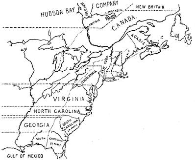
HUSKE’S MAP, 1755.
This is sketched from the colored folding map in John Huske’s Present State of North America, &c., second edition, London, 1755. The easterly of the two pricked (dots) lines marks the limits within which the French claimed to confine the English seaboard colonies. Canada, or the region north of the St. Lawrence, east of the Ottawa, and south of the Hudson Bay Company and New Britain, together with the islands in the Gulf of St. Lawrence, and the northerly coasts of Newfoundland (to dry fish upon), constitute all that the British allowed to France. The stars represent the forts which they had established in the disputed territory; while the circle and dot show the frontier fortified posts of the English, as Huske gives them. The English claimed for the province of New York all the territory north of the Virginia line, west of Pennsylvania, and west of the Ottawa, and south of the Hudson Bay Company’s line. Virginia, the two Carolinas, and Georgia extended indefinitely westward. The northern line of Virginia was established by the charter of 1606; the southern bounds mark where the Carolina charter of 1665 begins, and the bounds of Spanish Florida denote that charter’s southern limit, the territory being divided by the subsequent grant of Georgia. The space between the pricked line, already mentioned, and the other pricked line, which follows the Mississippi River to the north, is the land which is called in a legend on the map the hereditary and conquered country of the Iroquois, which had been ceded by them to the British crown by treaties and a deed of sale (1701), and confirmed by the treaties of Utrecht and Aix-la-Chapelle. Cf. Description of the English and French territories in North America, being an explanation of a new map, shewing the encroachments of the French, with their Forts and Usurpations on the English settlements; and the fortifications of the latter. Dublin, 1755 (Carter-Brown, iii. 1056).
Jefferys pirated Evans’ map, and published it in 1758, “with improvements by I. Gibson,” and in this form it is included in Jefferys’ General Topography of North America and the West Indies, London, 1768. Pownall, who was accused of procuring the dedication of the original[85] issue by “a valuable consideration” (Mass. Hist. Coll., vii. 136), called Jefferys’ reproduction badly done, and reissued Evans’ work in 1776, under the following title: A map of the Middle British Colonies in North America, first published by Mr. Lewis Evans of Philadelphia in 1755, and since corrected and improved, as also extended ... from actual surveys now lying at the Board of Trade, by T. Pownall, M. P., Printed and published for J. Almon, London, March 25, 1776. In this form the original plate was used as “Engraved by James Turner in Philadelphia,” embodying some corrections, while the extensions consisted of an additional engraved sheet, carrying the New England coasts from Buzzard’s to Passamaquoddy Bay.
A French copy, with amendments, was published in 1777.[153]
The map was also reëngraved in London, “carefully copied from the original published at Philadelphia by Mr. Lewis Evans.” It omits the dedication to Pownall, and is inscribed “Printed for Carrington Bowles, London; published, Jan. 1, 1771.” It has various legends not on Evans’ map, and omits some details, notwithstanding its professed correspondence. Evans had used the Greek character [Greek: ch] to express the gh of the Indian names, which is rendered in the Bowles map ch.
Another plate of Evans’ map was engraved in London, and published there by Sayer and Bennett, Oct. 15, 1776, to show the “seat of war.” It covers the same field as the map of 1755, and uses the same main title; but it is claimed to have been “improved from several surveys made after the late war, and corrected from Governor Pownall’s late map, 1776.” The side map is extended so as to include Lake Superior, and is called “A sketch of the upper parts of Canada.” Smith (1756) says: “Evans’ map and first pamphlet were published in the summer, 1755, and that part in favor of the French claim to Frontenac was attacked by two papers in the N. Y. Mercury, Jan. 5, 1756. This occasioned the publication of a second pamphlet the next spring, in which he endeavors to support his map.” [154]
Evans’ pamphlet is called Geographical, historical, political, philosophical, and mechanical essays. The first, containing an analysis of a general map of the middle British colonies in America; and of the country of the confederate Indians [etc.]. Philadelphia, 1755. iv. 32 pp. 4º. A second edition, with the title unchanged, appeared the same year, while “Part ii.” was published in the following year.[155]
By Gen. Shirley’s order N. Alexander made a map of the frontier posts from New York to Virginia, which is noted in the Catal. of the King’s maps (British Museum), ii. 24. This may be a duplicate of a MS. map said by Parkman (i. p. 422) to be in the Public Record office, America and West Indies, lxxxii., showing the position of thirty-five posts from the James River to Esopus on the Hudson.
Le Page du Pratz gave a “Carte de la Louisiane, par l’Auteur, 1757,” in his Histoire de la Louisiane (vol. i. p. 138), a part of which map is reproduced herewith. See also ante, p. 66.
In the Gentleman’s Magazine, 1757, p. 74, is “A map of that part of America which was the principal seat of war in 1756,” defining the Ottawa River as the bounds under the treaty of Utrecht.
Janvier’s L’Amérique, in 1760, carried the bounds of Louisiana to the Pacific.
Pouchot, in a letter dated at Montreal, April 14, 1758, describes a map, which he gives in his Mémoires, vol. iii., where it is called “Carte des frontières Françoises et Angloises dans le Canada depuis Montreal jusques au Fort Du Quesne.” It is reproduced in Dr. Hough’s translation of Pouchot, in the Pennsylvania Archives, second series, vi. p. 409, and in N. Y. Col. Hist., vol. x.
In 1760 Thomas Jefferys included a map of Canada and the north part of Louisiana in The Natural and Civil History of the French Dominion in North and South America, purporting to be “from the French of Mr. D’Anville, improved with the back settlements of Virginia and course of the Ohio, illustrated with geographical and historical remarks,” with marginal tables of “French Incroachments,” and “English titles to their settlements on the Continent.” This map ran the northern bounds of the English possessions along the St. Lawrence, up the Ottawa, across the lakes, and down the Illinois and the Mississippi. The northern bounds of Canada follow the height of land defining the southern limits of the Hudson Bay Company.
After the peace of 1763, Jefferys inserted copies of this map (dated 1762) in the Topography of North America and the West Indies (London, 1768), adding to it, “the boundaries of the Provinces since the Conquest laid down as settled by the King in Council.” The map of[86] 1762 is reproduced in Mills’ Boundaries of Ontario.[156]
Jefferys also gave in the same book (1768) a map of the mouths of the Mississippi and the neighboring coasts, which, he says, was taken from several Spanish and French drafts, compared with D’Anville’s of 1752 and with P. Laval’s Voyage à� Louisiane.

LOUISIANA. (Le Page du Pratz.)
FOOTNOTES:
[1] [See Vol. IV. p. 351. — Ed.]
[2] [There were two stations established to draw off by missionary efforts individual Iroquois from within the influences of the English. One of them was at Caughnawaga, near Montreal, and the other was later established by Picquet at La Présentation, about half-way thence to Lake Ontario, on the southern bank of the St. Lawrence river. Cf. Parkman, Montcalm and Wolfe, i. 65. — Ed.]
[3] [“Hundreds of white men have been barbarized on this continent for each single red man that has been civilized.” Ellis, Red Man and White Man in North America, p. 364.— Ed.]
[4] [See Vol. IV. p. 195. — Ed.]
[5] [See post, chap. ii. — Ed.]
[6] [See chapters vii. and viii. — Ed.]
[7] [See post, chap. viii. — Ed.]
[8] [The treaty of Utrecht, made in 1713, had declared the Five Nations to be “subject to the dominion of Great Britain,” and under this clause Niagara was held to be within the Province of New York; and Clinton protested against the French occupation of that vantage-ground.— Ed.]
[9] While waiting until the Court should name a successor to M. de Vaudreuil, M. de Longueuil, then governor of Montreal, assumed the reins of government.
[10] [See Vol. IV. p. 307. — Ed.]
[11] [See the map in Vol. IV. p. 200. — Ed.]
[12] [See Vol. II. p. 468. — Ed.]
[13] [Parkman (Montcalm and Wolfe, vol. i. chap. ii.) tells the story of this expedition under Céloron de Bienville, sent by La Galissonière in 1749 into the Ohio Valley to propitiate the Indians and expel the English traders, and of its ill success. He refers, as chief sources, to the Journal of Céloron, preserved in the Archives de la Marine, and to the Journal of Bonnecamp, his chaplain, found in the Dépôt de la Marine at Paris, and to the contemporary documents printed in the Colonial Documents of New York, in the Colonial Records, and in the Archives (second series, vol. vi.) of Pennsylvania.— Ed.]
[14] [There is some confusion in the spelling of this name. A hundred years ago and more, the usual spelling was Allegany. The mountains are now called Alleghany; the city of the same name in Pennsylvania is spelled Allegheny. Cf. note in Dinwiddie Papers, i. 255. — Ed.]
[15] [Mémoire sur les colonies de la France dans l’Amérique septentrionale. — Ed.]
[16] [Céloron’s expedition was followed, in 1750, by the visit of Christopher Gist, who was sent, under the direction of this newly formed Ohio Company, to prepare the way for planting English colonists in the disputed territory. The instructions to Gist are in the appendix of Pownall’s Topographical Description of North America. He fell in with George Croghan, one of the Pennsylvania Scotch-Irish, then exploring the country for the Governor of Pennsylvania; and Croghan was accompanied by Andrew Montour, a half-breed interpreter. The original authorities for their journey are in the New York Colonial Documents, vol. vii., and in the Colonial Records of Pennsylvania, vol. v.; while the Journals of Gist and Croghan may be found respectively in Pownall (ut supra) and in the periodical Olden Time, vol. i. Cf. also Dinwiddie Papers, index. In the Pennsylvania Archives, second series, vol. vi., are various French and English documents touching the French occupation of this region.—Ed.]
[17] Prior to this time there had been such an occupation of some of these posts as to find recognition in the maps of the day. See map entitled “Amérique septentrionale, etc., par le Sr. D’Anville, 1746,” which gives a post at or near Erie, and one on the “Rivière aux Beuf” (French Creek).
[18] [See, post, the section on the “Maps and Bounds of Acadia,” for the literature of this controversy. — Ed.]
[19] [See post, chap. viii. — Ed.]
[20] Minister of Marine to M. Ducasse (Margry, iv. 294); Same to same (Margry, iv. 297). See also despatches to Iberville July 29 (Margry, iv. 324) and August 5 (Margry, iv. 327).
[21] [See the section on La Salle in Vol. IV. p. 201. — Ed.]
[22] Margry, iv. 3.
[23] In 1697 the Sieur de Louvigny wrote, asking to complete La Salle’s discoveries and invade Mexico from Texas (Lettre de M. de Louvigny, 14 Oct. 1697). In an unpublished memoir of the year 1700, the seizure of the Mexican mines is given as one of the motives of the colonization of Louisiana. Parkman’s La Salle and the Discovery of the Great West, p. 327, note. The memorial of Louvigny is given in Margry, iv. 9; that of Argoud in Margry, iv. 19.
[24] Daniel’s Nos gloires, p. 39; he was baptized at Montreal, July 20, 1661. (Tanguay’s Dictionnaire généalogique.)
[25] [See Vol. IV. pp. 161, 226, 239, 243, 316.— Ed.]
[26] The Minister in a letter alludes to the reports of Argoud from London, August 21, about a delay in starting (Margry, iv. 82).
[27] Charlevoix says the expedition was composed of the “François” and “Renommée,” and sailed October 17. According to Penicaut the vessels were the “Marin” and “Renommée.” The Journal historique states that they sailed from Rochefort September 24. This work is generally accurate. Perhaps there was some authority for that date. The vessels had come down from Rochefort to the anchorage at Rochelle some time before this, and the date may represent the time of sailing from Rochelle. Margry (iv. 213) in a syllabus of the contents of the Journal of Marin, which he evidently regarded as a part of the original document, gives the date of that event as September 5. In the same volume (p. 84) there is a despatch from the Minister to Du Guay, dated October (?) 16, in which he says that “he awaits with impatience the news of Iberville’s sailing, and fears that he may be detained at Rochelle by the equinoctial storms.”
[28] The French accounts all say that Pensacola had been occupied by the Spaniards but a few months, and simply to anticipate Iberville. Barcia in his Ensayo cronológico (p. 316) says it was founded in 1696.
[29] Report in Margry, iv. 118, and Journal in Ibid., iv. 157. A third account of the Journal of the “Marin” says there were twenty-two in one biscayenne, twenty-three in the other; fifty-one men in all (Journal in Margry, iv. 242). The six men in excess in the total are probably to be accounted for as the force in the canoes. These discrepancies illustrate the confusion in the accounts.
[30] Despatch of the Minister, July 23, 1698, in Margry, iv. 72; Iberville’s Report, in Margry, iv. 120
[31] [See Hennepin’s maps in Vol IV. pp. 251, 253. — Ed.]
[32] Margry, iv. 190.
[33] The date of this letter is given in the Journal “1686” (Margry, iv. 274). This is probably correct. [See Vol. IV. p. 238.— Ed.].
[34] Ten guns, says the Journal, in Margry, iv. 395. One of twenty-four, one of twelve guns; the latter alone entered the river, says Iberville to the Minister, February 26, 1700, in Margry, vol. iv. p. 361. See also Coxe’s Carolana, preface.
[35] [See post, chap. v. — Ed.]
[36] Journal, in Margry, iv. 397.
[37] Instructions, in Margry, iv. 350.
[38] Minister to Iberville, June 15, 1699, in Margry, iv. 305; Same to same, July 29, 1699, in Ibid., iv. 324; Same to same, Aug. 5, 1699, in Ibid., iv. 327.
[39] [See Vol. IV. p. 239. — Ed.]
[40] Journal historique, etc., pp. 30, 34.
[41] The language used in the text is fully justified by the accounts referred to. Students of Indian habits dispute the despotism of the Suns, and allege that the hereditary aristocracy does not differ materially from what may be found in other tribes. See Lucien Carr’s paper on “The Mounds of the Mississippi Valley historically considered,” extracted from Memoirs of the Kentucky Geological Survey, ii. 36, note. See also his “The Social and Political Position of Woman among the Huron Iroquois Tribes,” in the Report of Peabody Museum, iii. 207, et seq.
[42] Pontchartrain to Callières and Champigny, June 4, 1701, in Margry, v. 351. Charlevoix speaks of Saint-Denys, who made the trip to Mexico, as Juchereau de Saint-Denys. Dr. Shea, in the note, p. 12, vol. vi. of his Charlevoix, identifies Saint-Denys as Louis Juchereau de Saint-Denys. The founder of the settlement on the “Ouabache” signed the same name to the Memorial in Margry, v. 350. The author of Nos gloires nationales asserts (vol. i. p. 207 of his work) that it was Barbe Juchereau who was sent to Mexico. Spanish accounts speak of the one in Mexico as Louis. Charlevoix says he was the uncle of Iberville’s wife. Iberville married Marie-Thérèse Pollet, granddaughter of Nicolas Juchereau, Seigneur of Beauport and St. Denis (see Tanguay). This Nicolas Juchereau had a son Louis, who was born Sept. 18, 1676. Martin says the two Juchereaus were relatives.
[43] The establishment was apparently made on the Ouabache (Ohio), Journal historique, etc., pp. 75-89. Iberville, writing at Rochelle, Feb. 15, 1703, says “he will go to the ‘Ouabache,’” in letter of Iberville to Minister (Margry, iv. 631). Penicaut speaks of it as on the Ouabache (Margry, v. 426-438).
[44] Journal historique, etc., p. 106. Charlevoix (vol. ii. liv. xxi. p. 415) says: “It could not be said that there was a colony in Louisiana — or at any rate it did not begin to shape itself — until after the arrival of M. Diron d’Artaguette with an appointment as commissaire-ordonnateur.”
[45] Journal historique, etc., p. 129, and Le Page du Pratz, i. 15, 16. Saint-Denys was evidently duped by the Spaniards. Crozat was anxious for trade. Saint-Denys arranged matters with the authorities at Mexico, and joined in the expedition which established Spanish missions in the “province of Lastekas.” In these missions he saw only hopes of trade; but the title to the province was saved to Spain by them, and no trade was ever permitted.
[46] The following itinerary of this expedition is copied, through the favor of Mr. Theodore F. Dwight, from a rough memorandum in the handwriting of Thomas Jefferson, — which memorandum is now in the Department of State at Washington.
“Oct. 25. Graveline and the other arrived at Rio Bravos at Ayeches, composed of 10 cabbins, they found a Span. Mission of 2 Peres Recollets, 3 souldiers and a woman; at Nacodoches they found 4 Recollets, with a Frere, 2 souldiers and a Span. woman; at Assinays or Cenis 2 Peres Recollets, 1 souldier, 1 Span. woman. The presidio which had been 17 leagues further off now came and established itself at 7 leagues from the Assinayes; it was composed of a Captn, ensign and 25 souldiers. They reached the presidio 2 leagues W. of the Rio Bravo where there was a Capt. Lieut. and 30 souldiers Span. and 2 missions of St. Jean Baptiste and St. Bernard. All the goods of St. Denys were seized and in the end lost. On the return of Graveline and the others they found a Span. Mission at Adayes, founded Jan. 29, 1717.”
[47] The livre is substantially the same as the franc, and by some writers the words are used interchangeably.
[48] There were outstanding, when the bank collapsed, notes of the nominal value of 1,169,072,540 livres. Statements of the amounts in hand, of those which had been burned, etc., showed that there had been emitted more than 3,000,000,000 livres (Forbonnais, ii. 633).
[49] This is exclusive of an issue of 24,000 shares by the Regent. The par value of the 600,000 shares was 300,000,000 livres; but the value represented by them on the basis of the premiums at which they were respectively issued, amounted to 1,677,500,000 livres.
[50] Forbonnais, Recherches et considérations sur les finances de France, ii. 604, says shares rose as high as eighteen to twenty thousand francs.
[51] The commanders of the post in the early days of the colony have been generally spoken of as governors. Gayarré (i. 162) says, “The government of Louisiana was for the second time definitely awarded to Bienville.” He was, as we have seen, lieutenant du roy. As such he was at the head of the colony for many years, and he still held this title when he was by letter ordered to assume command after La Mothe left and until L’Epinay should arrive (Margry, v. 591). In 1716 he was “commandant of the Mississippi River and its tributaries” (Journal historique, etc., pp. 123, 141). His power as commandant-général was apparently for a time shared with his brother Sérigny. In a despatch dated Oct. 20, 1719, quoted by Gayarré, he says, “Mon frère Sérigny, chargé comme moi du commandement de cette colonie.” M. de Vallette Laudun, in the Journal d’un voyage (Paris, 1768), on the 1st of July, 1720, says, M. de Bienville “commands in chief all the country since the departure of his brother, Monsieur de Sérigny.” In 1722 Bienville applied for the “general government” (Margry, v. 634).
[52] Margry, v. 589; Shea’s Charlevoix, vi. 37.
[53] Vergennes, p. 161. “The inhabitants trembled at the sight of this licentious soldiery.”
[54] The Penicaut narrative apparently assigns the year 1717 as the date of the original foundation of New Orleans. Margry (v. 549) calls attention in a note to the fact that the Journal historique, which he attributes to Beaurain, gives 1718 as the date. Gravier, in his Introduction to the Relation du voyage des dames religieuses Ursulines, says that New Orleans was founded in 1717. He cites in a note certain letters of Bienville which are in the Archives at Paris; but as he does not quote from them, we cannot tell to what point of the narrative they are cited as authority.
[55] [From Le Page du Pratz, Histoire de la Louisiane, ii. 262. — Ed.]
[56] [Cf. Vol. II. index. — Ed.]
[57] [There is a “Plan de la Baye de Pansacola,” by N. B., in Charlevoix, iii. 480. Jefferys’s “Plan of the Harbor and Settlement of Pensacola,” and the view of Pensacola as drawn by Dom Serres, are contained in Roberts’s Account of the First Discovery and Natural History of Florida (London, 1763), and in the General Topography of North America and the West Indies (London, 1768), no. 67. The map shows Pensacola as destroyed in 1719, and the new town on Santa Rosa Island. — Ed.]
[58] For the points involved in the discussion of the Louisiana boundary question, see Waite’s American State Papers (Boston, 1819), vol. xii.
[59] Vergennes, p. 153; Champigny, p. 16.
[60] Thomassy, p. 31.
[61] Champigny, p. 127, note 5. “They were obliged to change boats from smaller to smaller three times, in order to bring merchandise to Biloxi, where they ran carts a hundred feet into the ocean and loaded them, because the smallest boats could not land.”
[62] “Clérac” is thus translated by authority of Margry, v. 573, note. He says it means a workman engaged in the manufacture of tobacco, and is derived from the territory of Clérac (Charcute-Inférieure). With this interpretation we can understand why one of the grants was “Celle des Cléracs aux Natchez” (Dumont, ii. 45).
[63] [See Vol. IV. p. 161. — Ed.]
[64] Natchez is never mentioned by the French writers except with expressions of admiration for its soil, climate, and situation. Dumont (vol. ii. p. 63) says “the land at Natchez is the best in the province. This establishment had begun to prosper.” The number of killed at the massacre is stated at “more than two hundred” by Father Le Petit (Lettres édifiantes, xx. 151). Writers like Dumont and Le Page du Pratz state the number at more than seven hundred. Even the smaller number is probably an exaggeration. The value of the tobacco produced at Natchez is alluded to in Champigny; but the place does not seem to have rallied from this blow. Bossu, in 1751, speaks of the fertility of its soil, “if it were cultivated.”
[65] The Capuchin in charge of the post at Natchez was away. The Jesuit Du Poisson, from the Akensas, happened to be there, and was killed.
[66] Clairborne in his Mississippi as a Province, Territory, and State, places the fort of the Natchez in Arkansas, at a place known as “Sicily Island,” forty miles northwest from Natchez.
[67] “I am the only one of the French who has escaped sickness since we have been in this country.” Du Poussin from the Akensas, in Kip, p. 263.
[68] Poussin (De la puissance Américaine, Paris, 1843, i. 262) says: “Nevertheless, about this time (1751) the inhabitants began to understand the necessity of seriously occupying themselves with agricultural pursuits.”
[69] The Present State of the Country and Inhabitants, European and Indians, of Louisiana (London, 1744).
[70] [Cf. Breese, Early History of Illinois, and Vol. IV., p. 198. — Ed.]
[71] “The minute of the surrender of Fort Chartres to M. Sterling, appointed by M. de Gage, governor of New York, commander of His Britannic Majesty’s troops in North America, is preserved in the French Archives at Paris. The fort is carefully described in it as having an arched gateway fifteen feet high; a cut stone platform above the gate, and a stair of nineteen stone steps, with a stone balustrade, leading to it; its walls of stone eighteen feet in height, and its four bastions, each with forty-eight loop-holes, eight embrasures, and a sentry-box; the whole in cut stone. And within was the great storehouse, ninety feet long by thirty wide, two stories high, and gable-roofed; the guard-house, having two rooms above for the chapel and missionary quarters; the government house, eighty-four by thirty-two feet, with iron gates and a stone porch, a coach-house and pigeon-house adjoining, and a large stone well inside; the intendant’s house, of stone and iron, with a portico; the two rows of barracks, each one hundred and twenty-eight feet long; the magazine thirty-five feet wide and thirty-eight feet long, and thirteen feet high above the ground, with a door-way of cut stone, and two doors, one of wood and one of iron; the bake-house, with two ovens and a stone well in front; the prison, with four cells of cut stone, and iron doors; and one large relief gate to the north; the whole enclosing an area of more than four acres.” — Illinois in the Eighteenth Century, by Edward G. Mason, being No. 12 of the Fergus Historical Series, p. 39.
[72] [See map, Vol. IV. p. 200. — Ed.]
[73] Lettres édifiantes et curieuses (Paris, 1758), xxviii. 59. Father Vivier says that five French villages situated in a long prairie, bounded at the east by a chain of mountains and by the River Tamaroa, and west by the Mississippi, comprised together one hundred and forty families. These villages were (Bossu, seconde édition, Paris, 1768, i. 145, note) Kaskaskia, Fort Chartres, St. Philippe, Kaokia, and Prairie du Rocher. There were other posts on the lines of travel, but the bulk of the agricultural population was here. The picture of their life given by Breese is interesting.
Vincennes is said by some authorities to have been founded as early as 1702. See Bancroft (New York, 1883), ii. 186; also A Geographical Description of the United States by John Melish. C. F. Volney, the author of Tableau du climat et du sol des états-Unis d’Amérique (Paris, 1803), was himself at Poste Vincennes in 1796. He says (p. 401): “I wished to know the date of the foundation and early history of Poste Vincennes; but spite of the authority and credit that some attribute to tradition, I could scarcely get any exact notes about the war of 1757, notwithstanding there were old men who dated back prior to that time. It is only by estimate that I place its origin about 1735.” In Annals of the West, compiled by James R. Albach, the authorities for the various dates are given. The post figures in some of the maps about the middle of the century.
[74] “We receive from the Illinois,” he says, “flour, corn, bacon, hams both of bear and hog, corned pork and wild beef, myrtle and bees-wax, cotton, tallow, leather, tobacco, lead, copper, buffalo-wool, venison, poultry, bear’s grease, oil, skins, fowls, and hides” (Martin’s History of Louisiana, i. 316).
[75] Pownall in his Administration of the Colonies (2d ed., London, 1765, appendix, section 1, p. 24) gives a sketch of the condition of the colonies, derived mainly from Vaudreuil’s correspondence. He says that Vaudreuil (May 15, 1751) thought that Kaskaskia was the principal post, but that Macarty, who was on the spot (Jan. 20, 1752), thought the environs of Chartres a far better situation to place this post in, provided there were more inhabitants. “He visited Fort Chartres, found it very good,— only wanting a few repairs, — and thinks it ought to be kept up.”
[76] Fort Chartres is stated by Mr. Edward G. Mason, in Illinois in the Eighteenth Century (Fergus Historical Series, no. 12, p. 25), to be sixteen miles above Kaskaskia. In the Journal historique, etc. (Paris and New Orleans, 1831), p. 221, the original establishment of Boisbriant is stated to have been “eight leagues below Kaskaskia,” and (p. 243) it is stated that it was transferred “nine leagues below” the village. French, in his Louisiana Historical Collections, published a translation of a manuscript copy of the Journal historique which is deposited in Philadelphia. His translation reads that the transfer was made to a point “nine leagues above Kaskaskia.” Martin, who worked from still another copy of the Journal historique, states that the establishment was transferred to a point twenty-five miles above Kaskaskia. The “au dessous” (p. 243 of Journal historique, or, as ordinarily cited, “La Harpe” ) was probably a typographical error.
[77] This ground was partly prospected by Dutisné, who, Nov. 22, 1719, wrote to Bienville an account of an expedition to the Missouris by river and to the Osages and Paniouassas by land. Bournion, whose appointment was made, according to Dumont, in 1720, went up the river to the Canzes, and thence to the Padoucahs in 1724. Le Page du Pratz gives an account of the expedition. The name of this officer is variously given as Bournion in the Journal historique, Bourgmont by Le Page du Pratz, Bourmont by Bossu, and Boismont by Martin.
[78] Neyon de Villiers.
[79] [See post, chap. viii. — Ed.]
[80] [“The English colonies ... at the middle of the century numbered in all, from Georgia to Maine, about 1,160,000 white inhabitants. By the census of 1754 Canada had but 55,000. Add those of Louisiana and Acadia, and the whole white population under the French flag might be something more than 80,000.” Parkman, Montcalm and Wolfe, i. 20. — Ed.]
[81] [See post, chap. vii. — Ed.]
[82] [“In the dual government of Canada the governor represented the king, and commanded the troops; while the intendant was charged with trade, finance, justice, and all other departments of civil administration. In former times the two functionaries usually quarrelled; but between Vaudreuil and Bigot there was perfect harmony” (Parkman, Montcalm and Wolfe, ii. 18). Foremost among the creatures of Bigot, serving his purposes of plunder, were Joseph Cadet, a butcher’s son whom Bigot had made commissary-general, and Marin, the Intendant’s deputy at Montreal, who repaid his principal by aspiring for his place. It was not till February, 1759, when Montcalm was given a hand in civil affairs, that the beginning of the end of this abandoned coterie appeared (see Ibid., ii. 37, for sources). Upon the interior history of Canada, from 1749 to 1760, there is a remarkable source in the Mémoires sur le Canada, which was printed and reprinted (1873) by the Literary and Historical Society of Quebec. It reached the committee from a kinsman of General Burton, of the army of General Amherst, who presumably received it from its anonymous author, and took it to England for printing. Smith, in his History of Canada (1815), had used a manuscript closely resembling it. Parkman refers to a manuscript in the hands of the Abbé Verreau of Montreal, the original of which he thinks may have been the first draught of these Mémoires. This manuscript was in the Bastille at the time of its destruction, and being thrown into the street, fell into the hands of a Russian and was carried to St. Petersburg. Lord Dufferin, while ambassador to Russia, procured the Verreau copy, which differs, says Parkman, little in substance from the printed Mémoires, though changed in language and arrangement in some parts (Parkman, Montcalm and Wolfe, ii. 37). The second volume of the first series of the Mémoires of the Literary and Historical Society of Quebec also contains a paper, evidently written in 1736, and seemingly a report of the Intendant Hocquart to Cardinal Fleury, the minister of Louis XV. In the same collection is a report, Considérations sur l’état présent du Canada, dated October, 1758, which could hardly have been written by the Intendant Bigot, but is thought to have been the writing of a Querdisien-Trémais, who had been sent as commissioner to investigate the finances, and who deals out equal rebuke upon all the functionaries then in office.— Ed.]
[83] [Histoire et description générale de la Nouvelle France, avec le journal historique d’un voyage fait par ordre du roi dans l’Amérique septentrionale (Paris, 1744). It is in three volumes, the third containing the Journal (cf. Vol. IV. p. 358), of which there are two distinct English translations, — one, Journal of a Voyage to North America, in two volumes (London, 1761; reprinted in Dublin, 1766); the other, Letters to the Duchess of Lesdiguierres (London, 1763), in one volume. A portion of the Journal is also given in French’s Historical Collections of Louisiana part iii. (Cf. Sabin, no. 12,140, etc.; Carter-Brown, vol. iii. nos. 1,285, 1,347, 1,497.) The Dublin edition of the Journal has plates not in the other editions (Brinley Catalogue, vol. i. no. 80). There is a paper on “Charlevoix at New Orleans in 1721” in the Magazine of American History, August, 1883. — Ed.]
[84] [History and General Description of New France, translated, with Notes, by John Gilmary Shea (New York, 1866), etc., 6 vols. (See Vol. IV. of the present work, p. 358.) Charlevoix’s Relation de la Louisiane is also contained in Bernard’s Recueil de voyages au nord (Amsterdam, 1731-1738). — Ed.]
[85] Upon these expeditions the United States partly based their claims, in the discussions with Spain in 1805 and 1818, on the Louisiana boundary question.
[86] Jean de Beaurain, a geographical engineer, was born in 1696, and died in 1772. He was appointed geographer to the King in 1721. His son was a conspicuous cartographer (Nouvelle biographie générale).
[87] The libraries of the American Philosophical Society (Philadelphia) and of the Department of State (Washington) each have a copy of this manuscript. A copy belonging to the Louisiana Historical Society is deposited in the State Library at New Orleans. [From the Philadelphia copy the English translation in French’s Historical Collections of Louisiana, part iii., was made. A. R. Smith, in his London Catalogue, 1874, no. 1,391, held a manuscript copy, dated 1766, at £7 17s. 6d., and another is priced by Leclerc (Bibl. Amer., no. 2,811) at 500 francs. This manuscript has five plans and a map, while the printed edition of 1831 has but a single map. The manuscripts are usually marked as “Dédié et présenté au roi par le Chevalier Beaurain,” who is considered by Leclerc as the author of the drawings only. — Ed.]
[88] Ferland, ii. 343; Garneau, ii. 94. For characterizations of these and other authorities on Canada, see Vol. IV. of this History, pp. 157, 360.
[89] [It consists of two series of lectures, the first entitled The Poetry, or the Romance of the History of Louisiana, and the second, Louisiana, its History as a French Colony. He says in a preface to a third series, printed separately in 1852 at New York, — Louisiana, its History as a French Colony, Third Series of Lectures (Sabin, vol. vii. nos. 26,793, 26,796), — that the first series was given to “freaks of the imagination,” the second was “more serious and useful” in getting upon a basis more historic; while there was a still further “change of tone and manner” in the third, which brings the story down to 1769. This was published at New York in 1851. Mr. Gayarré had already published, in 1830, an Essai historique sur Louisiane in two volumes (Sabin vol. vii. nos. 26,791, 26,795), and Romance of the History of Louisiana, a Series of Lectures, New York, 1848 (Sabin, vol. vii. nos. 26,795, 26,797, 26,799). — Ed.]
[90] This was published at New Orleans in 1846-1847 in two volumes (Sabin, vol. vii. no. 26,792).
[91] Published as History of Louisiana: the Spanish Domination, the French Domination, and the American Domination, — the three parts respectively in 1854, 1855, and 1866.
[92] [There are many papers on Louisiana history in De Bow’s Review, and for these, including several reviews of Gayarré, see Poole’s Index to Periodical Literature, p. 772, where other references will be found to the Southern Literary Messenger, etc. — Ed.]
[93] [The original edition was published at Paris in 1758. An English version, The History of Louisiana, or the Western Parts of Virginia and Carolina; containing a Description of the Countries that lie on both sides of the River Mississippi, appeared in London in 1763 (two vols.) and 1774 (one vol.), in an abridged and distorted form (Carter-Brown, vol. iii. no. 1,352; Sabin, x. 223; Field, Indian Bibliography, nos. 910-912). H. H. Bancroft (Northwest Coast, i. 598) mentions a different translation published in 1764; but I have not seen it. Field says of the original: “It is difficult to procure the work complete in all the plates and maps, which should number forty-two.” — Ed.]
[94] The authorities upon which are based the statements of most writers upon the history of Louisiana have been exhumed from the archives in Paris, but there are French sources for narratives of the adventures of Saint-Denys which are still missing. Le Page du Pratz (i. 178) says: “What I shall leave out will be found some day, when memoirs like these of M. de Saint-Denis and some others concerning the discovery of Louisiana, which I have used, shall be published.”
[95] [It was issued in two volumes at Paris in 1753 (Carter-Brown, vol. iii. no. 996; Leclerc, no. 2,750, thirty francs; Field, Indian Bibliography, no. 463). — Ed.]
[96] Journal historique, etc., p. 310.
[97] Nouvelle biographie générale, sub “Butel Dumont.”
[98] Considérations géographiques, etc., par Philippe Buache (Paris, 1753), p. 36. See Vol. II. p. 461.
[99] He tells of a rattlesnake twenty-two feet long, in vol. i. p. 109; and of frogs weighing thirty-two pounds, in vol. ii. p. 268.
[100] [It was published at Paris in 1768, and an English translation, Travels through that part of North America formerly called Louisiana (by J. R. Forster), was printed in London, in 2 vols., in 1771, and a Dutch version at Amsterdam in 1769. The original French was reprinted at Amsterdam in 1769 and 1777. — Ed.]
[101] Vergennes, p. 157. “In considering the savages who were drawn into an alliance with us by our presents, and who received us into their houses, would it have been difficult to attach them to us if we had acted toward them with the candor and rectitude to which they were entitled? We gave them the example of perfidy, and we are doubly culpable for the crimes they committed and the virtues they did not acquire.”
[102] [See Vol. IV. pp. 199, 316. The book forms no. 8 of Munsell’s Historical Series. See accounts of Le Sueur and other explorers of the Upper Mississippi in Neill’s Explorers and Pioneers of Minnesota. There are extracts from Le Sueur’s Journal in La Harpe’s Journal historique and in French’s Historical Collections of Louisiana, part iii.; and in the new series (p. 35 of vol. vi.) of the same Collections is a translation of Penicaut’s Annals of Louisiana from 1698 to 1722. The translation was made from a manuscript in the National Library at Paris. Kaskaskia in Illinois is looked upon as the earliest European settlement in the Mississippi Valley; it was founded by Jacques Gravier in 1700. Cf. Magazine of American History, March, 1881. There had been an Indian town on the spot previously, and Father Marquette made it his farthest point in 1675. — Ed.]
[103] [On these books see Vol. IV. pp. 294, 316, where Dr. Shea gives reasons for supposing the earliest publication of the Lettres to have been in 1702. Cf. Sabin’s American Bibliopolist (1871), p. 3; H. H. Bancroft’s Mexico, ii. 191; and the Nouvelles des missions, extraites des lettres édifiantes et curieuses: Missions de l’Amérique, 1702-1743 (Paris, 1827). — Ed.]
[104] [It was first printed in London in 1775, and afterward appeared in 1782 at Breslau, in a German translation. Cf. Field, Indian Bibliography, no. 11. The Mémoire de M. de Richebourg sur la première guerre des Natchez is given in French’s Collections, vol. iii. A paper on the massacre of St. André is in the Magazine of American History (April, 1884), p. 355. Dr. Shea printed in 1859, from a manuscript in the possession of Mr. J. Carson Brevoort (as no. 9 of his series, one hundred copies), a Journal de la guerre du Micissippi contre les Chicachas, en 1739 et finie en 1740, le 1er d’avril. Par un officier de l’armée de M. de Nouaille. Cf. Field, Indian Bibliography, no. 807. — Ed.]
[105] [The original was published at Paris in 1829; in 1830 it was printed in English at Philadelphia as The History of Louisiana, particularly of the Cession of that Colony to the United States of America. It is said to be translated by the publicist, William Beach Lawrence.— Ed.]
[106] [It was reprinted in 1726, again in 1727, and with a lengthened title in 1741 (Carter-Brown, vol. iii. nos. 315, 372, 376, 679; Sabin, vol. v. nos. 17, 276, etc.). The edition of 1741 made part of A Collection of Voyages and Travels, edited by Coxe, which contained: “1. The dangerous voyage of Capt. Thomas James in his intended discovery of a northwest passage into the South sea (in 1631-1632). 2. An authentick and particular account of the taking of Carthagena by the French in 1697 by Sieur Pointis. 3. A description of the English province of Carolana; by the Spaniards call’d Florida, and by the French La Louisiane. By Daniel Coxe.” Coxe’s narrative of explorations is also included in French’s Historical Collections of Louisiana, vol. ii. Coxe’s map, which is repeated in the various editions, is called: “Map of Carolana and the River Meschacebe.” A section of it is given on the next page. — Ed.]
[107] Coxe’s Carolana, p. 118. The writer of an article in the North American Review, January, 1839, entitled “Early French Travellers,” says: “An examination of contemporary writers and the town records has failed to lend a single fact in support of the Doctor’s tale.” Cf. H. H. Bancroft, Northwest Coast, i. 122, 123. [The French as traders and missionaries easily gained a familiarity with the Valley of the Mississippi, before agricultural settlers like the English had passed the Alleghanies. There had, however, been some individual enterprises on the part of the English. Coxe claims that under the grant to Sir Robert Heath, in 1630, of the region across the continent between 31� and 36�, Colonel Wood and a Mr. Needham explored the Mississippi Valley between 1654 and 1664, and that during the later years of that century other explorers had thridded the country.— Ed.].
[108] [See Vol. II. p. 462. — Ed.]
[109] His account of Fort Chartres is quoted in the appendix of Mills’s Boundaries of Ontario, p. 198. His plan of Mobile Bay (p. 55), may be compared with one in Roberts’s Account of the First Discovery and Natural History of Florida (London, 1763), p. 95.
[110] [The Early History of Illinois, from its Discovery by the French, in 1673, until its Cession to Great Britain in 1763, including the Narrative of Marquette’s Discovery of the Mississippi. With a Biographical Memoir by Melville W. Fuller. Edited by Thomas Hoyne (Chicago, 1884). It has three folded maps. — Ed.]
[111] [Cf., for these and other titles, Vol. IV. pp. 198, 199. The routes of Marquette by Green Bay, and of La Salle by the St. Joseph River, had been the established method of communication of the French in Canada with Louisiana in the seventeenth century; but as they felt securer in the Ohio Valley, in 1716, they opened a route by the Miami and Wabash, and later from Presqu’ Isle on Lake Erie to French Creek, thence by the Alleghany and Ohio. — Ed.]
[112] Bossu, ii. 151.
[113] French (part iii. p. 12, note) says: “The two brothers met in deep mourning, and after mutual embraces the brave D’Iberville sought the tomb of his brother Sauvolle, where he knelt for hours in silent grief.” All this is purely imaginary; and in French’s second series (vol. ii. p. 111, note) he concludes that Sauvolle would appear from the text not to have been Iberville’s brother. This doubt whether Sauvolle was a brother of Iberville penetrates even such a work as Nos gloires nationales. The author not finding such a seigniory, says of François Le Moyne, “We do not know if he followed his brother to Louisiana, and is the same to whom the name Sieur de Sauvole was given,” — all this in face of the record in the previous paragraph of his burial in 1687 (Nos gloires, i. 53). To the account of the massacre at Natchez, in his translation of Dumont, French appends a note (vol. v. p. 76), in which he identifies a ship-carpenter, whose life was spared by the Indians, as “Perricault, who, after his escape, wrote a journal of all that passed in Louisiana from 1700 to 1729.” Penicaut, the spelling of whose name puzzled writers and printers, left the colony in 1721. There was no foundation whatever for the note.
[114] The reader might easily be misled by the title given to the translation of a portion of the second volume of Dumont into the belief that the whole work was before him. There is no mention in French of the preface, or of the appendix to Coxe’s Carolana. Both preface and appendix are full of interesting material.
[115] In this translation French (iii. 83) says: “But notwithstanding these reports, they now create him [Bienville] brigadier-general of the troops, and knight of the military order of St. Louis,” etc. Compare this with the faithful rendering of Martin (i. 229), —“The Regent ... so far from keeping the promise he had made of promoting him to the rank of brigadier-general, and sending him the broad ribbon of the order of St. Louis, would have proceeded against him with severity if he had not been informed that the Company’s agents in the colony had thwarted his views.”
[116] It has all the substantial portions of the copy given in Margry, but there are occasional abridgments and occasional additions. The story of the Margry relation is continuous and uninterrupted; but in the copy given by French items of colonial news are interspersed, and sometimes repeated with variations. It would seem as if the copyist had been unable properly to separate the manuscript from that of some other Relation of colonial affairs, and in the exercise of his discretion had made these mistakes. A comparison of the two accounts will readily disclose their differences. A single example will explain what is meant by repetitions which may have been occasioned by confusion of manuscripts. On p. 145 of vol. vi., or second series vol. i. of French’s Historical Collections of Louisiana occurs the following: On the 17th of March, 1719, “the ship of war ‘Le Comte de Toulouse’ arrived at Dauphin Island.” On p. 146 we find, “On the 19th of April the ships ‘Maréchal de Villars,’ ‘Count de Toulouse,’ and the ‘Phillip,’ under the command of M. de Sérigny, the brother of M. de Bienville, arrived at Dauphin Island.” These two paragraphs, with their contradictory statements about the “Comte de Toulouse,” do not occur in Margry. They are evidently interpolated from some outside source. Thomassy (1860) quotes Annales véritables des 22 premières années de la colonisation de la Louisiane par Pénicaut, as from the “MSS. Boismare, dans la Bibliothèque de l’état à� Bàton-Rouge.”
The camp-fire yarn of Jalot, with its marvellous details about Saint-Denys’ romantic love-affair, the gorgeous establishment of the Mexican viceroy, and the foolhardy trip of Saint-Denys to see his wife, are omitted in French’s translation. They are worthless as history, but they reveal the simplicity of Penicaut, who yielded faith to his fellow-voyagers, in the belief that it was his good fortune to be chosen to tell the story to the world.
[117] [Historical Collections of Louisiana, ... compiled with Historical and Biographical Notes and an Introduction by B. F. French. Part I. Historical Documents from 1678 to 1691 (New York, 1846). This volume contains a discourse before the Historical Society of Louisiana by Henry A. Bullard, its president (originally issued at New Orleans, 1836; cf. Sabin, vol. iii. no. 9,116), and sundry papers relating to La Salle, Tonty, and Hennepin, specially referred to in Vol. IV. of the present History.
Same. Part II. (Philadelphia, 1850). This volume contains a fac-simile of Delisle’s “Carte de la Louisiane et du Cours du Mississipi;” an account of the Louisiana Historical Society, by James Dunwoody Brownson De Bow; a discourse on the character of François-Xavier Martin; an analytical index of the documents in the Paris Archives relating to Louisiana; papers relating to De Soto (which are referred to in Vol. II. chap. iv. of the present History); a reprint of Coxe’s Carolana (omitting, however, the preface and appendix); and Marquette and Joliet’s account of their journey in 1673 (referred to in Vol. IV. of the present History).
Same. Part III. (New York, 1851). This volume includes a memoir of H. A. Bullard; translations of La Harpe, of Bienville’s correspondence, of Charlevoix’s Historical Journal; accounts of the aborigines, including Le Petit’s narratives regarding them; De Sauvolle’s Journal historique, 1699-1701; with other documents relating to the period treated of in the present volume of this History, as well as papers relating to the Huguenots and Ribault (referred to in Vol. II. of this History).
Same. Part IV. (New York, 1852). This volume has a second title-page, — Discovery and Exploration of the Mississippi Valley, with the Original Narratives of Marquette, Allouez, Membré, Hennepin, and Anastase Douay, by John Gilmary Shea, with a fac-simile of the newly discovered map of Marquette (New York, 1852). The contents of this volume are referred to in Vol. IV. of the present History.
Same. Part V. The title in this part is changed to Historical Memoirs of Louisiana, from the First Settlement of the Colony to the Departure of Governor O’Reilly in 1770, with Historical and Biographical Notes (New York, 1853). It includes translations of Dumont’s memoir, another of Champigny, with an appendix of historical documents and elucidations; and all parts of the volume mainly cover the period of the present chapter. It also contains the usual portrait of Bienville, purporting to be engraved from a copy belonging to J. D. B. DeBow, of an original painting in the family of Baron Grant, of Longueil in Canada.
A second series of Mr. French’s publications has the title, Historical Collections of Louisiana and Florida, including Translations of Original Manuscripts relating to their Discovery and Settlement, with Numerous Historical and Biographical Notes. New Series, vol. i. (New York, 1869). This volume contains translations of De Remonville’s memoir (Dec. 10, 1697), of D’Iberville’s narrative of his voyage (1698), of Penicaut’s Annals of Louisiana (1698 to 1722), — all of which pertain to the period of the present volume. It contains also translations of Laudonnière’s Histoire notable de Floride, being that made by Hakluyt (referred to in Vol. II. of the present History).
Same, vol. ii. (New York, 1875). This volume contains, in regard to Louisiana, translations relating to La Salle, Joliet, Frontenac, and New France, which are referred to in Vol. IV. of the present History, as well as the Journal of D’Iberville’s voyage (1698, etc.), and the letter of Jacques Gravier, who descended the Mississippi to meet D’Iberville, — all referred to in the present chapter. In regard to Florida, there are documents of Columbus, Narvaez, Las Casas, Ribault, Grajales, Solis de las Meras, Fontenade, Villafane, Gourgues, etc.,—(all of which are referred to in Vol. II. of the present History).
It is to be regretted that French sometimes abridges the documents which he copies, without indicating such method, — as in the case of Charlevoix and Dumont. — Ed.]
[118] Vol. IV. has the specific title: Découverte par mer des bouches du Mississipi et établissements de Lemoyne d’Iberville sur le golfe du Mexique, 1694-1703, Paris, 1880. Vol. V. is called: Première formation d’une chaà�ne de postes entre le fleuve Saint-Laurent et le golfe du Mexique, 1683-1724, Paris, 1883.
[119] [Particularly in Vol. IV. pp. 213-289, the Journal du voyage fait à� l’embouchure de la rivière du Mississipi (etc.). Cf. the Journal du voyage fait par deux frégattes du roi, La Badine, commandée par M. d’Iberville, et Le Marin, par M. E. Chevalier de Surgères, qui partirent de Brest le 24 octobre, 1698, oà� elles avaient relà�ché, étant parties de Larochelle, le 5 septembre précédent, in Historical Documents, third series, of the Literary and Historical Society of Quebec (48 pp.), published at Quebec in 1871. See also the Catalogue of the Library of Parliament (1858), p. 1613. — Ed.]
[120] [See Vol. IV. p. 242. — Ed.]
[121] [For example, The Present State of the Country ... of Louisiana. By an Officer at New Orleans to his Friend at Paris. To which are added Letters from the Governor [Vaudreuil] on the Trade of the French and English with the Natives, London, 1744 (Carter-Brown, vol. iii. no. 773; Field, Indian Bibliography, no. 955; Sabin, no. 42,283). — Ed.
[122] Gayarré, in his preface, says: “Mr. Magne (one of the editors of the New Orleans Bee) inspected with minute care, and with a discretion which did him honor, the portfolios of the Minister of the Marine in France, and extracted from them all the documents relating to Louisiana, of which he made a judicious choice and an exact copy. Governor Mouton, having learned of this collection, hastened, in his position as a clear-headed magistrate whose duty it was to gather together what might cast light upon the history of the country, to acquire it for account of the State.” It is understood that this Magne Collection was purchased for a thousand dollars at the instance of Mr. Gayarré. It was then deposited in the State Library; but is no longer to be found. A similar disappearance has happened in the case of some other copies which were made for Mr. Edmund Forstall, and were likewise in the State Library; and the same fate has befallen two bound volumes of copies which were made for the Hon. John Perkins while in Europe, and which were by him likewise given to the State Library. Many of these documents were included by Gayarré in his Histoire.
It was also by the influence of Gayarré that the Louisiana Legislature appropriated $2,000 to secure copies of papers from the Spanish Archives. It was committed to the Hon. Romulus Saunders of North Carolina, then the American minister in Madrid, to propitiate the Spanish Government in an application for permission to make copies. He failed, though zealous to accomplish it. Through the medium of Prescott recourse was then had to Don Pascual de Gayangos, who, after difficulties had been overcome, succeeded in getting copies of a mass of papers, which greatly aided Gayarré in his Spanish Domination. These papers, like the rest, found their way to the State Library at Baton Rouge, but disappeared in turn during the Civil War. A small part of them was discovered by Mr. Lyman Draper, of Wisconsin, in the keeping of the widow of a Federal officer, and through Mr. Draper’s instrumentality was restored to the Library. The correspondence of Messrs. Saunders, Gayangos, and Gayarré makes one of the State documents of Louisiana.
A few years since, another movement was made by Mr. Gayarré to get other papers from Spain, impelled to it by information of large diaries (said to be four hundred and fifty-two large bundles) still unexamined in the Spanish Archives, pertaining to Louisiana. The State of Louisiana was not in a condition to incur any outlay; and by motion of General Gibson a Bill was introduced into the National House of Representatives, appropriating $5,000 to procure from England, France, and Spain copies of documents relating to Florida and Louisiana. Nothing seems to have come of the effort beyond the printing of a letter of Mr. Gayarré, with his correspondence with Saunders and Gayangos, which was done by order of a committee to whom the subject was referred. The facts of this note are derived from a statement kindly furnished by Mr. Gayarré.
[There is among the Sparks manuscripts in Harvard College Library a volume marked Papers relating to the Early Settlement of Louisiana, copied from the Originals in the Public Offices of Paris (1697-1753). — Ed.]
[123] Xavier Eyma adopts another form in “La légende du Meschacébé,” — a paper in the Revue Contemporaine (vol. xxxi. pp. 277, 486, 746), in which he traces the history of the explorations from Marquette to the death of Bienville.
[124] Norman McF. Walker on the “Geographical Nomenclature of Louisiana,” in the Mag. of Amer. History, Sept., 1883, p. 211.
[125] See Vol. IV. p. 375.
[126] There is an account of him in the Allg. Geog. Ephemeriden, vol. x. p. 385. See Vol. IV. p. 375.
[127] There are issues of later dates, 1722, etc.
[128] There are portraits and notices of the two in the Allg. Geog. Ephemeriden, published at Weimar, 1802 (vol. x.).
[129] An Atlas Nouveau of forty-eight maps was issued at Amsterdam, with the name of Guillaume Delisle, in 1720, and with later dates. The maps measure 25 à� 21 inches.
[130] There are modern reproductions of it in French’s Hist. Coll. of Louisiana, vol. ii., as dated 1707; in Cassell’s United States, i. 475; and for the upper portion in Winchell’s Geol. Survey of Minnesota, Final Report, vol. i. p. 20. The lower part of it is given in the present work, Vol. II. p. 294.
[131] Géol. practique de la Louisiane, p. 209.
[132] N. Y. Col. Docs., v. 577.
[133] Cf. Bulletin de la Soc. de Géog. d’Anvers, vii. 462. De Fer was born in 1646; died in 1720. His likeness is in Allg. Geog. Ephemeriden, Sept., 1803, p. 265.
[134] This map is worth about $10.00. Moll also published in 1715 a Map of North America, with vignettes by Geo. Vertue, — size 38 à� 23 inches. Moll’s maps at this time were made up into collections of various dates and titles.
[135] This map of North America is reproduced in Lindsey’s Unsettled Boundaries of Ontario, Toronto, 1873. It shows a view of the Indian fort on the “Sasquesahanoch.” Moll’s Minor Atlas, a new and curious set of sixty-two maps, eighteen of which relate to America, was issued in London, without date, ten or fifteen years later. Cf. also “A new map of Louisiana and the river Mississipi,” in Some Considerations on the consequences of the French settling Colonies on the Mississippi, from a gentleman of America to his friend in London. London, 1720.
[136] Thomassy, p. 212.
[137] Senex issued a revision of a map of North America this same year, size 22 X 19 inches. Between 1710 and 1725 Senex’s maps were often gathered into atlases, containing usually about 36 maps.
[138] Thomassy, p. 214.
[139] Sabin, ix. 37,600. Ker was a secret agent of the British government, and Curl, the publisher, was pilloried for issuing the book.
[140] Géologie practique de la Louisiane, p. 2.
[141] Homann, b. 1663; d. at Nuremberg, 1724. There is an account of him in the Allg. Geog. Ephemeriden, Nov., 1801. There are extracts from the despatches of the Governors of Canada, 1716-1726, respecting the controversy over the bounds between the French and English in N. Y. Col. Docs., ix. 960.
[142] Sabin, xv. 64,140.
[143] His Œuvres Géographiques were published collectively at Paris in five volumes in 1744-45. The atlases which pass under his name bear dates usually from 1743 to 1767, the separate maps being distinctively dated, as those of North America in 1746; those of South America in 1748; those of Canada and Louisiana, 1732, 1755, etc.
[144] The upper part of it is reproduced in Andreas’s Chicago, i. 59.
[145] These maps are reproduced in Dr. Shea’s translation of Charlevoix. The map showing the respective possessions of the French, English, and Spanish is reproduced in Bonnechose’s Montcalm et le Canada français, 5th ed., Paris, 1882. By this the English are confined from the Gulf of St. Lawrence to Florida between the Appalachian range and the sea.
[146] Thomassy, p. 219. It is said that the maps first published by Bellin were not thought by the French government sufficiently favorable to their territorial claims, and accordingly he published a new set, better favoring the French. When Shirley, speaking with Bellin, referred to this, Bellin is said to have answered, “We in France must obey the King’s command.”
[147] Page 218.
[148] Cf. his Remarques sur la Carte de l’Amérique, Paris, 1755.
[149] Sabin, xv. 34,027; and xv. p. 448.
[150] Referring to the maps (1756), Smith, the New York historian (Hist. N. York, Albany, 1814, p. 218), says: “Dr. Mitchell’s is the only authentic one extant. None of the rest concerning America have passed under the examination or received the sanction of any public board, and they generally copy the French.” Cf. C. C. Baldwin’s Early Maps of Ohio, p. 15.
[151] It is also contained in the Atlas Amériquain, 1778, no. 335, where it is described as “traduit de l’Anglais par le Rouge,” and is dated 1777, “Corigée en 1776 par M. Hawkins.” A section of this map is also included in the blue book, North American Boundary, Part I., 1840.
Parkman (Montcalm and Wolfe, i. 126) says: “Mitchell pushed the English claim to its utmost extreme, and denied that the French were rightful owners of anything in North America, except the town of Quebec and the trading post of Tadoussac.” This claim was made in his Contest in America between Great Britain and France, with its consequences and importance, London, 1757.
[152] Thomson’s Bibliog. of Ohio, no. 384; Sabin, vi. p. 272; Baldwin’s Early Maps of Ohio, 15; Haven in Thomas’ Printing, ii. p. 525. The main words of the title are: A General Map of the Middle British Colonies in America ... of Aquanishuonîgy, the country of the Confederate indians, Comprehending Aquanishuonîgy proper, their place of residence; Ohio and Tiiughsoxrúntie, their deer-hunting countries; Coughsaghrà�ge and Skaniadarà�de, their beaver-hunting Countries ... wherein is also shewn the antient and present seats of the Indian Nations. By Lewis Evans, 1755.
The map extends from the falls of the Ohio to Narragansett Bay, and includes Virginia in the south, with Montreal and the southern end of Lake Huron in the north. It is dedicated to Pownall, and has a side map of “The remaining part of Ohio R., etc.,” which shows the Illinois country. In the lower right-hand corner it is announced as “Published by Lewis Evans, June 23, 1755, and sold by Dodsley, in London, and the author in Philadelphia.” The map measures 20-1/2 X 27-1/2 inches.
[153] Harv. Coll. Atlases, no. 354, pp. 3-6.
[154] Hist. New York (1814), p. 222. Evans says: “The French being in possession of Fort Frontenac at the peace of Ryswick, which they attained during their war with the Confederates, gives them an undoubted title to the acquisition of the northwest side of St. Lawrence river, from thence to their settlement at Montreal.” (p. 14.)
[155] Harv. Col. lib’y, 6371.8; Boston Pub. lib’y [K. 11.7], and Carter-Brown, iii. 1059, 1113.
[156] The occasion of Mills’ Report on the boundaries of Ontario (1873) was an order requiring him to act as a special commissioner to inquire into the location of the western and northern bounds of Ontario, — the Imperial Parliament having set up (1871), as it was claimed, the new Province of Manitoba within the legal limits of Ontario, which held by transmission the claims westward of the Province of Quebec and later those of Upper Canada.
Notes
- Capuchin A Catholic friar.
Text prepared by:
Winter 2020-2021
- Aaron Calhoun
- Stacy Cook
- Nichole Davis
Source
Cable, George Washington. "Posson Jone'" and Père Raphaà�l: With a New Word Setting Forth How and Why the Two Tales Are One. Illus. Stanley M. Arthurs. New York: Charles Scribner's Sons, 1909. Google Books. Web. 27 Feb. 2012. <http://books. google.com/books?id=bzhLAAAAIAAJ>.